319 Visitors Tracking The Tropics!

Website: TrackTheTropics.com/DONATE
Venmo: @TrackTheTropicsLouisiana
Cash App: Cash.App/$TrackTheTropics
Subscribe: FB.com/TrackTheTropics

Track The Tropics is the #1 source to track the tropics 24/7! Since 2013 the main goal of the site is to bring all of the important links and graphics to ONE PLACE so you can keep up to date on any threats to land during the Atlantic Hurricane Season! Hurricane Season 2026 in the Atlantic starts on June 1st and ends on November 30th. Do you love Spaghetti Models? Well you've come to the right place!! Remember when you're preparing for a storm: Run from the water; hide from the wind!
Tropical Atlantic Weather Resources
- NOAA National Hurricane Center
- International Meteorology Database
- FSU Tropical Cyclone Track Probabilities
- Brian McNoldy Atlantic Headquarters
- Brian McNoldy Tropical Satellite Sectors
- Brian McNoldy Infrared Hovmoller
- Brian McNoldy Past TC Radar Loops
- Weather Nerds TC Guidance
- Twister Data Model Guidance
- NOAA Tropical Cyclone Tracks
- Albany GFS/ EURO Models/ Ensembles
- Albany Tropical Cyclone Guidance
- Albany Tropical Atlantic Model Maps
- Pivotal Weather Model Guidance
- Weather Online Model Guidance
- UKMet Model Guidance/ Analysis/ Sat
- ECMWF (EURO) Model Guidance
- FSU Tropical Model Outputs
- FSU Tropical Cyclone Genesis
- Penn State Tropical E-Wall
- NOAA HFIP Ruc Models
- Navy NRL TC Page
- College of DuPage Model Guidance
- WXCharts Model Guidance
- NOAA NHC Analysis Tools
- NOAA NHC ATCF Directory
- NOAA NCEP/EMC Cyclogenesis Tracking
- NOAA NCEP/EMC HWRF Model
- NOAA HFIP Model Products
- University of Miami Ocean Heat
- COLA Max Potential Hurricane Intensity
- Colorado State RAMMB TC Tracking
- Colorado State RAMMB Floaters
- Colorado State RAMMB GOES-16 Viewer
- NOAA NESDIS GOES Satellite
- ASCAT Ocean Surface Winds METOP-A
- ASCAT Ocean Surface Winds METOP-B
- Michael Ventrice Waves / MJO Maps
- TropicalAtlantic.com Analysis / Recon
- NCAR/RAL Tropical Cyclone Guidance
- CyclonicWX Tropical Resources


Historic Louisiana Storms By Month
January
June
July
August
September
October
2021 Atlantic Hurricane Season Forecasts
The 2021 hurricane season begins June 1st!
April 28, 2021 - The official start of the 2021 Atlantic Hurricane Season is now a month away and just like in 2020 MOST major organizations are forecasting an ABOVE AVERAGE ACTIVE Season! The only organization not forecasting an above average season is PSU. I will cover these forecasts below. The main reasoning behind the below forecasts is the current weak La Niña conditions which may transition to neutral ENSO by this summer/fall, but the odds of a significant El Niño seem unlikely. Also Sea Surface Temperatures (SST) this year in the Tropical Atlantic are near to above average and are above average in the Subtropical Atlantic. NOTE: The big question at this time is whether or not the pattern shifts back to a La Niña by the latter part of the hurricane season... if this were to happen another HYPER ACTIVE season of 20+ storms would not be out of the question.
REMEMBER that even with an active season the bottom line is it's impossible to know for certain if a U.S. hurricane strike will occur this season. Keep in mind that whether its a below or above average season it only takes 1 storm to devastate a community and even a weak tropical storm hitting the U.S. can cause major impacts, particularly if it moves slowly and triggers flooding rainfall!
2020 FACTS: The 2020 Atlantic hurricane season was the most active and the fifth-costliest Atlantic hurricane season on record and also had the highest accumulated cyclone energy (ACE) since 2017. In addition, it was the fifth consecutive above average season from 2016 onward. The season had a record breaking 30 named storms, 13 developed into hurricanes, and six further intensified into major hurricanes! It was the second and final season to use the Greek letter storm naming system, the first being 2005. Of the 30 named storms, 11 of them made landfall in the contiguous United States, breaking the record of nine set in 1916. The season was also the fifth consecutive season in which at least one Category 5 hurricane formed. This season also featured a record 10 tropical cyclones that underwent rapid intensification, tying it with 1995. This unprecedented activity was fueled by a La Niña that developed in the summer months of 2020.
How Much of a role does El Niño, ENSO Neutral or La Niña Play?
El Niño/La Niña is the periodic warming/cooling of the equatorial eastern and central Pacific Ocean, it can shift weather patterns over a period of months. Its status is always one factor that is considered in hurricane season forecasting. Read more: El Niño/La Niña Status (ENSO) - Impacts of ENSO on Hurricane Season La Niña to Neutral ENSO generally acts as a speed boost to the Atlantic hurricane season, but it is just one factor that can lead to an active year. Hurricane seasons can be active even if La Niña/ Neutral ENSO is not in play.
Other Factors in Play…
The water temperature of the Atlantic, Caribbean and Gulf of Mexico. Much of the Atlantic Basin’s waters are already warmer than average, particularly in the subtropics near Bermuda and off the Northeast Seaboard. Parts of the Gulf of Mexico are also warmer than average, except for the northwestern Gulf.
The prevalence of wind shear across the Atlantic will also need to be watched over the next six to eight months. If La Niña does kick in toward the end of the season, which could happen, and the atmosphere responds to it, then there could be less wind shear and more favorable conditions for hurricane growth toward the end of the season.
How much dry air rolls off the coast of Africa will also need to be monitored. Even if water temperatures are boiling and there is little wind shear, dry air can still disrupt developing tropical cyclones and even prohibit their birth to begin with.
Hurricanes need a rather precise set of ingredients to come together in order for them to fester, so all of these ingredients above will need to be monitored this year.
NOAA changes "average" season numbers this year...
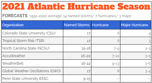
Beginning with this year’s hurricane season outlooks, NOAA’s Climate Prediction Center (CPC) will use 1991-2020 as the new 30-year period of record. The updated averages for the Atlantic hurricane season have increased with 14 named storms and 7 hurricanes. The average for major hurricanes (Category 3, 4 or 5) remains unchanged at 3. The previous Atlantic storm averages, based on the period from 1981 to 2010, were 12 named storms, 6 hurricanes, and 3 major hurricanes. NOAA is updating the set of statistics used to determine when hurricane seasons are above-, near-, or below-average relative to the climate record. This update process occurs once every decade.
LETS DIVE INTO EACH FORECAST...
NOTE: Based on a NEW 30-year average (1991-2020) a typical season has 14 named storms, seven hurricanes, and three major hurricanes.
Colorado State University (CSU) - ABOVE-AVERAGE SEASON - led by Dr. Phil Klotzbach they call for 17 named storms, 8 hurricanes and 4 major hurricanes. A major hurricane is one that is Category 3 or higher (115-plus-mph winds) on the Saffir-Simpson Hurricane Wind Scale. There's a 69% chance for at least one major hurricane to make landfall along U.S. shores, compared with an average over the last century of 52%, CSU researchers said. CSU bases this active season off the current weak La Niña conditions which may transition to neutral ENSO by this summer/fall and El Niño being unlikely. Entire forecast: http://tropical.colostate.edu/Forecast/2021-04.pdf
Tropical Storm Risk, Inc. (TSR) - ABOVE-AVERAGE SEASON - TSR raises its extended range forecast and predicts Atlantic hurricane activity in 2020 will be 25% above the long-term norm. The are calling for 17 named storms, 8 hurricanes and 3 major hurricanes. However, they note this outlook has large uncertainties. At present they estimate there is only a 25% chance that this enhanced activity will reach the hyperactive levels of hurricane activity seen in 2020. Entire forecast: http://www.tropicalstormrisk.com/docs/TSRATLForecastApr2021.pdf
Penn State ESSC - BELOW TO AVERAGE SEASON - PSU is the lone wolf calling for a below to average season and calls for 9 to 15 named storms this year. Their best estimate is 12 storms. The assumptions behind this forecast are the persistence of current North Atlantic Main Development Region (MDR) sea surface temperature (SST) anomalies throughout the 2021 hurricane season, the presence of neutral El Niño-Southern Oscillation (ENSO)-negative conditions by boreal late summer and early fall 2021 , and climatological mean conditions for the North Atlantic Oscillation in boreal fall/winter 2021-2022. Entire forecast: http://www.essc.psu.edu/essc_web/research/Hurricane2021.html
North Carolina State University (NCSU) - ABOVE-AVERAGE SEASON - The forecast from NCSU is predicting 15-18 named storms, 7 to 9 hurricanes and 2 to 3 of those to become major hurricanes. Lian Xie, professor of Marine, Earth, and Atmospheric Sciences at North Carolina State, believes The Gulf of Mexico will see an active hurricane season, though one more in line with historical averages, as Xie’s data indicate the likelihood of three to five named storms forming in the region, with two to four of them becoming hurricanes, and one becoming a major hurricane. Historic averages for the Gulf are three named storms and one hurricane.
AccuWeather.com - ABOVE-AVERAGE SEASON - AccuWeather is calling for 16-20 storms during this upcoming season. Of those storms, 7 to 10 are forecast to become hurricanes, and 3 to 5 are predicted to strengthen into major hurricanes. Led by Dan Kottlowksi, AccuWeather's top hurricane expert and fellow meteorologists are calling for the existing La Niña pattern to shift to an ENSO-neutral phase by the late spring or early summer which means water temperatures in this zone of the Pacific will be closer to average. The big question at this time is whether or not the pattern shifts back to a La Niña by the latter part of the hurricane season, according to Kottlowski. "If that happens, that could certainly increase the chance that we could see more than 20 storms,” he said. Entire forecast: http://www.accuweather.com/en/hurricane/accuweathers-2021-atlantic-hurricane-season-forecast/924431
WeatherBELL.com - ABOVE-AVERAGE SEASON - WeatherBell is also calling for 16-22 named storms, 9 to 13 hurricanes and 3 to 6 of those to strengthen into major hurricanes. They note this season the area on the western and central Gulf Coast is the focus of our highest impact along with the Carolinas. There is also a threat for above average impacts farther to the north up the East Coast and in South Florida. Entire forecast: http://www.weatherbell.com/april-2021-hurricane-forecast-update
Global Weather Oscillations (GWO) - ABOVE-AVERAGE SEASON - GWO's prediction calls for 17 named storms, 8 hurricanes and 3 to 4 major hurricanes. Professor Dilley says that “several factors are in place to produce another well above average hurricane season this year”. This includes a 72-year ClimatePulse Enhanced Hurricane Landfall Cycle that produces more United States landfalls - coupled with the lack of an El Niño that tends to subdue a hurricane season, and the continuance of warmer than normal water temperatures in the Caribbean, Gulf of Mexico and Atlantic. Entire forecast: http://www.globalweatheroscillations.com/
Global Weather Oscillations (GWO) - ABOVE-AVERAGE SEASON - GWO's prediction calls for 17 named storms, 8 hurricanes and 3 to 4 major hurricanes. Professor Dilley says that “several factors are in place to produce another well above average hurricane season this year”. This includes a 72-year ClimatePulse Enhanced Hurricane Landfall Cycle that produces more United States landfalls - coupled with the lack of an El Niño that tends to subdue a hurricane season, and the continuance of warmer than normal water temperatures in the Caribbean, Gulf of Mexico and Atlantic. Entire forecast: http://www.globalweatheroscillations.com/
Here are your 2021 Atlantic Hurricane Season Names: Ana, Bill, Claudette, Danny, Elsa, Fred, Grace, Henri, Ida, Julian, Kate, Larry, Mindy, Nicholas, Odette, Peter, Rose, Sam, Teresa, Victor and Wanda!!!
Note: There's no strong correlation between the number of storms or hurricanes and U.S. landfalls in any given season. One or more of the named storms forecast to develop this season could hit the U.S., or none at all. Therefore, residents of the coastal United States should prepare each year no matter the forecast.
A couple of classic examples of why you need to be prepared each year occurred in 1992 and 1983. The 1992 season produced only six named storms and one subtropical storm. However, one of those named storms was Hurricane Andrew, which devastated South Florida as a Category 5 hurricane. In 1983 there were only four named storms, but one of them was Alicia. The Category 3 hurricane hit the Houston-Galveston area and caused almost as many direct fatalities there as Andrew did in South Florida.
In contrast, the 2010 season was active. There were 19 named storms and 12 hurricanes that formed in the Atlantic Basin. Despite the large number of storms that year, not a single hurricane and only one tropical storm made landfall in the United States.
In other words, a season can deliver many storms, but have little impact, or deliver few storms and have one or more hitting the U.S. coast with major impact. So ALWAYS BE ALERT AND PREPARED NO MATTER WHAT THE FORECAST IS! You can rely on Track The Tropics EVERY YEAR to bring you the latest and most accurate information on Hurricane Season 24/7... STAY TUNED!!
Download Attachments Below
-
 2021 Hurricane Season Forecasts
File size: 28 KB Downloads: 1175