SHOW ME SOME LOVE AND SUPPORT
Website: TrackTheTropics.com/DONATE
Venmo: @TrackTheTropicsLouisiana
Cash App: Cash.App/$TrackTheTropics
Subscribe: FB.com/TrackTheTropics
Website: TrackTheTropics.com/DONATE
Venmo: @TrackTheTropicsLouisiana
Cash App: Cash.App/$TrackTheTropics
Subscribe: FB.com/TrackTheTropics

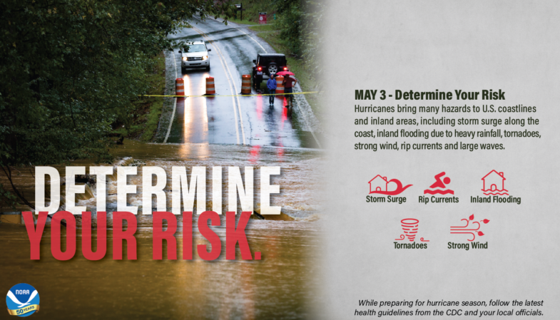
Find out today what types of wind and water hazards could happen where you live, and then start preparing now for how to handle them. Hurricanes are not just a coastal problem. Their impacts can be felt hundreds of miles inland. It’s easy to forget what a hurricane is capable of doing. In the past couple years the U.S. got a rude awakening to the impacts of Major Hurricanes such as Harvey in 2017 and Michael in 2018 and it is key to note that Hurricanes such as Ike, Sandy and Isaac reminded us that significant impacts can easily occur without it being a major hurricane. Also many people in Hurricane prone areas after years of no strikes can suffer from hurricane amnesia in the forms of complacency, denial and inexperience. You DO NOT want to get complacent! Hurricane Preparedness Week (May 3-9, 2020) is your time to prepare for a potential land-falling tropical storm or hurricane. BE PREPARED!
Thanks to NOAA for the above graphic and video!
One way to determine your risk is to check out the NOAA Coastal Services historical hurricane tracks tool
![[Map of return period in years for hurricanes passing within 50 nautical miles]](http://www.nhc.noaa.gov/climo/images/return_hurr.jpg) Estimated return period for hurricanes passing within 50 nautical miles of various locations on the U.S. Coast.
Estimated return period for hurricanes passing within 50 nautical miles of various locations on the U.S. Coast.
![[Map of return period in years for major hurricanes passing within 50 nautical miles]](http://www.nhc.noaa.gov/climo/images/return_mjrhurr.jpg) Estimated return period for major hurricanes passing within 50 nautical miles of various locations on the U.S. Coast.
Estimated return period for major hurricanes passing within 50 nautical miles of various locations on the U.S. Coast.
CONUS Hurricane Strikes
1950-2017 CONUS Hurricane Strikes
Below we go deeper into determining your risks and this information is located 24-7 on my site at Tropical Cyclones 101. ALWAYS stay prepared!
Each year beginning around June 1st, the Gulf and East Coast states are at great risk for tropical cyclones. While most people know that tropical cyclones can contain damaging wind, many do not realize that they also produce several other hazards, both directly and indirectly. Following is vital information you need to help minimize the impact of tropical cyclones on you and your loved ones. This is your call to action.
 In addition, wind driven waves are superimposed on the storm tide. This rise in water level can cause severe flooding in coastal areas, particularly when the storm tide coincides with the normal high tides. Because much of the United States' densely populated Atlantic and Gulf Coast coastlines lie less than 10 feet above mean sea level, the danger from storm tides is tremendous.
The level of surge in a particular area is also determined by the slope of the continental shelf. A shallow slope off the coast will allow a greater surge to inundate coastal communities. Communities with a steeper continental shelf will not see as much surge inundation, although large breaking waves can still present major problems. Storm tides, waves, and currents in confined harbors severely damage ships, marinas, and pleasure boats.
Gusts are short but rapid bursts in wind speed and are primarily caused by turbulence over land mixing faster air aloft to the surface. Squalls, on the other hand, are longer periods of increased wind speeds and are generally associated with the bands of thunderstorms which make-up the spiral bands around the hurricane.
 A tropical cyclone's wind damages and destroys structures two ways. First, many homes are damaged or destroyed when the high wind simply lifts the roof off of the dwellings. The process involved is called Bernoulli's Principle which implies the faster the air moves the lower the pressure within the air becomes. The high wind moving over the top of the roof creates lower pressure on the exposed side of the roof relative to the attic side.
The higher pressure in the attic helps lift the roof. Once lifted, the roof acts as a sail and is blown clear of the dwelling. With the roof gone, the walls are much easier to be blown down by the hurricane's wind.
The second way the wind destroys buildings can also be a result of the roof becoming airborne. The wind picks up the debris (i.e. wood, metal siding, toys, trash cans, tree branches, etc.) and sends them hurling at high speeds into other structures. Based on observations made during damage investigations conducted by the Wind Science and Engineering Research Center at Texas Tech University, researchers realized that much of the damage in windstorms is caused by flying debris.
They found, based on damage investigations, sections of wooden planks are the most typical type of debris observed due to tornado. A 15-lb 2x4 timber plank in a 250 mph (400 km/h) wind would travel at 100 mph (161 km/h). While 250 mph (400 km/h) is considerably more than even the strongest hurricane's sustained wind, the wind in squalls and tornadoes, could easily reach that speed.
 In addition to the storm surge and high winds, tropical cyclones threaten the United States with their torrential rains and flooding. Even after the wind has diminished, the flooding potential of these storms remains for several days.
Since 1970, nearly 60% of the 600 deaths due to floods associated with tropical cyclones occurred inland from the storm's landfall. Of that 60%, almost a fourth (23%) of U.S. tropical cyclone deaths occur to people who drown in, or attempting to abandon, their cars.
Also, over three-fourths (78%) of children killed by tropical cyclones drowned in freshwater floods. In fact, more people are killed by floods than any other weather related cause. Most of these fatalities occur because people underestimate the power of moving water and purposely walk or drive into flooding conditions.
It is common to think the stronger the storm the greater the potential for flooding. However, this is not always the case. A weak, slow moving tropical storm can cause more damage due to flooding than a more powerful fast moving hurricane. This was very evident with Tropical Storm Allison in June 2001.
 Allison, the first named storm of the 2001 Atlantic Hurricane Season, devastated portions of Southeast Texas, including the Houston Metro area and surrounding communities, with severe flooding. Allison spent five days over Southeast and East Texas and dumped record amounts of rainfall across the area. Allison deposited up to three feet of rain to the east and northeast of Houston, Texas during a 5-day period. This map of Harris County shows the heaviest rainfall distribution.
In addition to the storm surge, tropical cyclones can, and usually do, cause several types of flooding.
Allison, the first named storm of the 2001 Atlantic Hurricane Season, devastated portions of Southeast Texas, including the Houston Metro area and surrounding communities, with severe flooding. Allison spent five days over Southeast and East Texas and dumped record amounts of rainfall across the area. Allison deposited up to three feet of rain to the east and northeast of Houston, Texas during a 5-day period. This map of Harris County shows the heaviest rainfall distribution.
In addition to the storm surge, tropical cyclones can, and usually do, cause several types of flooding.
Rip currents are channeled currents of water flowing away from shore, usually extending past the line of breaking waves, that can pull even the strongest swimmers away from shore.
In 2008, despite the fact that Hurricane Bertha was more than a 1,000 miles offshore, the storm resulted in rip currents that killed three people along the New Jersey coast and required 1,500 lifeguard rescues in Ocean City, Maryland, over a 1 week period.
In 2009, all six deaths in the United States directly attributable to tropical cyclones occurred as the result of drowning from large waves or strong rip currents.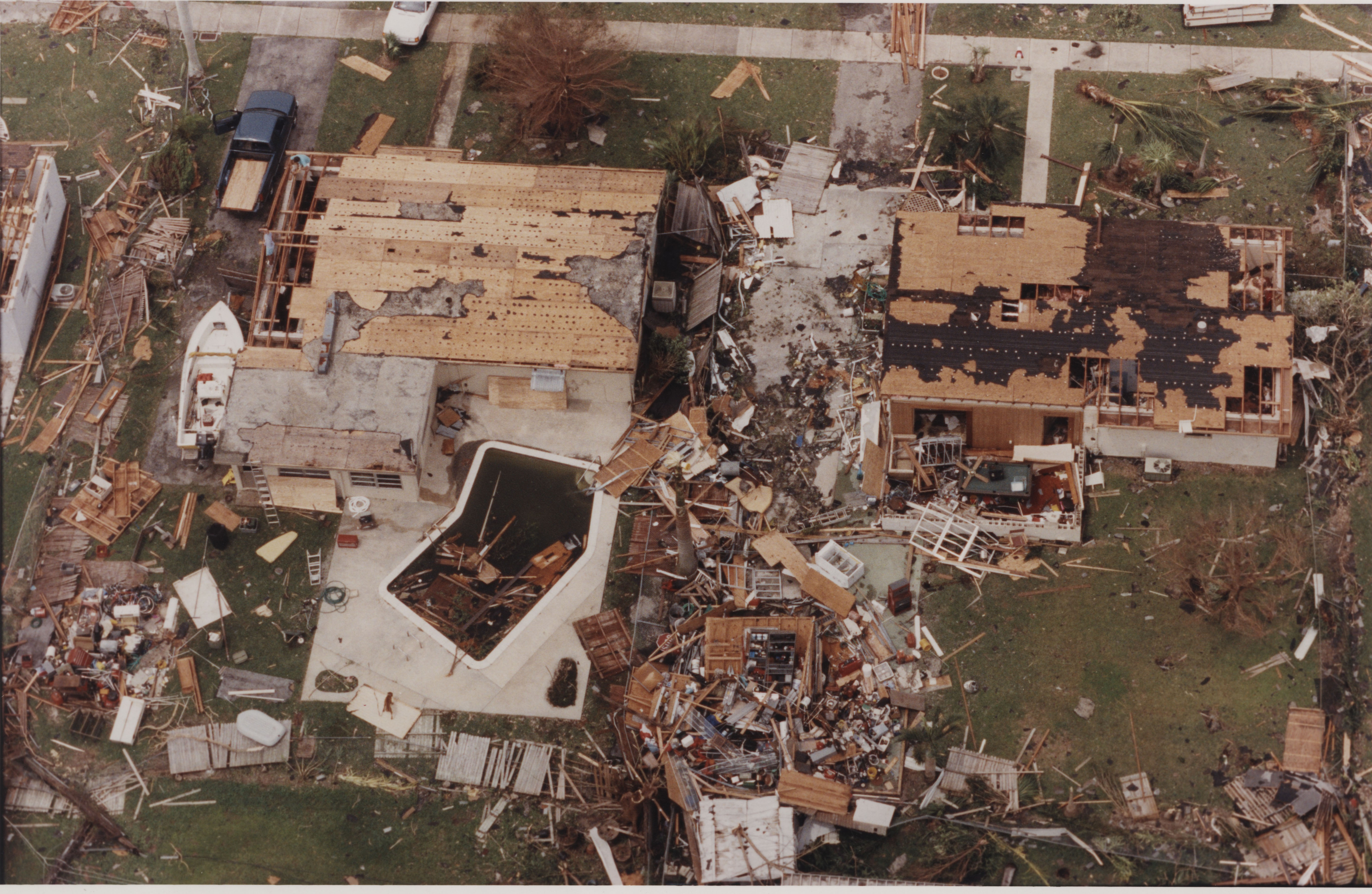 Tropical cyclones can also produce tornadoes that add to the storm's destructive power. Tornadoes are most likely to occur in the right-front quadrant of the hurricane relative to its motion. However, they are also often found elsewhere embedded in the rain bands, well away from the center of the tropical cyclones.
Tornadoes are thought responsible for the uneven damage seen in a hurricane's aftermath. The photo (right) shows the total destruction of two buildings in the center of a complex of similar buildings. The added strength of wind combined with the tornadoes twisting motion greatly intensifies the destruction.
Some tropical cyclones seem to produce no tornadoes, while others develop multiple ones. Studies have shown that more than half of the land falling hurricanes produce at least one tornado; Hurricane Buelah (1967) spawned 141 according to one study. In general, tornadoes associated with hurricanes are less intense than those that occur in the Great Plains. Nonetheless, the effects of tornadoes, added to the larger area of hurricane-force winds, can produce substantial damage.

Thanks to NOAA for the above graphic and video!
One way to determine your risk is to check out the NOAA Coastal Services historical hurricane tracks tool
Estimated return period for hurricanes passing within 50 nautical miles of various locations on the U.S. Coast.
Estimated return period for major hurricanes passing within 50 nautical miles of various locations on the U.S. Coast.CONUS Hurricane Strikes
![[Map of 1950-2017 CONUS Hurricane Strikes]](http://www.nhc.noaa.gov/climo/images/conus_strikes.jpg)
1950-2017 CONUS Hurricane Strikes
Below we go deeper into determining your risks and this information is located 24-7 on my site at Tropical Cyclones 101. ALWAYS stay prepared!
Each year beginning around June 1st, the Gulf and East Coast states are at great risk for tropical cyclones. While most people know that tropical cyclones can contain damaging wind, many do not realize that they also produce several other hazards, both directly and indirectly. Following is vital information you need to help minimize the impact of tropical cyclones on you and your loved ones. This is your call to action.
Storm Surge
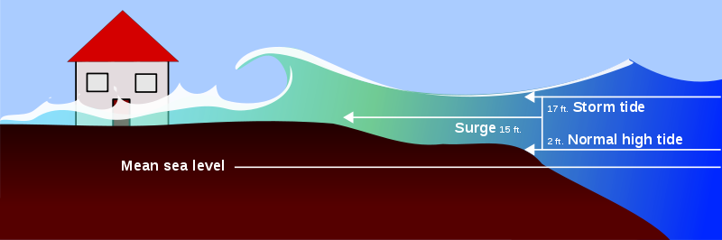
Storm surge is simply water that is pushed toward the shore by the force of the winds swirling around the storm. This advancing surge combines with the normal tides to create the hurricane storm tide, which can increase the average water level 15 feet (4.5 m) or more.In addition, wind driven waves are superimposed on the storm tide. This rise in water level can cause severe flooding in coastal areas, particularly when the storm tide coincides with the normal high tides. Because much of the United States' densely populated Atlantic and Gulf Coast coastlines lie less than 10 feet above mean sea level, the danger from storm tides is tremendous.
The level of surge in a particular area is also determined by the slope of the continental shelf. A shallow slope off the coast will allow a greater surge to inundate coastal communities. Communities with a steeper continental shelf will not see as much surge inundation, although large breaking waves can still present major problems. Storm tides, waves, and currents in confined harbors severely damage ships, marinas, and pleasure boats.
Wind and Squalls
Hurricanes are known for their damaging wind. They are rated in strength by their wind also. However, when the NWS's National Hurricane Center issues a statement concerning the wind and category, that value is for sustained wind only. This hurricane scale does not include gusts or squalls.Gusts are short but rapid bursts in wind speed and are primarily caused by turbulence over land mixing faster air aloft to the surface. Squalls, on the other hand, are longer periods of increased wind speeds and are generally associated with the bands of thunderstorms which make-up the spiral bands around the hurricane.
A tropical cyclone's wind damages and destroys structures two ways. First, many homes are damaged or destroyed when the high wind simply lifts the roof off of the dwellings. The process involved is called Bernoulli's Principle which implies the faster the air moves the lower the pressure within the air becomes. The high wind moving over the top of the roof creates lower pressure on the exposed side of the roof relative to the attic side.
The higher pressure in the attic helps lift the roof. Once lifted, the roof acts as a sail and is blown clear of the dwelling. With the roof gone, the walls are much easier to be blown down by the hurricane's wind.
The second way the wind destroys buildings can also be a result of the roof becoming airborne. The wind picks up the debris (i.e. wood, metal siding, toys, trash cans, tree branches, etc.) and sends them hurling at high speeds into other structures. Based on observations made during damage investigations conducted by the Wind Science and Engineering Research Center at Texas Tech University, researchers realized that much of the damage in windstorms is caused by flying debris.
They found, based on damage investigations, sections of wooden planks are the most typical type of debris observed due to tornado. A 15-lb 2x4 timber plank in a 250 mph (400 km/h) wind would travel at 100 mph (161 km/h). While 250 mph (400 km/h) is considerably more than even the strongest hurricane's sustained wind, the wind in squalls and tornadoes, could easily reach that speed.
Inland Flooding
In addition to the storm surge and high winds, tropical cyclones threaten the United States with their torrential rains and flooding. Even after the wind has diminished, the flooding potential of these storms remains for several days.
Since 1970, nearly 60% of the 600 deaths due to floods associated with tropical cyclones occurred inland from the storm's landfall. Of that 60%, almost a fourth (23%) of U.S. tropical cyclone deaths occur to people who drown in, or attempting to abandon, their cars.
Also, over three-fourths (78%) of children killed by tropical cyclones drowned in freshwater floods. In fact, more people are killed by floods than any other weather related cause. Most of these fatalities occur because people underestimate the power of moving water and purposely walk or drive into flooding conditions.
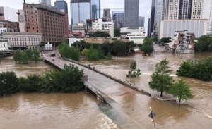
It is common to think the stronger the storm the greater the potential for flooding. However, this is not always the case. A weak, slow moving tropical storm can cause more damage due to flooding than a more powerful fast moving hurricane. This was very evident with Tropical Storm Allison in June 2001.
Allison, the first named storm of the 2001 Atlantic Hurricane Season, devastated portions of Southeast Texas, including the Houston Metro area and surrounding communities, with severe flooding. Allison spent five days over Southeast and East Texas and dumped record amounts of rainfall across the area. Allison deposited up to three feet of rain to the east and northeast of Houston, Texas during a 5-day period. This map of Harris County shows the heaviest rainfall distribution.
In addition to the storm surge, tropical cyclones can, and usually do, cause several types of flooding.- Flash flooding
- Flash floods are rapid occurring events. This type of flood can begin within a few minutes or hours of excessive rainfall. The rapidly rising water can reach heights of 30 feet (10 m) or more and can roll boulders, rip trees from the ground, and destroy buildings and bridges.
- Urban/Area floods
- Urban/Area floods are also rapid events although not quite as severe as a flash flood. Still, streets can become swift-moving rivers and basements can become death traps as they fill with water. The primary cause is due to the conversion of fields or woodlands to roads and parking lots. About 10% of the land in the United States is paved roads. So, water that would have been absorbed into the ground now runs into storm drains and sewers.
- River flooding
- River floods are longer term events and occur when the runoff from torrential rains, brought on by decaying hurricanes or tropical storms, reach the rivers. A lot of the excessive water in river floods may have began as flash floods. River floods can occur in just a few hours and also last a week or longer.
Rip Currents
The strong winds of a tropical cyclone can cause dangerous waves that pose a significant hazard to mariners and coastal residents and visitors. When the waves break along the coast, they can produce deadly rip currents - even at large distances from the storm.Rip currents are channeled currents of water flowing away from shore, usually extending past the line of breaking waves, that can pull even the strongest swimmers away from shore.
In 2008, despite the fact that Hurricane Bertha was more than a 1,000 miles offshore, the storm resulted in rip currents that killed three people along the New Jersey coast and required 1,500 lifeguard rescues in Ocean City, Maryland, over a 1 week period.
In 2009, all six deaths in the United States directly attributable to tropical cyclones occurred as the result of drowning from large waves or strong rip currents.
Find out more about rip currents on the NWS Rip Current Safety page.
Tornadoes
Tropical cyclones can also produce tornadoes that add to the storm's destructive power. Tornadoes are most likely to occur in the right-front quadrant of the hurricane relative to its motion. However, they are also often found elsewhere embedded in the rain bands, well away from the center of the tropical cyclones.
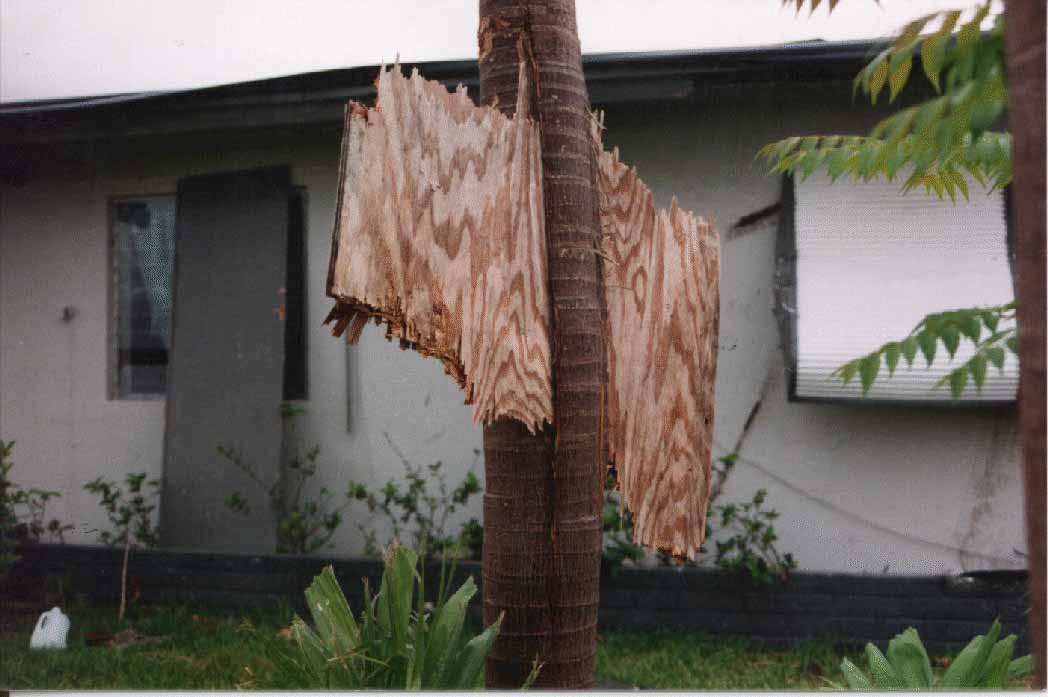
Tornadoes are thought responsible for the uneven damage seen in a hurricane's aftermath. The photo (right) shows the total destruction of two buildings in the center of a complex of similar buildings. The added strength of wind combined with the tornadoes twisting motion greatly intensifies the destruction.
Some tropical cyclones seem to produce no tornadoes, while others develop multiple ones. Studies have shown that more than half of the land falling hurricanes produce at least one tornado; Hurricane Buelah (1967) spawned 141 according to one study. In general, tornadoes associated with hurricanes are less intense than those that occur in the Great Plains. Nonetheless, the effects of tornadoes, added to the larger area of hurricane-force winds, can produce substantial damage.
- When associated with hurricanes, tornadoes are not usually accompanied by hail or a lot of lightning.
- Tornadoes can occur for days after landfall when the tropical cyclone remnants maintain an identifiable low pressure circulation.
- They can also develop at any time of the day or night during landfall. However, by 12 hours after landfall, tornadoes tend to occur mainly during daytime hours.