266 Visitors Tracking The Tropics!
PLEASE SUPPORT TRACK THE TROPICS
Track The Tropics is the #1 source to track the tropics 24/7! Since 2013 the main goal of the site is to bring all of the important links and graphics to ONE PLACE so you can keep up to date on any threats to land during the Atlantic Hurricane Season! Hurricane Season 2026 in the Atlantic starts on June 1st and ends on November 30th. Do you love Spaghetti Models? Well you've come to the right place!! Remember when you're preparing for a storm: Run from the water; hide from the wind!
Tropical Atlantic Weather Resources
- NOAA National Hurricane Center
- International Meteorology Database
- FSU Tropical Cyclone Track Probabilities
- Brian McNoldy Atlantic Headquarters
- Brian McNoldy Tropical Satellite Sectors
- Brian McNoldy Infrared Hovmoller
- Brian McNoldy Past TC Radar Loops
- Weather Nerds TC Guidance
- Twister Data Model Guidance
- NOAA Tropical Cyclone Tracks
- Albany GFS/ EURO Models/ Ensembles
- Albany Tropical Cyclone Guidance
- Albany Tropical Atlantic Model Maps
- Pivotal Weather Model Guidance
- Weather Online Model Guidance
- UKMet Model Guidance/ Analysis/ Sat
- ECMWF (EURO) Model Guidance
- FSU Tropical Model Outputs
- FSU Tropical Cyclone Genesis
- Penn State Tropical E-Wall
- NOAA HFIP Ruc Models
- Navy NRL TC Page
- College of DuPage Model Guidance
- WXCharts Model Guidance
- NOAA NHC Analysis Tools
- NOAA NHC ATCF Directory
- NOAA NCEP/EMC Cyclogenesis Tracking
- NOAA NCEP/EMC HWRF Model
- NOAA HFIP Model Products
- University of Miami Ocean Heat
- COLA Max Potential Hurricane Intensity
- Colorado State RAMMB TC Tracking
- Colorado State RAMMB Floaters
- Colorado State RAMMB GOES-16 Viewer
- NOAA NESDIS GOES Satellite
- ASCAT Ocean Surface Winds METOP-A
- ASCAT Ocean Surface Winds METOP-B
- Michael Ventrice Waves / MJO Maps
- TropicalAtlantic.com Analysis / Recon
- NCAR/RAL Tropical Cyclone Guidance
- CyclonicWX Tropical Resources
Historic Louisiana Storms By Month
January
June
July
August
September
October
Hurricane Preparedness: Assemble Disaster Supplies
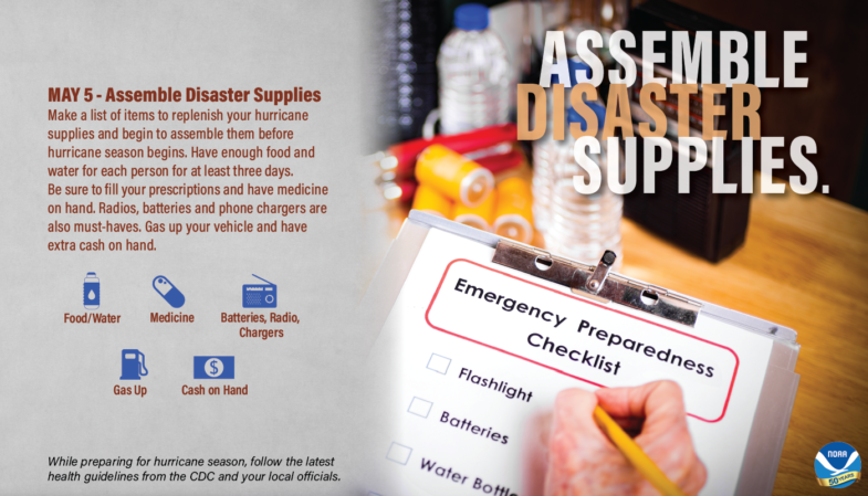
You’re going to need supplies not just to get through the storm but for the potentially lengthy and unpleasant aftermath. Have enough non-perishable food, water and medicine to last each person in your family a minimum of 3 days. Electricity and water could be out for at least that long. You’ll need extra cash, a battery-powered radio and flashlights. Many of us have cell phones, and they all run on batteries. You’re going to need a portable, crank or solar powered USB charger.

Thanks to NOAA for the above graphic and video!
Below we list a plan and checklist on disaster supplies... thanks to FLASH for the information!
What to Plan For
You'll need to plan for two situations: Remaining in your home after a disaster or evacuating to a safer location.
Have a three-day supply of food and water on hand -- plan for one gallon of water per person per day and food that won't spoil.
Keep a manual can opener and emergency tools including a fire extinguisher, battery-powered radio, flashlight and plenty of batteries.
Disaster Supply Checklist
Be sure to gather the following items to ensure your family's basic comfort and well-being in case of evacuation.
Keep Your Kit Fresh
Remember to replace stored food and water every six months, keep a supply of fresh batteries on hand and keep your most important up-to-date family papers in a fire and water proof container.
The Importance of Water
Stocking an emergency water supply should be one of your top priorities so you will have enough water on hand for yourself and your family.
While individual needs will vary depending on age, physical condition, activity, diet and climate, a normally active person needs at least two quarts of drinking water daily. Children, nursing mothers and people who are ill need more water.
Very hot temperatures can also double the amount of water needed. Because you will also need water for sanitary purposes, and possibly for cooking, you should store at least one gallon of water per person per day.
When storing water, use thoroughly washed plastic, fiberglass or enamel-lined containers. Don't use containers that can break, such as glass bottles. Never use a container that has held toxic substances. Camping supply stores offer a variety of appropriate containers.
Plastic containers, like soda bottles, are best. Seal your water containers tightly, label them and store them in a cool, dark place. It is important to change stored water every six months.

Thanks to NOAA for the above graphic and video!
Below we list a plan and checklist on disaster supplies... thanks to FLASH for the information!
What to Plan For
You'll need to plan for two situations: Remaining in your home after a disaster or evacuating to a safer location.
Have a three-day supply of food and water on hand -- plan for one gallon of water per person per day and food that won't spoil.
Keep a manual can opener and emergency tools including a fire extinguisher, battery-powered radio, flashlight and plenty of batteries.
Disaster Supply Checklist
Be sure to gather the following items to ensure your family's basic comfort and well-being in case of evacuation.
- Cash -- Banks and ATMs may not be open or available for extended periods.
- Water -- at least one gallon per person per day for three to seven days, plus water for pets.
- Food -- at least enough for three to seven days, including: Non-perishable packaged or canned food and juices, food for infants and the elderly, snack food, non-electric can opener, vitamins, paper plates, plastic utensils.
- Radio -- battery powered and NOAA weather radio with extra batteries.
- Blankets, pillows etc.
- Clothing -- seasonal, rain gear/ sturdy shoes.
- First Aid Kit -- plus medicines, prescription drugs.
- Special items -- for babies and the elderly.
- Toiletries -- hygiene items, moisture wipes, sanitizer.
- Flashlight and batteries.
- Keys.
- Toys, books, games.
- Pet care items, proper identification, immunization records, ample food and water, medicine, a carrier or cage, leash.
- Insurance papers
- Medical records
- Bank account numbers
- Social Security cards
- Deeds or mortgages
- Birth and marriage certificates
- Stocks and bonds
- Recent tax returns
- Wills
Keep Your Kit Fresh
Remember to replace stored food and water every six months, keep a supply of fresh batteries on hand and keep your most important up-to-date family papers in a fire and water proof container.
The Importance of Water
Stocking an emergency water supply should be one of your top priorities so you will have enough water on hand for yourself and your family.
While individual needs will vary depending on age, physical condition, activity, diet and climate, a normally active person needs at least two quarts of drinking water daily. Children, nursing mothers and people who are ill need more water.
Very hot temperatures can also double the amount of water needed. Because you will also need water for sanitary purposes, and possibly for cooking, you should store at least one gallon of water per person per day.
When storing water, use thoroughly washed plastic, fiberglass or enamel-lined containers. Don't use containers that can break, such as glass bottles. Never use a container that has held toxic substances. Camping supply stores offer a variety of appropriate containers.
Plastic containers, like soda bottles, are best. Seal your water containers tightly, label them and store them in a cool, dark place. It is important to change stored water every six months.
Complete Hurricane Preparedness Guide:
Determine Your Risk
Develop An Evacuation Plan
Assemble Disaster Supplies
Secure An Insurance Checkup
Strengthen Your Home
Check On Your Neighbor
Complete Your Written Hurricane Plan
Develop An Evacuation Plan
Assemble Disaster Supplies
Secure An Insurance Checkup
Strengthen Your Home
Check On Your Neighbor
Complete Your Written Hurricane Plan

 DONATE
