276 Visitors Tracking The Tropics!
SHOW ME SOME LOVE AND SUPPORT
Website: TrackTheTropics.com/DONATE
Venmo: @TrackTheTropicsLouisiana
Cash App: Cash.App/$TrackTheTropics
Subscribe: FB.com/TrackTheTropics
Website: TrackTheTropics.com/DONATE
Venmo: @TrackTheTropicsLouisiana
Cash App: Cash.App/$TrackTheTropics
Subscribe: FB.com/TrackTheTropics

Track The Tropics is the #1 source to track the tropics 24/7! Since 2013 the main goal of the site is to bring all of the important links and graphics to ONE PLACE so you can keep up to date on any threats to land during the Atlantic Hurricane Season! Hurricane Season 2026 in the Atlantic starts on June 1st and ends on November 30th. Do you love Spaghetti Models? Well you've come to the right place!! Remember when you're preparing for a storm: Run from the water; hide from the wind!
Tropical Atlantic Weather Resources
- NOAA National Hurricane Center
- International Meteorology Database
- FSU Tropical Cyclone Track Probabilities
- Brian McNoldy Atlantic Headquarters
- Brian McNoldy Tropical Satellite Sectors
- Brian McNoldy Infrared Hovmoller
- Brian McNoldy Past TC Radar Loops
- Weather Nerds TC Guidance
- Twister Data Model Guidance
- NOAA Tropical Cyclone Tracks
- Albany GFS/ EURO Models/ Ensembles
- Albany Tropical Cyclone Guidance
- Albany Tropical Atlantic Model Maps
- Pivotal Weather Model Guidance
- Weather Online Model Guidance
- UKMet Model Guidance/ Analysis/ Sat
- ECMWF (EURO) Model Guidance
- FSU Tropical Model Outputs
- FSU Tropical Cyclone Genesis
- Penn State Tropical E-Wall
- NOAA HFIP Ruc Models
- Navy NRL TC Page
- College of DuPage Model Guidance
- WXCharts Model Guidance
- NOAA NHC Analysis Tools
- NOAA NHC ATCF Directory
- NOAA NCEP/EMC Cyclogenesis Tracking
- NOAA NCEP/EMC HWRF Model
- NOAA HFIP Model Products
- University of Miami Ocean Heat
- COLA Max Potential Hurricane Intensity
- Colorado State RAMMB TC Tracking
- Colorado State RAMMB Floaters
- Colorado State RAMMB GOES-16 Viewer
- NOAA NESDIS GOES Satellite
- ASCAT Ocean Surface Winds METOP-A
- ASCAT Ocean Surface Winds METOP-B
- Michael Ventrice Waves / MJO Maps
- TropicalAtlantic.com Analysis / Recon
- NCAR/RAL Tropical Cyclone Guidance
- CyclonicWX Tropical Resources
Historic Louisiana Storms By Month
January
June
July
August
September
October
2019 Hurricane Season Forecasts
The 2019 hurricane season begins June 1st!
Before the 2018 hurricane season started, Most forecasting groups called for a below-average season due to cooler than normal sea surface temperatures in the tropical Atlantic and the anticipated development of an El Niño. However, the anticipated El Niño failed to develop in time to suppress activity, and activity exceeded most predictions. The 2018 Atlantic hurricane season was the third in a consecutive series of above-average and damaging Atlantic hurricane seasons, featuring 15 named storms, 8 hurricanes, and 2 major hurricanes, which caused a total of over $49.975 billion (2018 USD) in damages. The season officially began on June 1, 2018, and ended on November 30, 2018. These dates historically describe the period each year when most tropical cyclones form in the Atlantic basin and are adopted by convention. The formation of Tropical Storm Alberto on May 25, marked the fourth consecutive year in which a storm developed before the official start of the season. The next storm, Beryl, became the first hurricane to form in the eastern Atlantic during the month of July since Bertha in 2008. Chris, upgraded to a hurricane on July 10, became the earliest second hurricane in a season since 2005. No hurricanes formed in the North Atlantic during the month of August, marking the first season since 2013, and the eighth season on record, to do so. On September 5, Florence became the first major hurricane of the season. On September 12, Joyce formed, making 2018 the first season since 2008 to feature four named storms active simultaneously (Florence, Helene, Isaac, and Joyce). On October 9, Michael became the second major hurricane of the season, and a day later, it became the third-most intense hurricane to make landfall on the United States in terms of pressure, behind the 1935 Labor Day hurricane and Hurricane Camille of 1969. With the formation of Oscar on October 26, the season is the first on record to see seven storms that were subtropical at some point in their lifetimes (Alberto, Beryl, Debby, Ernesto, Joyce, Leslie, and Oscar).
Below are the latest 2019 seasonal forecasts from all of the major organizations...
UPDATED AS OF 5-6-2019
The 2019 Atlantic hurricane season is an upcoming event in the annual formation of tropical cyclones in the Northern Hemisphere. The season will officially begin on June 1, 2019, and end on November 30, 2019. These dates historically describe the period each year when most tropical cyclones form in the Atlantic basin and are adopted by convention. However, tropical cyclogenesis is possible at any time of the year.
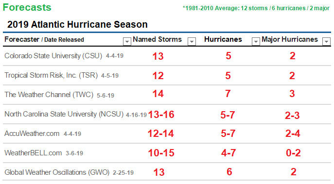
Colorado State University (CSU) is forecasting a NEAR AVERAGE Season with a total of 13 named storms, 5 hurricanes which 2 of those will be major hurricanes and an Accumulated Cyclone Energy (ACE) of 80. The CSU outlook also calls for a 48% chance of a major hurricane hitting the U.S. in 2019, with a 28% chance for the East Coast and Florida Peninsula and a 28% chance for the Gulf Coast. The Caribbean is forecast to have a 39% chance of seeing at least one major hurricane. The forecast prepared by the CSU Tropical Meteorology Project, headed by Dr. Phil Klotzbach is NEAR the 30 year average from 1981 - 2010. They are saying the current weak El Niño event appears likely to maintain intensity or perhaps even strengthen during the summer/fall.
Tropical Storm Risk, Inc. (TSR) is forecasting a slightly BELOW AVERAGE Season with a total of 12 named storms, 5 hurricanes which 2 of those will be major hurricanes. ACE index at an 81. TSR’s main predictor is the forecasted July-September trade wind speed over the Caribbean Sea and tropical North Atlantic. This parameter influences cyclonic vorticity (the spinning up of storms) and vertical wind shear in the main hurricane track region (MDR). At present TSR anticipates that the July-September trade wind speed in 2019 will be slightly stronger than normal - due mainly to a continuance of weak-to-moderate El Niño conditions - and that this will have a suppressing effect on North Atlantic hurricane activity in 2019.
The Weather Channel's (TWC) is forecasting a slightly ABOVE AVERAGE Season with a total of 14 named storms, 7 hurricanes which 3 of those will be major hurricanes. The Weather Company's outlook is based on a number of factors, including sea-surface temperatures in the Atlantic Ocean, El Niño and other teleconnections, statistical computer forecast model guidance and past hurricane seasons exhibiting similar atmospheric conditions.
North Carolina State University (NCSU) is forecasting a slightly ABOVE AVERAGE Season. According to Lian Xie, professor of marine, earth and atmospheric sciences at NC State, they are calling for a total of 13-16 named storms, 5-7 hurricanes which 2-3 of those will be major hurricanes. For the Gulf of Mexico, Xie’s data indicates the likelihood of 4-7 named storms forming in the region, with 1-2 of the storms becoming a hurricane. Historic averages for the Gulf are three named storms and one hurricane. Xie’s methodology evaluates more than 100 years of historical data on Atlantic Ocean hurricane positions and intensity, as well as other variables, including weather patterns and sea-surface temperatures, to predict how many storms will form in each ocean basin. Xie notes that this year, the potential for the ongoing weak El Niño to strengthen injected significant uncertainty into the forecast.
AccuWeather.com is forecasting an AVERAGE TO SLIGHTLY ABOVEaverage Season with 12-14 named storms, 5-7 of which are projected to become hurricanes and 2-4 of which may become major hurricanes. They think this year will be not quite as active as last year BUT even an average or below-average season can produce a catastrophic storm. Forecasters are fond of pointing out that the “quiet” hurricane season of 1992 produced Hurricane Andrew.
WeatherBELL.com is forecasting in between a BELOW to ABOVE average Season with 10-15 named storms, 4-7 hurricanes which 0-2 of those becoming major hurricanes and an Accumulated Cyclone Energy (ACE) of 60-110. WeatherBELL says if the El Niño isn't impressive we could see activity in line with last year, hence the relatively broad range.
Global Weather Oscillations (GWO) is forecasting a slightly ABOVE AVERAGE Season with a total of 13 named storms, 6 hurricanes which 2 of those will be major hurricanes. In the last decade Florida based prediction organization GWO has consistently predicted the landfalls of major storms like Hurricane Harvey, Irma, Maria and Michael with a laser-like focus, seemingly outsmarting other storm prediction organizations. For the last 10 years former NOAA Meteorologist Professor David Dilley has issued the most accurate preseason and in-season hurricane predictions, averaging a stunning 87%+ accuracy rate. GWO mentions the upcoming hurricane season will likely be just as destructive and costly as the 2017 and 2018 hurricane seasons – with two major impact hurricanes likely this year.
Here are the official 2019 Names: Andrea, Barry, Chantal, Dean, Erin, Fernand, Gabrielle, Humberto, Imelda, Jerry, Karen, Lorenzo, Melissa, Nestor, Olga, Pablo, Rebekah, Sebastien, Tanya, Van and Wendy!!!
Note: There is no strong correlation between the number of storms or hurricanes and U.S. landfalls in any given season. One or more of the named storms forecast to develop this season could hit the U.S., or none at all. Therefore, residents of the coastal United States should prepare each year no matter the forecast.
A couple of classic examples of why you need to be prepared each year occurred in 1992 and 1983. The 1992 season produced only six named storms and one subtropical storm. However, one of those named storms was Hurricane Andrew, which devastated South Florida as a Category 5 hurricane. In 1983 there were only four named storms, but one of them was Alicia. The Category 3 hurricane hit the Houston-Galveston area and caused almost as many direct fatalities there as Andrew did in South Florida.
In contrast, the 2010 season was active. There were 19 named storms and 12 hurricanes that formed in the Atlantic Basin. Despite the large number of storms that year, not a single hurricane and only one tropical storm made landfall in the United States.
In other words, a season can deliver many storms, but have little impact, or deliver few storms and have one or more hitting the U.S. coast with major impact. So ALWAYS BE ALERT AND PREPARED NO MATTER WHAT THE FORECAST IS! You can rely on Track The Tropics EVERY YEAR to bring you the latest and most accurate information on Hurricane Season 24/7... STAY TUNED!!
Tagged 2019, Active, Average, Below Average, forecast, Hurricane, Hurricane Season, Names, Season, Track The Tropics, Tropical, Tropical Storm, Tropics