163 Visitors Tracking The Tropics!
PLEASE SUPPORT TRACK THE TROPICS
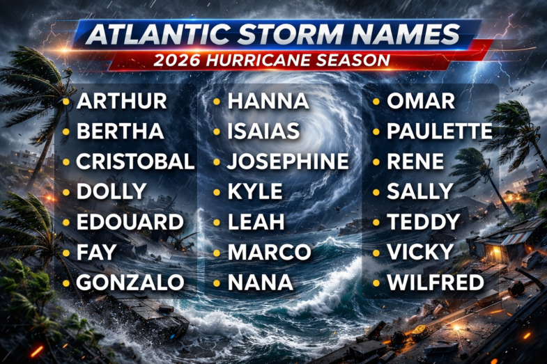
Track The Tropics is the #1 source to track the tropics 24/7! Since 2013 the main goal of the site is to bring all of the important links and graphics to ONE PLACE so you can keep up to date on any threats to land during the Atlantic Hurricane Season! Hurricane Season 2026 in the Atlantic starts on June 1st and ends on November 30th. Do you love Spaghetti Models? Well you've come to the right place!! Remember when you're preparing for a storm: Run from the water; hide from the wind!
Tropical Atlantic Weather Resources
- NOAA National Hurricane Center
- International Meteorology Database
- FSU Tropical Cyclone Track Probabilities
- Brian McNoldy Atlantic Headquarters
- Brian McNoldy Tropical Satellite Sectors
- Brian McNoldy Infrared Hovmoller
- Brian McNoldy Past TC Radar Loops
- Weather Nerds TC Guidance
- Twister Data Model Guidance
- NOAA Tropical Cyclone Tracks
- Albany GFS/ EURO Models/ Ensembles
- Albany Tropical Cyclone Guidance
- Albany Tropical Atlantic Model Maps
- Pivotal Weather Model Guidance
- Weather Online Model Guidance
- UKMet Model Guidance/ Analysis/ Sat
- ECMWF (EURO) Model Guidance
- FSU Tropical Model Outputs
- FSU Tropical Cyclone Genesis
- Penn State Tropical E-Wall
- NOAA HFIP Ruc Models
- Navy NRL TC Page
- College of DuPage Model Guidance
- WXCharts Model Guidance
- NOAA NHC Analysis Tools
- NOAA NHC ATCF Directory
- NOAA NCEP/EMC Cyclogenesis Tracking
- NOAA NCEP/EMC HWRF Model
- NOAA HFIP Model Products
- University of Miami Ocean Heat
- COLA Max Potential Hurricane Intensity
- Colorado State RAMMB TC Tracking
- Colorado State RAMMB Floaters
- Colorado State RAMMB GOES-16 Viewer
- NOAA NESDIS GOES Satellite
- ASCAT Ocean Surface Winds METOP-A
- ASCAT Ocean Surface Winds METOP-B
- Michael Ventrice Waves / MJO Maps
- TropicalAtlantic.com Analysis / Recon
- NCAR/RAL Tropical Cyclone Guidance
- CyclonicWX Tropical Resources
Historic Louisiana Storms By Month
January
June
July
August
September
October
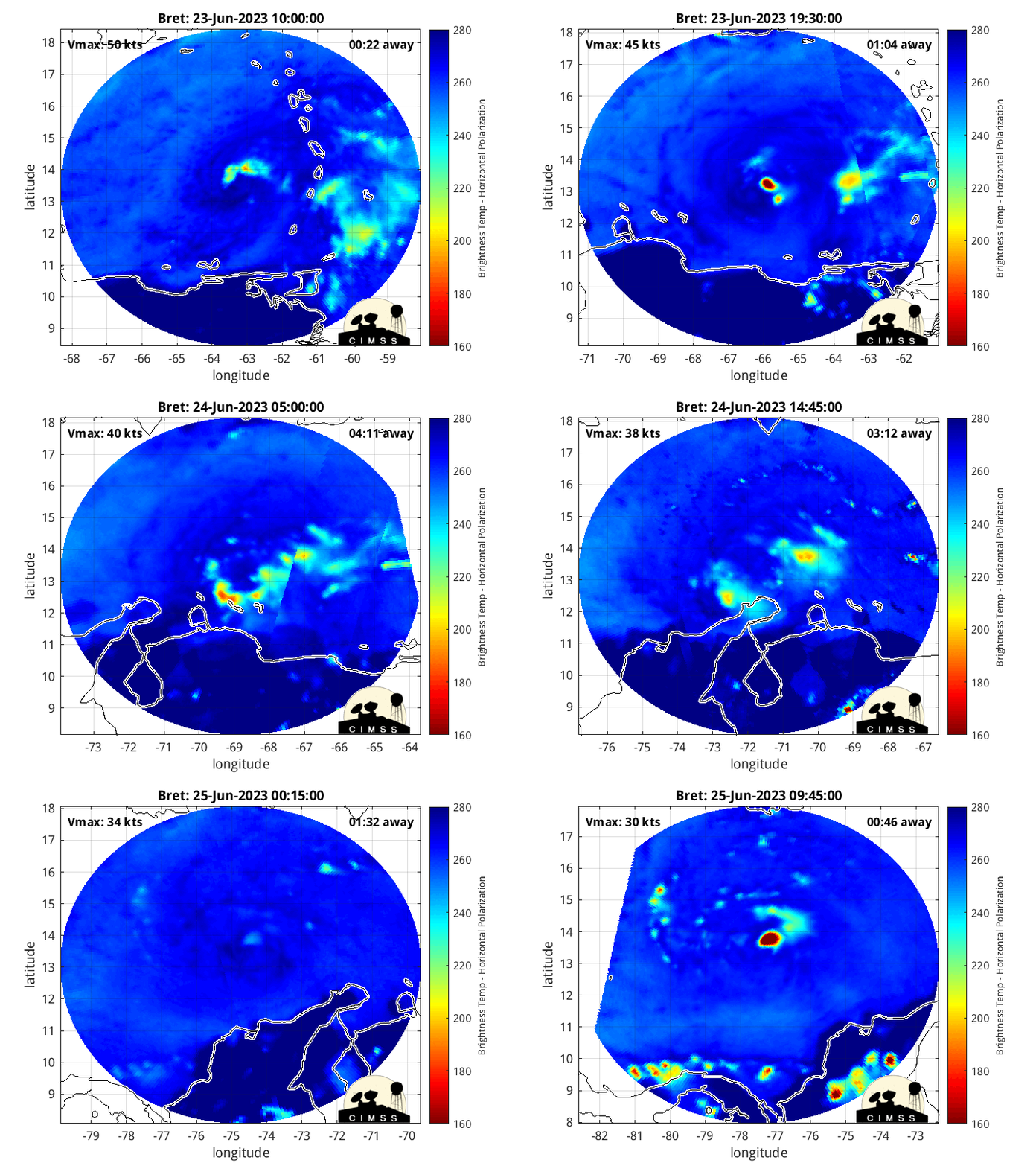
Tracking Bret – 2023 Atlantic Hurricane Season
NHC Important Links: NHC Discussion / Public Advisory / Forecast Advisory / Wind Probs / Graphics / Storm Archive
Storm Tracking Important Links:
Wind Analysis /
Coastal Inundation Info /
Tide Information /
Surge Map /
Surge Potential /
Coastal Risk Map /
Microwave Imagery /
Advanced Dvorak ADT /
GOES16 Satellite Storm Page /
FSU Track Probability /
NOAA Tracker /
Albany Tracker /
Navy NRL Page /
HFIP Products /
Tropical Atlantic Storm Page /
NCAR Guidance Page /
CyclonicWX Tracker /
CIMSS Tracker / Tropical Tidbits Storm Page /UWM Tracker / SFWMD Models
Other Floater Sites:TropicalTidbits - NRL Floaters - CyclonicWx - RAMMB Sat -
RAMMB Model Data -
RAMMB Wind Products
- Fri, 31 Oct 2025 14:42:19 +0000: Atlantic Post-Tropical Cyclone Melissa Advisory Number 41 - Atlantic Post-Tropical Cyclone Melissa Advisory Number 41
000
WTNT33 KNHC 311442
TCPAT3
BULLETIN
Post-Tropical Cyclone Melissa Advisory Number 41
NWS National Hurricane Center Miami FL AL132025
1100 AM AST Fri Oct 31 2025
...MELISSA BECOMES A POWERFUL POST-TROPICAL CYCLONE OVER THE
NORTHWEST ATLANTIC...
...THIS IS THE LAST NHC ADVISORY...
SUMMARY OF 1100 AM AST...1500 UTC...INFORMATION
-----------------------------------------------
LOCATION...39.0N 60.5W
ABOUT 520 MI...840 KM NNE OF BERMUDA
ABOUT 650 MI...1045 KM SW OF CAPE RACE NEWFOUNDLAND
MAXIMUM SUSTAINED WINDS...85 MPH...140 KM/H
PRESENT MOVEMENT...NE OR 40 DEGREES AT 48 MPH...78 KM/H
MINIMUM CENTRAL PRESSURE...973 MB...28.74 INCHES
WATCHES AND WARNINGS
--------------------
CHANGES WITH THIS ADVISORY:
None.
SUMMARY OF WATCHES AND WARNINGS IN EFFECT:
None.
A brief period of heavy rain and gusty winds is possible over the
southern Avalon Peninsula of Newfoundland tonight. For more
information on impacts in Canada, see the Canadian Hurricane Center
website at https://weather.gc.ca/hurricane/index_e.html
DISCUSSION AND OUTLOOK
----------------------
At 1100 AM AST (1500 UTC), the center of Post-Tropical Cyclone
Melissa was located near latitude 39.0 North, longitude 60.5 West.
The post-tropical cyclone is moving toward the northeast near 48 mph
(78 km/h). This general motion is expected to continue into
Saturday, followed by a gradual slowdown and turn toward the
east-northeast later this weekend. On the forecast track, the center
of Melissa is expected to pass to the southeast of the Avalon
Peninsula of Newfoundland as a post-tropical cyclone tonight.
Maximum sustained winds have decreased to near 85 mph (140 km/h)
with higher gusts. Gradual weakening is forecast during the next
few days.
Hurricane-force winds extend outward up to 105 miles (165 km) from
the center and tropical-storm-force winds extend outward up to 275
miles (445 km).
The estimated minimum central pressure is 973 mb (28.74 inches).
HAZARDS AFFECTING LAND
----------------------
Key messages for Melissa can be found in the Tropical Cyclone
Discussion under AWIPS header MIATCDAT3 and WMO header WTNT43 KNHC.
WIND: Gusty winds are possible over the southern Avalon Peninsula of
Newfoundland tonight.
RAINFALL: A brief period of heavy rain is possible over the southern
Avalon Peninsula of Newfoundland tonight.
SURF: Swells generated by Melissa will continue to affect portions
of the Bahamas, the Turks and Caicos Islands, Bermuda, the
Northeastern United States coast and portions of Atlantic Canada
during the next couple of days. These swells are likely to cause
life-threatening surf and rip current conditions. Please consult
products from your local weather office.
NEXT ADVISORY
-------------
This is the last public advisory issued by the National Hurricane
Center on this system. Additional information on this system can be
found in High Seas Forecasts issued by the National Weather Service,
under AWIPS header NFDHSFAT1, WMO header FZNT01 KWBC, and online at
ocean.weather.gov/shtml/NFDHSFAT1.php
$$
Forecaster Hagen
- Fri, 31 Oct 2025 14:41:18 +0000: Atlantic Post-Tropical Cyclone Melissa Forecast/Ad... - Atlantic Post-Tropical Cyclone Melissa Forecast/Advisory Number 41
000
WTNT23 KNHC 311441
TCMAT3
POST-TROPICAL CYCLONE MELISSA FORECAST/ADVISORY NUMBER 41
NWS NATIONAL HURRICANE CENTER MIAMI FL AL132025
1500 UTC FRI OCT 31 2025
POST-TROPICAL CYCLONE CENTER LOCATED NEAR 39.0N 60.5W AT 31/1500Z
POSITION ACCURATE WITHIN 30 NM
PRESENT MOVEMENT TOWARD THE NORTHEAST OR 40 DEGREES AT 42 KT
ESTIMATED MINIMUM CENTRAL PRESSURE 973 MB
MAX SUSTAINED WINDS 75 KT WITH GUSTS TO 90 KT.
64 KT....... 40NE 90SE 60SW 0NW.
50 KT....... 90NE 140SE 90SW 30NW.
34 KT.......180NE 240SE 200SW 90NW.
4 M SEAS....120NE 360SE 480SW 120NW.
WINDS AND SEAS VARY GREATLY IN EACH QUADRANT. RADII IN NAUTICAL
MILES ARE THE LARGEST RADII EXPECTED ANYWHERE IN THAT QUADRANT.
REPEAT...CENTER LOCATED NEAR 39.0N 60.5W AT 31/1500Z
AT 31/1200Z CENTER WAS LOCATED NEAR 37.5N 62.1W
FORECAST VALID 01/0000Z 43.5N 55.2W...POST-TROP/EXTRATROP
MAX WIND 70 KT...GUSTS 85 KT.
64 KT... 0NE 70SE 50SW 0NW.
50 KT... 90NE 140SE 100SW 0NW.
34 KT...200NE 300SE 290SW 130NW.
FORECAST VALID 01/1200Z 49.4N 48.0W...POST-TROP/EXTRATROP
MAX WIND 65 KT...GUSTS 80 KT.
64 KT... 0NE 60SE 0SW 0NW.
50 KT... 80NE 130SE 90SW 0NW.
34 KT...210NE 390SE 290SW 130NW.
FORECAST VALID 02/0000Z 53.2N 41.8W...POST-TROP/EXTRATROP
MAX WIND 60 KT...GUSTS 75 KT.
50 KT... 60NE 110SE 80SW 0NW.
34 KT...200NE 390SE 290SW 160NW.
FORECAST VALID 02/1200Z 55.0N 35.8W...POST-TROP/EXTRATROP
MAX WIND 55 KT...GUSTS 65 KT.
50 KT... 0NE 70SE 50SW 0NW.
34 KT...150NE 390SE 300SW 210NW.
FORECAST VALID 03/0000Z 56.2N 29.7W...POST-TROP/EXTRATROP
MAX WIND 50 KT...GUSTS 60 KT.
50 KT... 0NE 50SE 40SW 0NW.
34 KT... 90NE 300SE 240SW 160NW.
FORECAST VALID 03/1200Z 57.5N 24.4W...POST-TROP/EXTRATROP
MAX WIND 40 KT...GUSTS 50 KT.
34 KT... 0NE 210SE 210SW 0NW.
EXTENDED OUTLOOK. NOTE...ERRORS FOR TRACK HAVE AVERAGED NEAR 125 NM
ON DAY 4 AND 175 NM ON DAY 5...AND FOR INTENSITY NEAR 15 KT EACH DAY
OUTLOOK VALID 04/1200Z 60.5N 16.5W...POST-TROP/EXTRATROP
MAX WIND 35 KT...GUSTS 45 KT.
34 KT... 0NE 130SE 0SW 0NW.
OUTLOOK VALID 05/1200Z...DISSIPATED
REQUEST FOR 3 HOURLY SHIP REPORTS WITHIN 300 MILES OF 39.0N 60.5W
THIS IS THE LAST FORECAST/ADVISORY ISSUED BY THE NATIONAL HURRICANE
CENTER ON THIS SYSTEM. ADDITIONAL INFORMATION ON THIS SYSTEM CAN BE
FOUND IN HIGH SEAS FORECASTS ISSUED BY THE NATIONAL WEATHER
SERVICE...UNDER AWIPS HEADER NFDHSFAT1 AND WMO HEADER FZNT01 KWBC.
$$
FORECASTER HAGEN
- Fri, 31 Oct 2025 14:43:19 +0000: Atlantic Post-Tropical Cyclone Melissa Discussion Number 41 - Atlantic Post-Tropical Cyclone Melissa Discussion Number 41
000
WTNT43 KNHC 311443
TCDAT3
Post-Tropical Cyclone Melissa Discussion Number 41
NWS National Hurricane Center Miami FL AL132025
1100 AM AST Fri Oct 31 2025
Melissa no longer possesses organized convection, and is now merging
with a warm front extending eastward and a cold front extending
toward the southwest. Therefore, Melissa is now a post-tropical
cyclone. Melissa still has hurricane-force winds, especially in
the southeastern semicircle, as shown in Thursday evening ASCAT data
and also shown in the latest global model fields for the current
time of 15Z. The initial intensity is lowered slightly to 75 kt,
mainly based on forecast continuity. Large swells from Melissa are
spreading over much of the western Atlantic, resulting in hazardous
marine conditions in this region.
The post-tropical cyclone is racing northeastward, or 40 degrees at
42 kt. This motion should continue into Saturday within the flow
ahead of an upper-level trough. Track guidance is in excellent
agreement that the center of post-tropical Melissa will pass near,
but to the southeast of, the Avalon Peninsula of Newfoundland late
tonight, bringing the potential for some gusty winds and heavy rain.
Later this weekend, Melissa is forecast to turn east-northeastward
while interacting with a higher-latitude, upper-level low over the
North Atlantic. Very little change has been made to the NHC track
forecast, which lies very close to the average of the GFS and ECMWF
deterministic models (GFEX).
Global models indicate that Melissa will continue to be a large and
strong extratropical cyclone for the next couple of days as it
traverses the North Atlantic. Only gradual weakening is expected
through the weekend, with the system forecast to have
hurricane-force winds for another 24 h and still be a storm-force
cyclone in 60 hours. The NHC intensity forecast is at the high end
of the guidance suite through 60 hours. By early next week, global
models show the large system weakening further as it begins to join
up with a large and elongated area of low pressure over the far
northeastern Atlantic, and the system should be absorbed and
dissipated just beyond the 96-hour point.
Key Messages:
1. Post-storm safety: Follow advice of local officials and avoid
areas of downed power lines and flooding. Ensure generators are
properly ventilated and placed outside at least 20 feet away from
dwellings and garages to avoid carbon monoxide poisoning. During
clean up, be careful when using chainsaws and power tools. Drink
plenty of water to avoid heat exhaustion.
FORECAST POSITIONS AND MAX WINDS
INIT 31/1500Z 39.0N 60.5W 75 KT 85 MPH...POST-TROP/EXTRATROP
12H 01/0000Z 43.5N 55.2W 70 KT 80 MPH...POST-TROP/EXTRATROP
24H 01/1200Z 49.4N 48.0W 65 KT 75 MPH...POST-TROP/EXTRATROP
36H 02/0000Z 53.2N 41.8W 60 KT 70 MPH...POST-TROP/EXTRATROP
48H 02/1200Z 55.0N 35.8W 55 KT 65 MPH...POST-TROP/EXTRATROP
60H 03/0000Z 56.2N 29.7W 50 KT 60 MPH...POST-TROP/EXTRATROP
72H 03/1200Z 57.5N 24.4W 40 KT 45 MPH...POST-TROP/EXTRATROP
96H 04/1200Z 60.5N 16.5W 35 KT 40 MPH...POST-TROP/EXTRATROP
120H 05/1200Z...DISSIPATED
$$
Forecaster Hagen

 DONATE