NHC Important Links: NHC Discussion / Public Advisory / Forecast Advisory / Wind Probs / NWS Local Products / US Watch/Warning / Graphics / Storm Archive
Important LOCAL Links: NWS Key West / NWS Miami / NWS Tampa Bay / NWS Melbourne / NWS Winds/Gusts/Waves Map / Current Power Outages / SPC Watches and Warnings
Storm Tracking Important Links: Wind Analysis / Coastal Inundation Info / Tide Information / Surge Map / Surge Potential / Coastal Risk Map / Microwave Imagery / Advanced Dvorak ADT / GOES16 Satellite Storm Page / FSU Track Probability / NOAA Tracker / Albany Tracker / Navy NRL Page / HFIP Products / Tropical Atlantic Storm Page / NCAR Guidance Page / CyclonicWX Tracker / CIMSS Tracker / Tropical Tidbits Storm Page /UWM Tracker / SFWMD Models
Peak Storm Surge Forecast

Potential Storm Surge Flooding Map (Inundation)
Additional Potential Storm Surge Map
Flash Flood Risk

Rainfall Forecasts


5 Day WPC Rainfall Forecast

24 hour - 7 Day

Potential Storm Surge Flooding Map (Inundation)
Additional Potential Storm Surge Map
Flash Flood Risk

Rainfall Forecasts


5 Day WPC Rainfall Forecast

24 hour - 7 Day
WeatherNerds.org Floaters
Other Floater Sites:
TropicalTidbits - NRL Floaters - CyclonicWx - RAMMB Sat - RAMMB Model Data - RAMMB Wind Products

|

|

|

|
TropicalTidbits - NRL Floaters - CyclonicWx - RAMMB Sat - RAMMB Model Data - RAMMB Wind Products
- Tue, 22 Oct 2024 11:54:57 +0000: Atlantic Tropical Storm Oscar Intermediate Advisory Number 13A - Atlantic Tropical Storm Oscar Intermediate Advisory Number 13A
000
WTNT31 KNHC 221154
TCPAT1
BULLETIN
Tropical Storm Oscar Intermediate Advisory Number 13A
NWS National Hurricane Center Miami FL AL162024
800 AM EDT Tue Oct 22 2024
...OSCAR CONTINUES MOVING THROUGH THE CENTRAL AND SOUTHEASTERN
BAHAMAS...
SUMMARY OF 800 AM EDT...1200 UTC...INFORMATION
----------------------------------------------
LOCATION...22.8N 74.7W
ABOUT 45 MI...75 KM SE OF LONG ISLAND
MAXIMUM SUSTAINED WINDS...40 MPH...65 KM/H
PRESENT MOVEMENT...NE OR 35 DEGREES AT 12 MPH...19 KM/H
MINIMUM CENTRAL PRESSURE...1006 MB...29.71 INCHES
WATCHES AND WARNINGS
--------------------
CHANGES WITH THIS ADVISORY:
None.
SUMMARY OF WATCHES AND WARNINGS IN EFFECT:
A Tropical Storm Warning is in effect for...
* Central Bahamas
* Southeastern Bahamas
A Tropical Storm Warning means that tropical storm conditions are
expected somewhere within the warning area.
For storm information specific to your area, please monitor
products issued by your national meteorological service.
DISCUSSION AND OUTLOOK
----------------------
At 800 AM EDT (1200 UTC), the center of Tropical Storm Oscar was
located near latitude 22.8 North, longitude 74.7 West. Oscar is
moving toward the northeast near 12 mph (19 km/h). A faster
northeastward motion is expected later today and on Wednesday. On
the forecast track, the center of Oscar is expected to move near the
southeastern and central Bahamas today, then move away from the
Bahamas tonight and Wednesday.
Maximum sustained winds are near 40 mph (65 km/h) with higher gusts.
Little change in strength is forecast during the day today. Oscar is
expected to become a post-tropical low by tonight or early
Wednesday, and then be absorbed by another low pressure area by
Thursday.
Tropical-storm-force winds extend outward up to 105 miles (165 km)
east and northeast of the center.
The estimated minimum central pressure is 1006 mb (29.71 inches).
HAZARDS AFFECTING LAND
----------------------
Key messages for Oscar can be found in the Tropical Cyclone
Discussion under AWIPS header MIATCDAT1 and WMO header WTNT41 KNHC
and on the web at hurricanes.gov/text/MIATCDAT1.shtml
WIND: Tropical storm conditions are expected in the warning area in
parts of the central and southeastern Bahamas today.
RAINFALL: Across the southeastern Bahamas and the Turks and Caicos
Islands, rainfall amounts of 3 to 5 inches, with isolated amounts
around 8 inches, are expected through today. This rainfall could
cause localized flash flooding.
For a complete depiction of forecast rainfall associated with Oscar,
please see the National Weather Service Storm Total Rainfall
Graphic, available at hurricanes.gov/graphics_at1.shtml?rainqpf.
NEXT ADVISORY
-------------
Next complete advisory at 1100 AM EDT.
$$
Forecaster Pasch
- Tue, 22 Oct 2024 08:31:52 +0000: Atlantic Tropical Storm OSCAR Forecast/Advisory Nu... - Atlantic Tropical Storm OSCAR Forecast/Advisory Number 13 NWS NATIONAL Hurricane CENTER MIAMI FL AL162024 0900 UTC TUE OCT 22 2024 TROPICAL STORM CENTER LOCATED NEAR 22.7N 74.8W AT 22/0900Z POSITION ACCURATE WITHIN 30 NM PRESENT MOVEMENT TOWARD THE NORTH-NORTHEAST OR 30 DEGREES AT 10 KT ESTIMATED MINIMUM CENTRAL PRESSURE 1006 MB MAX SUSTAINED WINDS 35 KT WITH GUSTS TO 45 KT. 34 KT....... 90NE 90SE 0SW 0NW. 12 FT SEAS.. 0NE 60SE 0SW 0NW. WINDS AND SEAS VARY GREATLY IN EACH QUADRANT. RADII IN NAUTICAL MILES ARE THE LARGEST RADII EXPECTED ANYWHERE IN THAT QUADRANT. REPEAT...CENTER LOCATED NEAR 22.7N 74.8W AT 22/0900Z AT 22/0600Z CENTER WAS LOCATED NEAR 22.3N 75.1W FORECAST VALID 22/1800Z 23.8N 73.8W MAX WIND 35 KT...GUSTS 45 KT. 34 KT... 80NE 80SE 0SW 0NW. FORECAST VALID 23/0600Z 25.7N 71.7W...Post-TROPICAL MAX WIND 35 KT...GUSTS 45 KT. 34 KT... 40NE 80SE 0SW 0NW. FORECAST VALID 23/1800Z 28.5N 69.5W...POST-TROP/EXTRATROP MAX WIND 35 KT...GUSTS 45 KT. 34 KT... 40NE 80SE 0SW 0NW. FORECAST VALID 24/0600Z...DISSIPATED REQUEST FOR 3 HOURLY SHIP REPORTS WITHIN 300 MILES OF 22.7N 74.8W Intermediate PUBLIC Advisory...WTNT31 KNHC/MIATCPAT1...AT 22/1200Z NEXT ADVISORY AT 22/1500Z $$ FORECASTER BEVEN
000
WTNT21 KNHC 220831
TCMAT1
TROPICAL STORM OSCAR FORECAST/ADVISORY NUMBER 13
NWS NATIONAL HURRICANE CENTER MIAMI FL AL162024
0900 UTC TUE OCT 22 2024
TROPICAL STORM CENTER LOCATED NEAR 22.7N 74.8W AT 22/0900Z
POSITION ACCURATE WITHIN 30 NM
PRESENT MOVEMENT TOWARD THE NORTH-NORTHEAST OR 30 DEGREES AT 10 KT
ESTIMATED MINIMUM CENTRAL PRESSURE 1006 MB
MAX SUSTAINED WINDS 35 KT WITH GUSTS TO 45 KT.
34 KT....... 90NE 90SE 0SW 0NW.
12 FT SEAS.. 0NE 60SE 0SW 0NW.
WINDS AND SEAS VARY GREATLY IN EACH QUADRANT. RADII IN NAUTICAL
MILES ARE THE LARGEST RADII EXPECTED ANYWHERE IN THAT QUADRANT.
REPEAT...CENTER LOCATED NEAR 22.7N 74.8W AT 22/0900Z
AT 22/0600Z CENTER WAS LOCATED NEAR 22.3N 75.1W
FORECAST VALID 22/1800Z 23.8N 73.8W
MAX WIND 35 KT...GUSTS 45 KT.
34 KT... 80NE 80SE 0SW 0NW.
FORECAST VALID 23/0600Z 25.7N 71.7W...POST-TROPICAL
MAX WIND 35 KT...GUSTS 45 KT.
34 KT... 40NE 80SE 0SW 0NW.
FORECAST VALID 23/1800Z 28.5N 69.5W...POST-TROP/EXTRATROP
MAX WIND 35 KT...GUSTS 45 KT.
34 KT... 40NE 80SE 0SW 0NW.
FORECAST VALID 24/0600Z...DISSIPATED
REQUEST FOR 3 HOURLY SHIP REPORTS WITHIN 300 MILES OF 22.7N 74.8W
INTERMEDIATE PUBLIC ADVISORY...WTNT31 KNHC/MIATCPAT1...AT 22/1200Z
NEXT ADVISORY AT 22/1500Z
$$
FORECASTER BEVEN
- Tue, 22 Oct 2024 08:33:21 +0000: Atlantic Tropical Storm Oscar Discussion Number 13 - Atlantic Tropical Storm Oscar Discussion Number 13
588
WTNT41 KNHC 220833
TCDAT1
Tropical Storm Oscar Discussion Number 13
NWS National Hurricane Center Miami FL AL162024
500 AM EDT Tue Oct 22 2024
Oscar is at best barely a tropical storm at this time. While
convection associated with the system has increased since the last
advisory, most of it is occurring in clusters well away from the
center in the eastern semicircle, and there is only minimal
convection near the center. Also, while 850 mb flight-level winds
were as high as 45-50 kt during an earlier Air Force Reserve
Hurricane Hunter mission, dropsonde and SFMR data suggests those
winds were having trouble mixing down to the surface. The system
will be maintained as a 35-kt tropical storm pending the next recon
flight and whether convection will increase further during the
upcoming diurnal maximum.
The global models are in good agreement that a developing mid- to
upper-level trough over the southwestern Atlantic will cause
baroclinic cyclogenesis near or north of Oscar during the next
24-48 h. The UKMET shows Oscar become the main focus for the
development and becoming a large extratropical low, while the GFS
develops a second low to the north of Oscar with Oscar becoming
absorbed into the new system. The ECMWF and Canadian models
forecast a blend of these scenarios, with the baroclinic low forming
close to Oscar. Given Oscar's organization and current trends in
satellite imagery, the intensity forecast leans towards the GFS
solution, with Oscar becoming a post-tropical low in less than 24 h
and then being absorbed by the new low in 36-48 h.
The initial motion is now 030/10 kt. Interaction with the above
mentioned trough should steer Oscar generally northeastward with an
increase in forward speed until it is absorbed by the new
baroclinic low. The new forecast track is similar to the previous
track.
Key Messages:
1. Through Tuesday, localized flash flooding will be possible across
the southeastern Bahamas as well as the Turks and Caicos Islands.
With rainfall easing across Cuba, flooding from rainfall which has
already occurred could remain a concern for the next several days.
2. Tropical storm conditions are expected in portions of the
southeastern and central Bahamas today.
FORECAST POSITIONS AND MAX WINDS
INIT 22/0900Z 22.7N 74.8W 35 KT 40 MPH
12H 22/1800Z 23.8N 73.8W 35 KT 40 MPH
24H 23/0600Z 25.7N 71.7W 35 KT 40 MPH...POST-TROPICAL
36H 23/1800Z 28.5N 69.5W 35 KT 40 MPH...POST-TROP/EXTRATROP
48H 24/0600Z...DISSIPATED
$$
Forecaster Beven

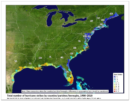
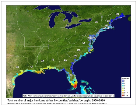
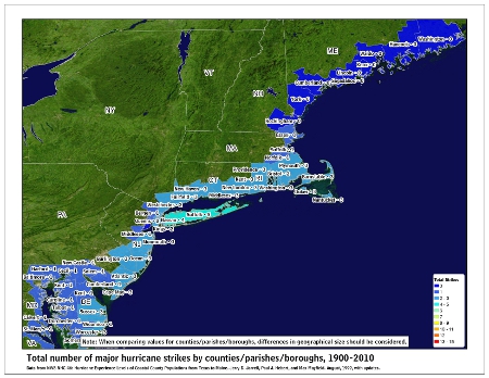
![[Map of 1950-2017 CONUS Hurricane Strikes]](http://www.nhc.noaa.gov/climo/images/conus_strikes_sm.jpg)
