234 Visitors Tracking The Tropics!
SHOW ME SOME LOVE AND SUPPORT
Website: TrackTheTropics.com/DONATE
Venmo: @TrackTheTropicsLouisiana
Cash App: Cash.App/$TrackTheTropics
Subscribe: FB.com/TrackTheTropics
Website: TrackTheTropics.com/DONATE
Venmo: @TrackTheTropicsLouisiana
Cash App: Cash.App/$TrackTheTropics
Subscribe: FB.com/TrackTheTropics

Track The Tropics is the #1 source to track the tropics 24/7! Since 2013 the main goal of the site is to bring all of the important links and graphics to ONE PLACE so you can keep up to date on any threats to land during the Atlantic Hurricane Season! Hurricane Season 2026 in the Atlantic starts on June 1st and ends on November 30th. Do you love Spaghetti Models? Well you've come to the right place!! Remember when you're preparing for a storm: Run from the water; hide from the wind!
Tropical Atlantic Weather Resources
- NOAA National Hurricane Center
- International Meteorology Database
- FSU Tropical Cyclone Track Probabilities
- Brian McNoldy Atlantic Headquarters
- Brian McNoldy Tropical Satellite Sectors
- Brian McNoldy Infrared Hovmoller
- Brian McNoldy Past TC Radar Loops
- Weather Nerds TC Guidance
- Twister Data Model Guidance
- NOAA Tropical Cyclone Tracks
- Albany GFS/ EURO Models/ Ensembles
- Albany Tropical Cyclone Guidance
- Albany Tropical Atlantic Model Maps
- Pivotal Weather Model Guidance
- Weather Online Model Guidance
- UKMet Model Guidance/ Analysis/ Sat
- ECMWF (EURO) Model Guidance
- FSU Tropical Model Outputs
- FSU Tropical Cyclone Genesis
- Penn State Tropical E-Wall
- NOAA HFIP Ruc Models
- Navy NRL TC Page
- College of DuPage Model Guidance
- WXCharts Model Guidance
- NOAA NHC Analysis Tools
- NOAA NHC ATCF Directory
- NOAA NCEP/EMC Cyclogenesis Tracking
- NOAA NCEP/EMC HWRF Model
- NOAA HFIP Model Products
- University of Miami Ocean Heat
- COLA Max Potential Hurricane Intensity
- Colorado State RAMMB TC Tracking
- Colorado State RAMMB Floaters
- Colorado State RAMMB GOES-16 Viewer
- NOAA NESDIS GOES Satellite
- ASCAT Ocean Surface Winds METOP-A
- ASCAT Ocean Surface Winds METOP-B
- Michael Ventrice Waves / MJO Maps
- TropicalAtlantic.com Analysis / Recon
- NCAR/RAL Tropical Cyclone Guidance
- CyclonicWX Tropical Resources
Historic Louisiana Storms By Month
January
June
July
August
September
October
2016 Hurricane Season Outlook from Louisiana Hurricane Center
Today June 1st marks the "OFFICIAL" start of the 2016 Hurricane Season and we already have had named 2 storms! Hurricane Alex formed in January and Tropical Storm Bonnie just made landfall recently in South Carolina.
Louisiana Hurricane Center's Thoughts on this season
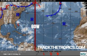
With all of the data and forecasts I have gone over the past few months my thinking is that we will get a slightly ABOVE average season. In my opinion environmental conditions this year out in the Atlantic EAST of 60W longitude will NOT be favorable for any kind of development. I think most of our storms this year will develop closer to home WEST of 60W from tropical waves entering the Caribbean and homegrown systems developing in the Gulf of Mexico and also right off the East coast. In my image to the left I have highlighted the 60W marker to give you a good visual on where I think development will occur. Below you will find all of the season forecasts by the experts. Regardless of what kind of season we have and regardless of who is right or wrong on their forecasts remember this: IT ONLY TAKES ONE SO ALWAYS BE PREPARED!
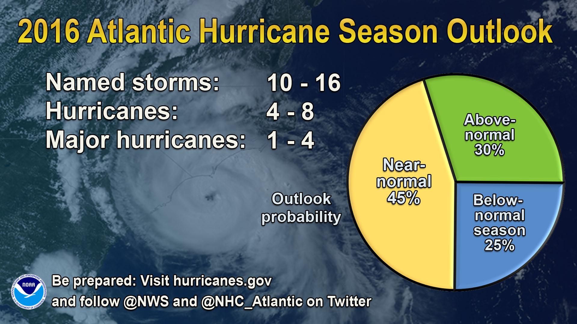
NOAA’s Climate Prediction Center: says the 2016 Atlantic hurricane season, which runs from June 1 through November 30, will most likely be near-normal, but forecast uncertainty in the climate signals that influence the formation of Atlantic storms make predicting this season particularly difficult. NOAA predicts a 70 percent likelihood of 10 to 16 named storms (winds of 39 mph or higher), of which 4 to 8 could become hurricanes (winds of 74 mph or higher), including 1 to 4 major hurricanes (Category 3, 4 or 5; winds of 111 mph or higher). While a near-normal season is most likely with a 45 percent chance, there is also a 30 percent chance of an above-normal season and a 25 percent chance of a below-normal season. CLICK HERE for the entire NOAA outlook.
Colorado State University (Philip J. Klotzbach and William M. Gray): We anticipate that the 2016 Atlantic basin hurricane season will have approximately average activity. The current weakening El Niño is likely to transition to either neutral or La Niña conditions by the peak of the Atlantic hurricane season. While the tropical Atlantic is relatively warm, the far North Atlantic is quite cold, potentially indicative of a negative phase of the Atlantic Multi-Decadal Oscillation. We anticipate a near-average probability for major hurricanes making landfall along the United States coastline and in the Caribbean. As is the case with all hurricane seasons, coastal residents are reminded that it only takes one hurricane making landfall to make it an active season for them. They should prepare the same for every season, regardless of how much activity is predicted. We estimate that 2016 will have 6 hurricanes (median is 6.5), 13 named storms (median is 12.0), 50 named storm days (median is 60.1), 20 hurricane days (median is 21.3), 2 major (Category 3-4-5) hurricane (median is 2.0) and 4 major hurricane days (median is 3.9). The probability of U.S. major hurricane landfall is estimated to be about 90 percent of the long-period average. We expect Atlantic basin Accumulated Cyclone Energy (ACE) and Net Tropical Cyclone (NTC) activity in 2016 to be approximately 95 percent of their long-term averages. CLICK HERE for the entire CSU forecast.
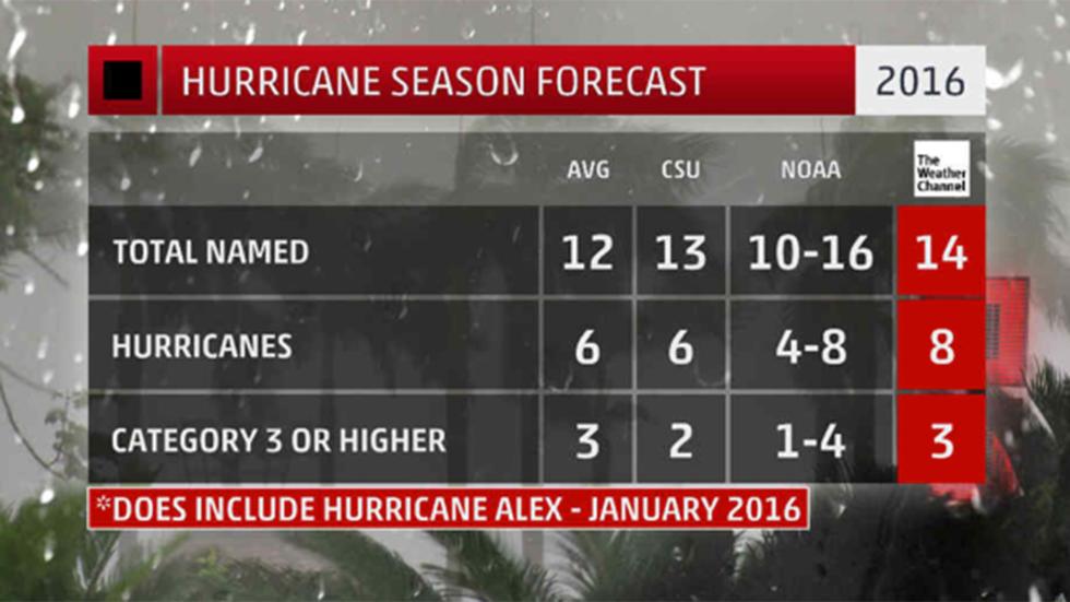
The Weather Channel: The 2016 Atlantic hurricane season is expected to be the most active since 2012. A total of 14 named storms, eight hurricanes and three major hurricanes are forecast during the coming season. This is greater than the 30-year historical average of 12 named storms, six hurricanes and three major hurricanes for the Atlantic basin. A major hurricane is one that is Category 3 or stronger on the Saffir-Simpson Hurricane Wind Scale. CLICK HERE for the entire TWC forecast.
Global Weather Oscillations (GWO): says the 2016 and 2017 Atlantic hurricane seasons will be the strongest in over 4 years, and have the most United States hurricane landfalls since 11 were experienced during the destructive seasons of 2004 and 2005. CEO David Dilley of GWO says the combination of the El Niño ending before the 2016 hurricane season, and the high number of named storms (12) connected to the 2015 season - signals that a “Climate Pulse Hurricane Enhancement Cycle” is now in place, and this will provide very favorable atmospheric conditions for hurricane development and landfalls during the next couple of years. GWO is calling for a very active season, The 2016 season will have 17 named storms, 9 hurricanes, and 4 major hurricanes. Three of the GWO United States prediction zones are at high risk for hurricane conditions in 2016. One of the zones has a high risk for a major impact hurricane. CLICK HERE for the entire GWO forecast.
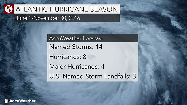
Accuweather: says the potential movement of a 'cold blob' of water in the North Atlantic Ocean may be the wild card in the 2016 Atlantic hurricane season. The cold blob refers to a large, anomalous area of colder-than-normal sea-surface temperatures, located east of Newfoundland and south of Greenland. "This area of colder water started to show up a few years ago and has become larger and more persistent during the past couple of years," AccuWeather Atlantic Hurricane Expert Dan Kottlowski said. Accuweather says we will have an above average season with 14 named storms, 8 of those storms will become Hurricanes and 4 of the Hurricanes will become major. CLICK HERE for the entire Accuweather forecast.