SUPPORT TRACK THE TROPICS
Over the last decade plus if you appreciate the information and tracking I provide during the season along with this website which donations help keep it running please consider a one time... recurring or yearly donation if you are able to help me out...
Venmo: @TrackTheTropicsLouisiana
Website: TrackTheTropics.com/DONATE
Venmo: @TrackTheTropicsLouisiana
Website: TrackTheTropics.com/DONATE
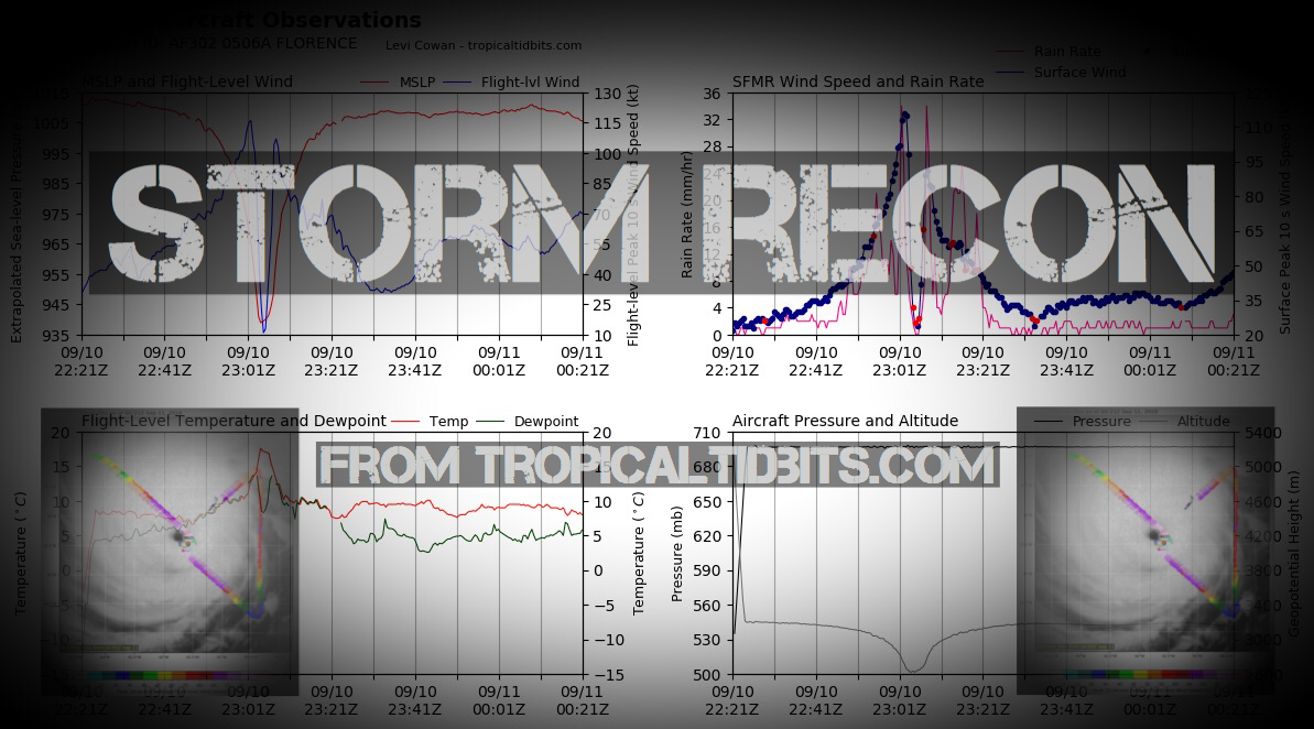
Storm Recon
CONUS Hurricane Strikes
![[Map of 1950-2017 CONUS Hurricane Strikes]](http://www.nhc.noaa.gov/climo/images/conus_strikes.jpg)
Total Hurricane Strikes 1900-2010

Total MAJOR Hurricane Strikes 1900-2010

Western Gulf Hurricane Strikes

Western Gulf MAJOR Hurricane Strikes

Eastern Gulf Hurricane Strikes

Eastern Gulf MAJOR Hurricane Strikes

SE Coast Hurricane Strikes

SE Coast MAJOR Hurricane Strikes

NE Coast Hurricane Strikes

NE Coast MAJOR Hurricane Strikes

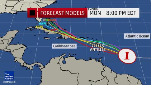 An Invest (short for Investigation), also called an area of interest, is a designated area of disturbed weather in the tropics investigated by the National Hurricane Center (NHC). Once the National Hurricane Center declares an Investigation Area, spaghetti models are run on the system to project the future track possibilities, like the ones shown in the image, as well as the potential future intensity. That said, the "Invest" assignment does not correspond to how likely a system may develop into a tropical depression or storm!
The term Invest is followed by the numbers 90 through 99 and either the letter "L" for the Atlantic basin systems or "E" for the eastern Pacific systems. These full labels in the Atlantic would be displayed as Invest 90L, Invest 91L, etc. In the eastern Pacific, you would see Invest 90E, Invest 91E, etc. Once the end of the list is reached with either Invest 99L in the Atlantic or Invest 99E in the eastern Pacific, it starts back over again with Invest 90L or Invest 90E. The process can be repeated for as many times as needed. Many times in discussions these designations will be shortened to 90L, 91L, and so forth.
This naming system gives forecasters a way of keeping track of weather systems on which they want to begin gathering more detailed information. Also when we have multiple tropical disturbances out there this system also makes it easier for meteorologists to communicate what invest the are talking about!
I hope this information helps you understand now when people during Hurricane Season mention the word INVEST! As always Track The Tropics is the #1 source to track the tropics 24/7 and keep up to date on any threats to land during the Atlantic Hurricane Season! Be sure to visit my home page and the tons of other information I have on the site.
An Invest (short for Investigation), also called an area of interest, is a designated area of disturbed weather in the tropics investigated by the National Hurricane Center (NHC). Once the National Hurricane Center declares an Investigation Area, spaghetti models are run on the system to project the future track possibilities, like the ones shown in the image, as well as the potential future intensity. That said, the "Invest" assignment does not correspond to how likely a system may develop into a tropical depression or storm!
The term Invest is followed by the numbers 90 through 99 and either the letter "L" for the Atlantic basin systems or "E" for the eastern Pacific systems. These full labels in the Atlantic would be displayed as Invest 90L, Invest 91L, etc. In the eastern Pacific, you would see Invest 90E, Invest 91E, etc. Once the end of the list is reached with either Invest 99L in the Atlantic or Invest 99E in the eastern Pacific, it starts back over again with Invest 90L or Invest 90E. The process can be repeated for as many times as needed. Many times in discussions these designations will be shortened to 90L, 91L, and so forth.
This naming system gives forecasters a way of keeping track of weather systems on which they want to begin gathering more detailed information. Also when we have multiple tropical disturbances out there this system also makes it easier for meteorologists to communicate what invest the are talking about!
I hope this information helps you understand now when people during Hurricane Season mention the word INVEST! As always Track The Tropics is the #1 source to track the tropics 24/7 and keep up to date on any threats to land during the Atlantic Hurricane Season! Be sure to visit my home page and the tons of other information I have on the site.