0 Active Threats To Track
SUPPORT TRACK THE TROPICS
Over the last decade plus if you appreciate the information and tracking I provide during the season along with this website which donations help keep it running please consider a one time... recurring or yearly donation if you are able to help me out...
Venmo: @TrackTheTropicsLouisiana
Website: TrackTheTropics.com/DONATE
Venmo: @TrackTheTropicsLouisiana
Website: TrackTheTropics.com/DONATE
Track The Tropics is the #1 source to track the tropics 24/7! Since 2013 the main goal of the site is to bring all of the important links and graphics to ONE PLACE so you can keep up to date on any threats to land during the Atlantic Hurricane Season! Hurricane Season 2025 in the Atlantic starts on June 1st and ends on November 30th. Do you love Spaghetti Models? Well you've come to the right place!! Remember when you're preparing for a storm: Run from the water; hide from the wind!
Tropical Atlantic Weather Resources
- NOAA National Hurricane Center
- International Meteorology Database
- FSU Tropical Cyclone Track Probabilities
- Brian McNoldy Atlantic Headquarters
- Brian McNoldy Tropical Satellite Sectors
- Brian McNoldy Infrared Hovmoller
- Brian McNoldy Past TC Radar Loops
- Weather Nerds TC Guidance
- Twister Data Model Guidance
- NOAA Tropical Cyclone Tracks
- Albany GFS/ EURO Models/ Ensembles
- Albany Tropical Cyclone Guidance
- Albany Tropical Atlantic Model Maps
- Pivotal Weather Model Guidance
- Weather Online Model Guidance
- UKMet Model Guidance/ Analysis/ Sat
- ECMWF (EURO) Model Guidance
- FSU Tropical Model Outputs
- FSU Tropical Cyclone Genesis
- Penn State Tropical E-Wall
- NOAA HFIP Ruc Models
- Navy NRL TC Page
- College of DuPage Model Guidance
- WXCharts Model Guidance
- NOAA NHC Analysis Tools
- NOAA NHC ATCF Directory
- NOAA NCEP/EMC Cyclogenesis Tracking
- NOAA NCEP/EMC HWRF Model
- NOAA HFIP Model Products
- University of Miami Ocean Heat
- COLA Max Potential Hurricane Intensity
- Colorado State RAMMB TC Tracking
- Colorado State RAMMB Floaters
- Colorado State RAMMB GOES-16 Viewer
- NOAA NESDIS GOES Satellite
- ASCAT Ocean Surface Winds METOP-A
- ASCAT Ocean Surface Winds METOP-B
- Michael Ventrice Waves / MJO Maps
- TropicalAtlantic.com Analysis / Recon
- NCAR/RAL Tropical Cyclone Guidance
- CyclonicWX Tropical Resources
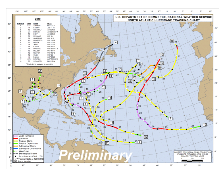
2019 Hurricane Season Storms
The 2019 Hurricane Season as far as numbers go was an active above average
one. It was marked by tropical activity that churned busily from mid-August through October. The
season produced 18 named storms, including six hurricanes of which three were “major”
(Category 3, 4 or 5). NOAA’s outlook called for 10-17 named storms, 5-9 hurricanes and 2-4 major
hurricanes, and accurately predicted the overall activity of the season. You can find the other Season predictions
HERE.


Check out a 60 second satellite loop video of the Season...
Subtropical Storm
ANDREA
Duration May 20 – May 21 2019
Peak intensity 40 mph (65 km/h) (1-min)
1006 mbar (hPa) WIKI
Peak intensity 40 mph (65 km/h) (1-min)
1006 mbar (hPa) WIKI
Hurricane
BARRY
Duration July 11 – July 16 2019
Peak intensity 75 mph (120 km/h) (1-min)
993 mbar (hPa) WIKI
Peak intensity 75 mph (120 km/h) (1-min)
993 mbar (hPa) WIKI
Tropical Depression
THREE
Duration July 22 – July 23 2019
Peak intensity 35 mph (55 km/h) (1-min)
1013 mbar (hPa) WIKI
Peak intensity 35 mph (55 km/h) (1-min)
1013 mbar (hPa) WIKI
Tropical Storm CHANTAL
Duration August
20 – August 23 2019
Peak intensity 40 mph (65 km/h) (1-min)
1007 mbar (hPa) WIKI
Peak intensity 40 mph (65 km/h) (1-min)
1007 mbar (hPa) WIKI
MAJOR Hurricane DORIAN (Category
5)
Duration August 24 – September 10 2019
Peak intensity 185 mph (295 km/h) (1-min)
910 mbar (hPa) WIKI
Peak intensity 185 mph (295 km/h) (1-min)
910 mbar (hPa) WIKI
Tropical Storm
ERIN
Duration August 26 – August 29 2019
Peak intensity 40 mph (65 km/h) (1-min)
1002 mbar (hPa) WIKI
Peak intensity 40 mph (65 km/h) (1-min)
1002 mbar (hPa) WIKI
Tropical Storm
FERNAND
Duration September 3 – September 5 2019
Peak intensity 50 mph (85 km/h) (1-min)
1000 mbar (hPa) WIKI
Peak intensity 50 mph (85 km/h) (1-min)
1000 mbar (hPa) WIKI
Tropical Storm
GABRIELLE
Duration September 3 – September 10 2019
Peak intensity 65 mph (100 km/h) (1-min)
1005 mbar (hPa) WIKI
Peak intensity 65 mph (100 km/h) (1-min)
1005 mbar (hPa) WIKI
MAJOR Hurricane HUMBERTO (Category
3)
Duration September 13 – September 20 2019
Peak intensity 125 mph (205 km/h) (1-min)
950 mbar (hPa) WIKI
Peak intensity 125 mph (205 km/h) (1-min)
950 mbar (hPa) WIKI
Tropical Storm
IMELDA
Duration September 17 – September 21 2019
Peak intensity 45 mph (75 km/h) (1-min)
1003 mbar (hPa) WIKI
Peak intensity 45 mph (75 km/h) (1-min)
1003 mbar (hPa) WIKI
Hurricane
JERRY
Duration September 17 – September 24 2019
Peak intensity 60 mph (95 km/h) (1-min)
976 mbar (hPa) WIKI
Peak intensity 60 mph (95 km/h) (1-min)
976 mbar (hPa) WIKI
Tropical Storm
KAREN
Duration September 22 – September 27 2019
Peak intensity 45 mph (75 km/h) (1-min)
1003 mbar (hPa) WIKI
Peak intensity 45 mph (75 km/h) (1-min)
1003 mbar (hPa) WIKI
MAJOR Hurricane LORENZO (Category
5)
Duration September 23 – October 4 2019
Peak intensity 160 mph (260 km/h) (1-min)
925 mbar (hPa) WIKI
Peak intensity 160 mph (260 km/h) (1-min)
925 mbar (hPa) WIKI
Tropical Storm
MELISSA
Duration October 11 – October 14 2019
Peak intensity 65 mph (100 km/h) (1-min)
994 mbar (hPa) WIKI
Peak intensity 65 mph (100 km/h) (1-min)
994 mbar (hPa) WIKI
Tropical Depression
FIFTEEN
Duration October 14 – October 16 2019
Peak intensity 35 mph (55 km/h) (1-min)
1006 mbar (hPa) WIKI
Peak intensity 35 mph (55 km/h) (1-min)
1006 mbar (hPa) WIKI
Tropical Storm
NESTOR
Duration October 18 – October 21 2019
Peak intensity 60 mph (95 km/h) (1-min)
996 mbar (hPa) WIKI
Peak intensity 60 mph (95 km/h) (1-min)
996 mbar (hPa) WIKI
Tropical Storm
OLGA
Duration October 25 – October 28 2019
Peak intensity 45 mph (75 km/h) (1-min)
998 mbar (hPa) WIKI
Peak intensity 45 mph (75 km/h) (1-min)
998 mbar (hPa) WIKI
Hurricane
PABLO
Duration October 25 – October 28 2019
Peak intensity 80 mph (130 km/h) (1-min)
997 mbar (hPa) WIKI
Peak intensity 80 mph (130 km/h) (1-min)
997 mbar (hPa) WIKI
Subtropical Storm
REBEKAH
Duration October 30 – November 1 2019
Peak intensity 50 mph (85 km/h) (1-min)
982 mbar (hPa) WIKI
Peak intensity 50 mph (85 km/h) (1-min)
982 mbar (hPa) WIKI
Tropical Storm
SEBASTIEN
Duration November 19 – November 24 2019
Peak intensity 70 mph (110 km/h) (1-min)
991 mbar (hPa) WIKI
Peak intensity 70 mph (110 km/h) (1-min)
991 mbar (hPa) WIKI


 DONATE