145 Visitors Tracking The Tropics!
PLEASE SUPPORT TRACK THE TROPICS

Track The Tropics is the #1 source to track the tropics 24/7! Since 2013 the main goal of the site is to bring all of the important links and graphics to ONE PLACE so you can keep up to date on any threats to land during the Atlantic Hurricane Season! Hurricane Season 2026 in the Atlantic starts on June 1st and ends on November 30th. Do you love Spaghetti Models? Well you've come to the right place!! Remember when you're preparing for a storm: Run from the water; hide from the wind!
Tropical Atlantic Weather Resources
- NOAA National Hurricane Center
- International Meteorology Database
- FSU Tropical Cyclone Track Probabilities
- Brian McNoldy Atlantic Headquarters
- Brian McNoldy Tropical Satellite Sectors
- Brian McNoldy Infrared Hovmoller
- Brian McNoldy Past TC Radar Loops
- Weather Nerds TC Guidance
- Twister Data Model Guidance
- NOAA Tropical Cyclone Tracks
- Albany GFS/ EURO Models/ Ensembles
- Albany Tropical Cyclone Guidance
- Albany Tropical Atlantic Model Maps
- Pivotal Weather Model Guidance
- Weather Online Model Guidance
- UKMet Model Guidance/ Analysis/ Sat
- ECMWF (EURO) Model Guidance
- FSU Tropical Model Outputs
- FSU Tropical Cyclone Genesis
- Penn State Tropical E-Wall
- NOAA HFIP Ruc Models
- Navy NRL TC Page
- College of DuPage Model Guidance
- WXCharts Model Guidance
- NOAA NHC Analysis Tools
- NOAA NHC ATCF Directory
- NOAA NCEP/EMC Cyclogenesis Tracking
- NOAA NCEP/EMC HWRF Model
- NOAA HFIP Model Products
- University of Miami Ocean Heat
- COLA Max Potential Hurricane Intensity
- Colorado State RAMMB TC Tracking
- Colorado State RAMMB Floaters
- Colorado State RAMMB GOES-16 Viewer
- NOAA NESDIS GOES Satellite
- ASCAT Ocean Surface Winds METOP-A
- ASCAT Ocean Surface Winds METOP-B
- Michael Ventrice Waves / MJO Maps
- TropicalAtlantic.com Analysis / Recon
- NCAR/RAL Tropical Cyclone Guidance
- CyclonicWX Tropical Resources
Historic Louisiana Storms By Month
January
June
July
August
September
October
2014 Hurricane Season Forecasts by NOAA, CSU, TWC, GWO etc…
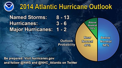
NOAA today released their 2014 Hurricane Season Forecast calling for an average to below average season...
The main driver of this year’s outlook is the anticipated development of El Niño this summer. El Niño causes stronger wind shear, which reduces the number and intensity of tropical storms and hurricanes. El Niño can also strengthen the trade winds and increase the atmospheric stability across the tropical Atlantic, making it more difficult for cloud systems coming off of Africa to intensify into tropical storms.
The outlook calls for a 50 percent chance of a below-normal season, a 40 percent chance of a near-normal season, and only a 10 percent chance of an above-normal season. For the six-month hurricane season, which begins June 1, NOAA predicts a 70 percent likelihood of 8 to 13 named storms (winds of 39 mph or higher), of which 3 to 6 could become hurricanes (winds of 74 mph or higher), including 1 to 2 major hurricanes (Category 3, 4 or 5; winds of 111 mph or higher). Read the entire article HERE.
Colorado State University and The Weather Channel also fall in line with NOAA predicting below average seasons...
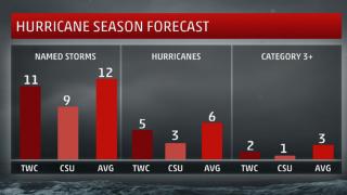
According to Dr. Phillip J. Klotzbach and Dr. William Gray of Colorado State University (CSU) in its annual preseason forecast released Thursday, the team expects a total of nine named storms, three hurricanes and one major hurricane (Category 3 or higher) in the Atlantic Ocean basin. This forecast is below the long-term average of 12 named storms, six hurricanes and three major hurricanes each season. While TWC is calling for 11 named storms, 5 of those becoming Hurricanes with only 2 becoming major Hurricanes. Read more about their forecasts HERE.
Seems the only organization predicting an above average season is Global Weather Oscillations Inc. (GWO), a leading hurricane and climate cycle Prediction Company, and the only organization that was correct in predicting the weak 2013 season! CEO David Dilley, Ocala, FL, says the upcoming season will be stronger and more dangerous than last year, with 17 named storms, 8 hurricanes and 3 major hurricanes. This will be an about face from 2013 which saw the development and strength of tropical storm and hurricane activity suppressed by hostile upper atmospheric wind shear. An average hurricane season has 12 named storms, 6 hurricanes and 3 major hurricanes. Read the entire article HERE.
WeatherBELL's forecast is calling for an average season...
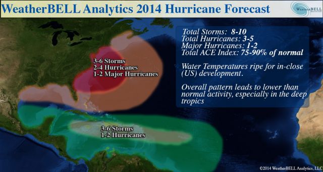
Named Storms: 8-10
Hurricanes: 3-5
Major Hurricanes: 1-2
ACE: 75-90% of normal
The deep tropics (south of 22.5°N) will have less to much-less than normal activity this year. Farther north, the very warm water off of the Eastern Seaboard is a concern, along with the oncoming El Niño conditions. There have been plenty of El Niño years with high impact seasons for the U.S. coast: 1957, 1965, 1969, 1976, 1983 (fading but still there), 1991, 1992, 2002, and 2004 are examples. The pattern favors stronger storms (relative to normals) in-close to the U.S. rather than in the deep tropics.
The ECMWF model is in strong agreement with this. Last year, it actually rang a warning bell with its forecast for near normal activity (it also did in 2012, but wasn't too accurate that year). This year, the ECMWF March tropical forecast is lower than those years.
What is different is that the ECMWF model has a forecast for higher than average activity near the East Coast of the U.S.! We have been in awe at the lack of activity near the East Coast over the last 20 years, given the similar cycle to the 1950s. While Irene and Sandy have drawn significant attention, they were nothing compared to the meteorological mayhem of the 1950s or the intensity of 1938 and 1944. There is nothing to prohibit another Sandy-type hit from the southeast or three storms up the East Coast in one year despite a relatively low number of named storms in a season. The benchmark year on the eastern seaboard, 1954, had well below normal tropical activity in the deep tropics, with only Hazel being a strong storm south of 20°N, so there is strong historical support for the ECMWF's idea.
The combination of dry air, what looks to be a relatively colder AMO index, a poor setup for the Indian Ocean wave train, and the oncoming El Niño all argue against higher than normal frequency in the deep tropics. We think this a challenging year, one that has a greater threat of higher intensity storms closer to the coast, and, where like 2012, warnings will frequently be issued with the first official NHC advisory. Read more HERE.
Tagged 2014, Colorado State, CSU, Cyclones, El nino, Forecasts, GWO, Hurricane, Predictions, Season, The Weather Channel, Tropical, TWC, Weather, Weatherbell