SUPPORT TRACK THE TROPICS
Over the last decade plus if you appreciate the information and tracking I provide during the season along with this website which donations help keep it running please consider a one time... recurring or yearly donation if you are able to help me out...
Venmo: @TrackTheTropicsLouisiana
Website: TrackTheTropics.com/DONATE
Venmo: @TrackTheTropicsLouisiana
Website: TrackTheTropics.com/DONATE
Track The Tropics is the #1 source to track the tropics 24/7! Since 2013 the main goal of the site is to bring all of the important links and graphics to ONE PLACE so you can keep up to date on any threats to land during the Atlantic Hurricane Season! Hurricane Season 2025 in the Atlantic starts on June 1st and ends on November 30th. Do you love Spaghetti Models? Well you've come to the right place!! Remember when you're preparing for a storm: Run from the water; hide from the wind!
Tropical Atlantic Weather Resources
- NOAA National Hurricane Center
- International Meteorology Database
- FSU Tropical Cyclone Track Probabilities
- Brian McNoldy Atlantic Headquarters
- Brian McNoldy Tropical Satellite Sectors
- Brian McNoldy Infrared Hovmoller
- Brian McNoldy Past TC Radar Loops
- Weather Nerds TC Guidance
- Twister Data Model Guidance
- NOAA Tropical Cyclone Tracks
- Albany GFS/ EURO Models/ Ensembles
- Albany Tropical Cyclone Guidance
- Albany Tropical Atlantic Model Maps
- Pivotal Weather Model Guidance
- Weather Online Model Guidance
- UKMet Model Guidance/ Analysis/ Sat
- ECMWF (EURO) Model Guidance
- FSU Tropical Model Outputs
- FSU Tropical Cyclone Genesis
- Penn State Tropical E-Wall
- NOAA HFIP Ruc Models
- Navy NRL TC Page
- College of DuPage Model Guidance
- WXCharts Model Guidance
- NOAA NHC Analysis Tools
- NOAA NHC ATCF Directory
- NOAA NCEP/EMC Cyclogenesis Tracking
- NOAA NCEP/EMC HWRF Model
- NOAA HFIP Model Products
- University of Miami Ocean Heat
- COLA Max Potential Hurricane Intensity
- Colorado State RAMMB TC Tracking
- Colorado State RAMMB Floaters
- Colorado State RAMMB GOES-16 Viewer
- NOAA NESDIS GOES Satellite
- ASCAT Ocean Surface Winds METOP-A
- ASCAT Ocean Surface Winds METOP-B
- Michael Ventrice Waves / MJO Maps
- TropicalAtlantic.com Analysis / Recon
- NCAR/RAL Tropical Cyclone Guidance
- CyclonicWX Tropical Resources
Historic Louisiana Storms By Month
January
June
July
August
September
October
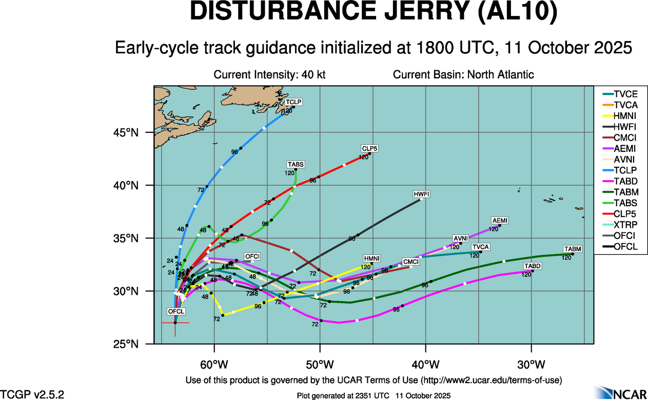
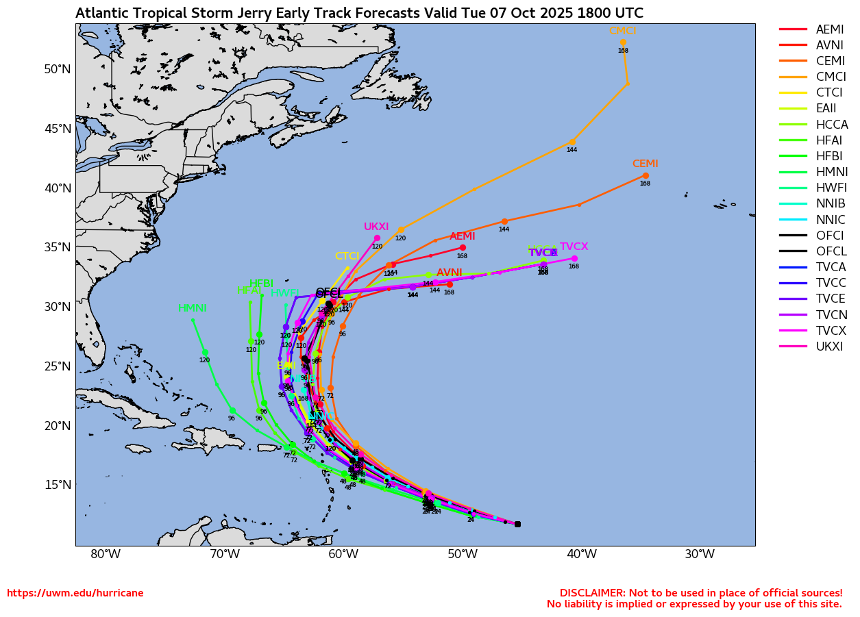
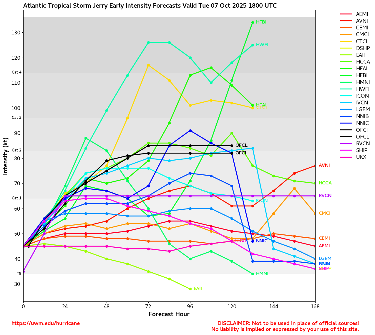
Tracking Jerry – 2025 Atlantic Hurricane Season
NHC Important Links: NHC Discussion / Public Advisory / Forecast Advisory / Wind Probs / NWS Local Products / US Watch/Warning / Graphics / Storm Archive
Storm Tracking Important Links:
Wind Analysis /
Coastal Inundation Info /
Tide Information /
Surge Map /
Surge Potential /
Coastal Risk Map /
Microwave Imagery /
Advanced Dvorak ADT /
GOES19 Satellite Storm Page /
FSU Track Probability /
Colorado State Tracker
/
Navy NRL Page
/
NHC Best Track
/
NOAA AOML Tracker
/
Tropical Atlantic
/
NCAR Guidance Page /
CyclonicWX
/
CIMSS Tracker
/ Tropical Tidbits
/ UWM Tracker
/ WeatherNerds
NOAA NESDIS Floaters


 Other Floaters:WeatherNerds - NRL Floaters - CyclonicWx - RAMMB Sat -
RAMMB Model Data -
RAMMB Wind Products


 Other Floaters:WeatherNerds - NRL Floaters - CyclonicWx - RAMMB Sat -
RAMMB Model Data -
RAMMB Wind Products
234 Visitors Tracking The Tropics in the past hour!
SUPPORT TRACK THE TROPICS
Over the last decade plus if you appreciate the information and tracking I provide during the season along with this website which donations help keep it running please consider a one time... recurring or yearly donation if you are able to help me out...
NHC Public Advisory
- Sat, 11 Oct 2025 20:33:10 +0000: Atlantic Remnants of Jerry Advisory Number 18 - Atlantic Remnants of Jerry Advisory Number 18
475
WTNT35 KNHC 112033
TCPAT5
BULLETIN
Remnants Of Jerry Advisory Number 18
NWS National Hurricane Center Miami FL AL102025
500 PM AST Sat Oct 11 2025
...JERRY DEGENERATES INTO A TROUGH...
...THIS IS THE LAST ADVISORY...
SUMMARY OF 500 PM AST...2100 UTC...INFORMATION
----------------------------------------------
LOCATION...27.6N 63.6W
ABOUT 330 MI...535 KM SSE OF BERMUDA
MAXIMUM SUSTAINED WINDS...45 MPH...75 KM/H
PRESENT MOVEMENT...N OR 360 DEGREES AT 16 MPH...26 KM/H
MINIMUM CENTRAL PRESSURE...1005 MB...29.68 INCHES
WATCHES AND WARNINGS
--------------------
There are no coastal watches or warnings in effect.
DISCUSSION AND OUTLOOK
----------------------
At 500 PM AST (2100 UTC), the remnants of Jerry were located near
latitude 27.6 North, longitude 63.6 West. The remnants are moving
toward the north near 16 mph (26 km/h) but are expected to turn
toward the northeast over the next couple of days.
Maximum sustained winds are near 45 mph (75 km/h) with higher
gusts. The remnants are expected to continue producing gale-force
winds until it merges with a frontal boundary in a day or two.
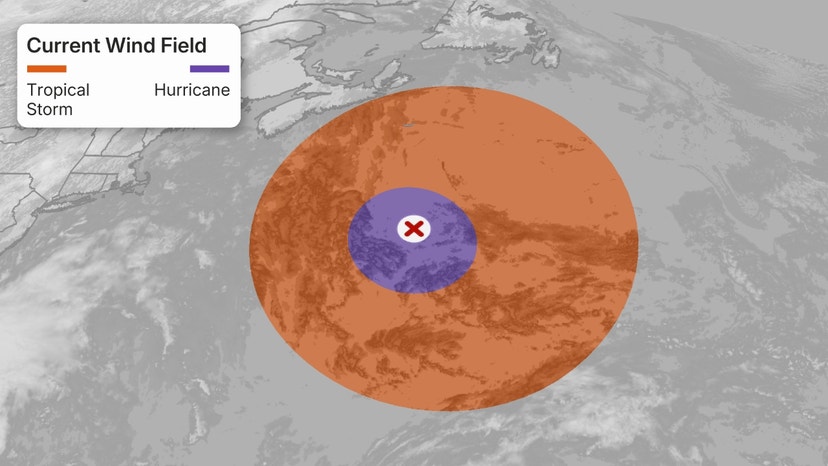
Gale-force winds extend outward up to 240 miles (390 km) to the
east of the remnant center.
The estimated minimum central pressure is 1005 mb (29.68 inches).
HAZARDS AFFECTING LAND
----------------------
SURF: Swells are affecting the Leeward Islands, Virgin Islands,
Puerto Rico, Dominican Republic, the Turks and Caicos Islands, and
the Bahamas. These swells will likely cause life-threatening surf
and rip current conditions. Please consult products from your local
weather office for more information.
A depiction of rip current risk for Puerto Rico and the U.S. Virgin
Islands can be found at:
hurricanes.gov/graphics_at5.shtml?ripCurrents
NEXT ADVISORY
-------------
This is the last public advisory issued by the National Hurricane
Center on this system. Additional information on this system can be
found in High Seas Forecasts issued by the National Weather Service,
under AWIPS header NFDHSFAT1, WMO header FZNT01 KWBC, and online at
ocean.weather.gov/shtml/NFDHSFAT1.php
$$
Forecaster Berg
NHC Forecast Advisory
- Sat, 11 Oct 2025 20:32:42 +0000: Atlantic Remnants of Jerry Forecast/Advisory Numbe... - Atlantic Remnants of Jerry Forecast/Advisory Number 18
000
WTNT25 KNHC 112032
TCMAT5
REMNANTS OF JERRY FORECAST/ADVISORY NUMBER 18
NWS NATIONAL HURRICANE CENTER MIAMI FL AL102025
2100 UTC SAT OCT 11 2025
REMNANTS OF CENTER LOCATED NEAR 27.6N 63.6W AT 11/2100Z
POSITION ACCURATE WITHIN 60 NM
PRESENT MOVEMENT TOWARD THE NORTH OR 360 DEGREES AT 14 KT
ESTIMATED MINIMUM CENTRAL PRESSURE 1005 MB
MAX SUSTAINED WINDS 40 KT WITH GUSTS TO 50 KT.
34 KT.......150NE 210SE 0SW 0NW.
4 M SEAS....180NE 180SE 90SW 150NW.
WINDS AND SEAS VARY GREATLY IN EACH QUADRANT. RADII IN NAUTICAL
MILES ARE THE LARGEST RADII EXPECTED ANYWHERE IN THAT QUADRANT.
REPEAT...CENTER LOCATED NEAR 27.6N 63.6W AT 11/2100Z
AT 11/1800Z CENTER WAS LOCATED NEAR 27.0N 63.7W
FORECAST VALID 12/0600Z...DISSIPATED
REQUEST FOR 3 HOURLY SHIP REPORTS WITHIN 300 MILES OF 27.6N 63.6W
THIS IS THE LAST FORECAST/ADVISORY ISSUED BY THE NATIONAL HURRICANE
CENTER ON THIS SYSTEM. ADDITIONAL INFORMATION ON THIS SYSTEM CAN BE
FOUND IN HIGH SEAS FORECASTS ISSUED BY THE NATIONAL WEATHER
SERVICE...UNDER AWIPS HEADER NFDHSFAT1 AND WMO HEADER FZNT01 KWBC.
$$
FORECASTER BERG
NHC Discussion
- Sat, 11 Oct 2025 20:33:40 +0000: Atlantic Remnants of Jerry Discussion Number 18 - Atlantic Remnants of Jerry Discussion Number 18
483
WTNT45 KNHC 112033
TCDAT5
Remnants Of Jerry Discussion Number 18
NWS National Hurricane Center Miami FL AL102025
500 PM AST Sat Oct 11 2025
A combination of scatterometer data, GOES-East derived motion
winds, and a recent GPM microwave pass seems to confirm that Jerry
does not have a well-defined center and has degenerated into a
trough with deep convection located at the southeastern end of the
axis. As a result, this will be the last NHC advisory on this
system. Maximum winds are estimated to be 40 kt based on ASCAT data
from this morning.
The rough motion estimate is northward, or 360/14 kt. The remnant
trough is expected to move northward and then northeastward, with
the European, Canadian, and UKMET models showing it merging with a
frontal boundary to its north in 24-36 hours. Gale-force winds are
likely to continue to the east and north of the trough until it
merges with the front. The GFS continues to keep the remnants as a
distinct feature, but given that its initial position of the
remnants is too far to the southeast, it is still considered an
outlier solution.
Additional information on this system can be found in High Seas
Forecasts issued by the National Weather Service, under AWIPS
header NFDHSFAT1, WMO header FZNT01 KWBC, and online at
ocean.weather.gov/shtml/NFDHSFAT1.php
FORECAST POSITIONS AND MAX WINDS
INIT 11/2100Z 27.6N 63.6W 40 KT 45 MPH
12H 12/0600Z...DISSIPATED
$$
Forecaster Berg

 DONATE

