
0 Active Threats To Track
SUPPORT TRACK THE TROPICS
Over the last decade plus if you appreciate the information and tracking I provide during the season along with this website which donations help keep it running please consider a one time... recurring or yearly donation if you are able to help me out...
Venmo: @TrackTheTropicsLouisiana
Website: TrackTheTropics.com/DONATE
Venmo: @TrackTheTropicsLouisiana
Website: TrackTheTropics.com/DONATE
Track The Tropics is the #1 source to track the tropics 24/7! Since 2013 the main goal of the site is to bring all of the important links and graphics to ONE PLACE so you can keep up to date on any threats to land during the Atlantic Hurricane Season! Hurricane Season 2025 in the Atlantic starts on June 1st and ends on November 30th. Do you love Spaghetti Models? Well you've come to the right place!! Remember when you're preparing for a storm: Run from the water; hide from the wind!
Tropical Atlantic Weather Resources
- NOAA National Hurricane Center
- International Meteorology Database
- FSU Tropical Cyclone Track Probabilities
- Brian McNoldy Atlantic Headquarters
- Brian McNoldy Tropical Satellite Sectors
- Brian McNoldy Infrared Hovmoller
- Brian McNoldy Past TC Radar Loops
- Weather Nerds TC Guidance
- Twister Data Model Guidance
- NOAA Tropical Cyclone Tracks
- Albany GFS/ EURO Models/ Ensembles
- Albany Tropical Cyclone Guidance
- Albany Tropical Atlantic Model Maps
- Pivotal Weather Model Guidance
- Weather Online Model Guidance
- UKMet Model Guidance/ Analysis/ Sat
- ECMWF (EURO) Model Guidance
- FSU Tropical Model Outputs
- FSU Tropical Cyclone Genesis
- Penn State Tropical E-Wall
- NOAA HFIP Ruc Models
- Navy NRL TC Page
- College of DuPage Model Guidance
- WXCharts Model Guidance
- NOAA NHC Analysis Tools
- NOAA NHC ATCF Directory
- NOAA NCEP/EMC Cyclogenesis Tracking
- NOAA NCEP/EMC HWRF Model
- NOAA HFIP Model Products
- University of Miami Ocean Heat
- COLA Max Potential Hurricane Intensity
- Colorado State RAMMB TC Tracking
- Colorado State RAMMB Floaters
- Colorado State RAMMB GOES-16 Viewer
- NOAA NESDIS GOES Satellite
- ASCAT Ocean Surface Winds METOP-A
- ASCAT Ocean Surface Winds METOP-B
- Michael Ventrice Waves / MJO Maps
- TropicalAtlantic.com Analysis / Recon
- NCAR/RAL Tropical Cyclone Guidance
- CyclonicWX Tropical Resources
2018 Hurricane Season Forecasts
The 2018 hurricane season begins June 1.
Most initial forecasts project that the number of storms will be above average, and several forecasts indicate an above-average likelihood that a major hurricane will make landfall in the Caribbean, the Gulf Coast, or the US East Coast. For residents still picking up after the hurricanes Harvey, Irma, and Maria, that would be too soon.
Before the 2017 hurricane season started, forecasts from the National Oceanic and Atmospheric Administration, Colorado State University's Tropical Meteorology Project, and The Weather Channel had pegged that year as likely to be above average but not extreme. It turned out to be one of the most disastrous, extremely active hurricane seasons on record. The 2017 Atlantic hurricane season was a hyperactive and catastrophic hurricane season, featuring 17 named storms, 10 hurricanes and 6 major hurricanes – ranking it alongside 1936 as the fifth-most active season since records began in 1851. The season also featured both the highest total accumulated cyclone energy (ACE) and the highest number of major hurricanes since 2005. All ten of the season's hurricanes occurred in a row, the greatest number of consecutive hurricanes in the satellite era, and tied for the greatest number of consecutive hurricanes ever observed in the Atlantic basin since records began in 1851. In addition, it was by far the costliest season on record, with a total of at least $282.16 billion (USD) in damages, about $100 billion higher than the total of the previous record holder — the 2005 season. In addition, essentially all of the season's damage was due to three of the season's major hurricanes — Harvey, Irma, and Maria. This season is also one of only six years on record to feature multiple Category 5 hurricanes, and only the second after 2007 to feature two hurricanes making landfall at that intensity. This season is the only season on record in which three hurricanes each had an ACE of over 40: Irma, Jose, and Maria.
Below are the 2018 seasonal forecasts from all of the major organizations...
Hurricanes in the Atlantic are formed by a confluence of global conditions, including ocean temperatures in both the Atlantic and the Pacific (which can affect winds), long-term ocean currents, and atmospheric winds. Right now, the western Atlantic is abnormally warm, but the eastern and northern Atlantic are abnormally cool. A weak La Niña event in the Pacific (which means that waters are cool) is expected to transition to a state of "ENSO-neutral," meaning there won't be any La Niña or El Niño conditions. That was the situation last year as well.
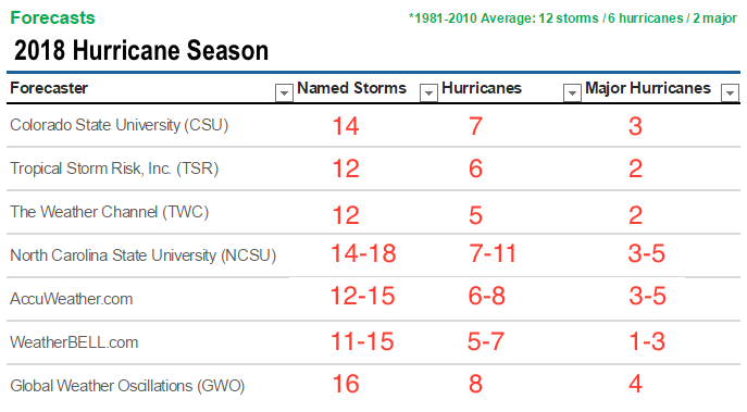
Colorado State University (CSU) is forecasting a ABOVE AVERAGE Season with a total of 14 named storms, 7 hurricanes which 3 of those will be major hurricanes and an Accumulated Cyclone Energy (ACE) of 130. The CSU outlook also calls for a 63% chance of a major hurricane hitting the U.S. in 2018, with a 39% chance for the East Coast and Florida Peninsula and a 38% chance for the Gulf Coast. The Caribbean is forecast to have a 52% chance of seeing at least one major hurricane. The forecast prepared by the CSU Tropical Meteorology Project, headed by Dr. Phil Klotzbach is slightly ABOVE the 30 year average from 1981 - 2010. They are saying the current weak La Niña event appears likely to transition to neutral ENSO over the next several months, but at this point, we do not anticipate a significant El Niño event this summer/fall.
Tropical Storm Risk, Inc. (TSR) is forecasting an AVERAGE Season with a total of 12 named storms, 6 hurricanes which 2 of those will be major hurricanes. ACE index at an 84. They project that two named storms and one hurricanee will hit the U.S. The averages from the 1950-2016 climatology are three named storms and one hurricane. Their average forecast is the anticipated development of cooler than normal sea surface temperatures in the tropical North Atlantic and Caribbean Sea by the summer/autumn of 2018.
The Weather Channel (TWC) is forecasting a NEAR AVERAGE Season with a total of 12 named storms, 5 hurricanes which 2 of those will be major hurricanes. Their forecast is based on projected cooler water temperatures in the Atlantic and warmer temperatures in the Pacific which could hamper activity. They emphasize regardless of the forecast, it only takes one storm to claim lives and property. Always stay prepared and alert.
North Carolina State University (NCSU) also released their forecast predicting a ABOVE AVERAGE season with a total of 14–18 named storms, 7–11 hurricanes which they say 3–5 will be major hurricanes. Noting that this year’s numbers for the Gulf are also ABOVE the average of three named storms. NCSU data indicate the likelihood of five to six named storms forming in the region, with one to two of the storms becoming a hurricane.
AccuWeather.com is forecasting an AVERAGE TO ABOVEaverage Season with 12-15 named storms, 6-8 of which are projected to become hurricanes and 3-5 of which may become major hurricanes. They say we are in a weakening La Niña pattern, but the climate pattern is expected to go into what’s called a neutral pattern, which promotes near-normal wind shear. But they also note the thing that’s causing the balance to tip in one direction [this year] is that sea surface temperatures are warmer than normal.
WeatherBELL.com is forecasting in between a BELOW to ABOVE average Season with 11-15 named storms, 5-7 hurricanes which 1-3 of those becoming major hurricanes and an Accumulated Cyclone Energy (ACE) of 90-110. WeatherBELL says as far as impact, unlike last year when we plainly had the U.S. in the cross-hairs, this year it looks like the U.S. will be on the western edge of the highest ACE area (50% or more). This will extend between 30°N and 40°N from the U.S. coast to 55°W. If I had to draw it today, the centering of the area of greatest activity would not be like last year. Look for storms to be stronger farther to the north and east than 2017.
Global Weather Oscillations (GWO) is forecasting just like they did last year a ABOVE average Season. NOTE: GWO was the only organization to predict an ABOVE average Season in 2017. GWO is predicting that 2018 will look a lot like 2017 with respects to hurricane season. In fact, GWO is predicting that this coming hurricane season could be another record breaker. They are predicting a total of 16 named storms. 8 of which will become hurricanes and 4 of those hurricanes will become major hurricanes. The predict that 2 of those major hurricanes will impact United States. GWO says that due to the similar ocean temperatures as last year in the Caribbean and Atlanta regions near the United States it creates a more favorable environment for tropical storms to form. These storms grow in strength as they move towards the United States. The experts at GWO have an incredible reputation based on their results last hurricane season. With this type of notice this far in advance, people must take action and prepare themselves early.
Here are the official 2018 Names: Alberto, Beryl, Chris, Debby, Ernesto, Florence, Gordon, Helene, Isaac, Joyce, Kirk, Leslie, Michael, Nadine, Oscar, Patty, Rafael, Sara, Tony, Valerie, William
Note: There is no strong correlation between the number of storms or hurricanes and U.S. landfalls in any given season. One or more of the named storms forecast to develop this season could hit the U.S., or none at all. Therefore, residents of the coastal United States should prepare each year no matter the forecast.
A couple of classic examples of why you need to be prepared each year occurred in 1992 and 1983. The 1992 season produced only six named storms and one subtropical storm. However, one of those named storms was Hurricane Andrew, which devastated South Florida as a Category 5 hurricane. In 1983 there were only four named storms, but one of them was Alicia. The Category 3 hurricane hit the Houston-Galveston area and caused almost as many direct fatalities there as Andrew did in South Florida.
In contrast, the 2010 season was active. There were 19 named storms and 12 hurricanes that formed in the Atlantic Basin. Despite the large number of storms that year, not a single hurricane and only one tropical storm made landfall in the United States.
In other words, a season can deliver many storms, but have little impact, or deliver few storms and have one or more hitting the U.S. coast with major impact. So ALWAYS BE ALERT AND PREPARED NO MATTER WHAT THE FORECAST IS! You can rely on Track The Tropics EVERY YEAR to bring you the latest and most accurate information on Hurricane Season 24/7... STAY TUNED!!
Tagged 2018, Active, forecast, Hurricane, Hurricane Season, Names, Season, Track The Tropics, Tropical, Tropical Storm, Tropics