
1927 Visitors Tracking The Tropics!

SHOW ME SOME LOVE AND SUPPORT
Website: TrackTheTropics.com/DONATE
Venmo: @TrackTheTropicsLouisiana
Cash App: Cash.App/$TrackTheTropics
Subscribe: FB.com/TrackTheTropics
 MAIN DONATION PAGE
Website: TrackTheTropics.com/DONATE
Venmo: @TrackTheTropicsLouisiana
Cash App: Cash.App/$TrackTheTropics
Subscribe: FB.com/TrackTheTropics
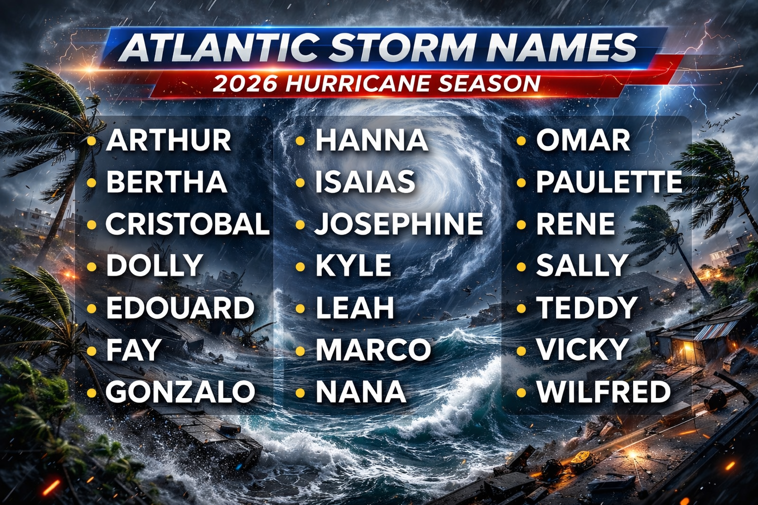

Track The Tropics is the #1 source to track the tropics 24/7! Since 2013 the main goal of the site is to bring all of the important links and graphics to ONE PLACE so you can keep up to date on any threats to land during the Atlantic Hurricane Season! Hurricane Season 2026 in the Atlantic starts on June 1st and ends on November 30th. Do you love Spaghetti Models? Well you've come to the right place!! Remember when you're preparing for a storm: Run from the water; hide from the wind!
Tropical Atlantic Weather Resources
- NOAA National Hurricane Center
- International Meteorology Database
- FSU Tropical Cyclone Track Probabilities
- Brian McNoldy Atlantic Headquarters
- Brian McNoldy Tropical Satellite Sectors
- Brian McNoldy Infrared Hovmoller
- Brian McNoldy Past TC Radar Loops
- Weather Nerds TC Guidance
- Twister Data Model Guidance
- NOAA Tropical Cyclone Tracks
- Albany GFS/ EURO Models/ Ensembles
- Albany Tropical Cyclone Guidance
- Albany Tropical Atlantic Model Maps
- Pivotal Weather Model Guidance
- Weather Online Model Guidance
- UKMet Model Guidance/ Analysis/ Sat
- ECMWF (EURO) Model Guidance
- FSU Tropical Model Outputs
- FSU Tropical Cyclone Genesis
- Penn State Tropical E-Wall
- NOAA HFIP Ruc Models
- Navy NRL TC Page
- College of DuPage Model Guidance
- WXCharts Model Guidance
- NOAA NHC Analysis Tools
- NOAA NHC ATCF Directory
- NOAA NCEP/EMC Cyclogenesis Tracking
- NOAA NCEP/EMC HWRF Model
- NOAA HFIP Model Products
- University of Miami Ocean Heat
- COLA Max Potential Hurricane Intensity
- Colorado State RAMMB TC Tracking
- Colorado State RAMMB Floaters
- Colorado State RAMMB GOES-16 Viewer
- NOAA NESDIS GOES Satellite
- ASCAT Ocean Surface Winds METOP-A
- ASCAT Ocean Surface Winds METOP-B
- Michael Ventrice Waves / MJO Maps
- TropicalAtlantic.com Analysis / Recon
- NCAR/RAL Tropical Cyclone Guidance
- CyclonicWX Tropical Resources
Earn CASH Back On Gas $$$$ 
Shop Store For Essentials
Historic Louisiana Storms By Month
January
June
July
August
September
October
Tracking Sean – 2023 Atlantic Hurricane Season
NHC Important Links: NHC Discussion / Public Advisory / Forecast Advisory / Wind Probs / Graphics / Storm Archive
Storm Tracking Important Links:
Wind Analysis /
Coastal Inundation Info /
Tide Information /
Surge Map /
Surge Potential /
Coastal Risk Map /
Microwave Imagery /
Advanced Dvorak ADT /
GOES16 Satellite Storm Page /
FSU Track Probability /
NOAA Tracker /
Albany Tracker /
Navy NRL Page /
HFIP Products /
Tropical Atlantic Storm Page /
NCAR Guidance Page /
CyclonicWX Tracker /
CIMSS Tracker / Tropical Tidbits Storm Page /UWM Tracker / SFWMD Models
Projected Path with Watches and Warnings

Projected Path with Watches and Warnings

Most Likely Arrival Time of Tropical Storm Force Winds

Microwave Imagery

NOAA NESDIS Floaters


Average Days For System To Reach U.S.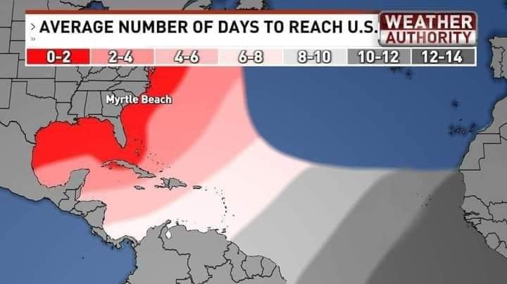
Most Reasonable Arrival Time of Tropical Storm Force Winds

Hurricane Force Wind Probabilities

Tropical Storm Force Wind Probabilities

Windshear Around Storm

Dry Air/ Water Vapor Around Storm

Past Track History

Top Analog Tracks

Surface Wind Field

Cumulative Wind History

WeatherNerds.org Floaters

|

|

|

|
Other Floater Sites:
TropicalTidbits - NRL Floaters - CyclonicWx - RAMMB Sat - RAMMB Model Data - RAMMB Wind Products
TropicalTidbits - NRL Floaters - CyclonicWx - RAMMB Sat - RAMMB Model Data - RAMMB Wind Products
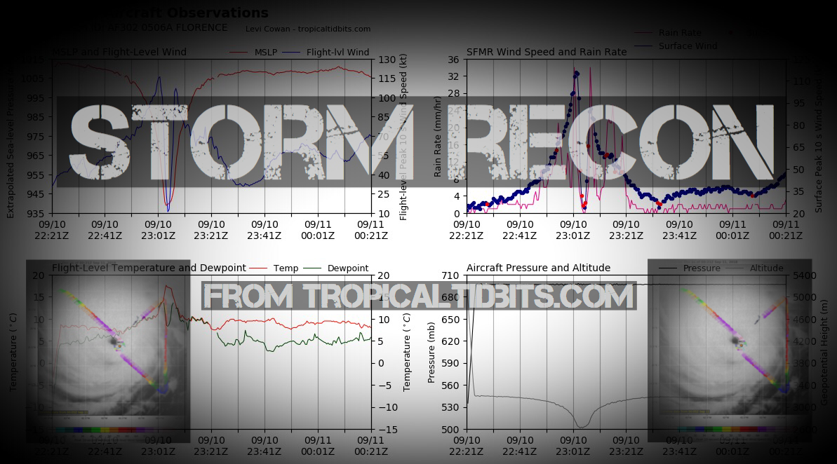
Intensity Forecasts

Model Tracks


GFS / Canadian Ensemble Tracks

EURO Ensemble Tracks
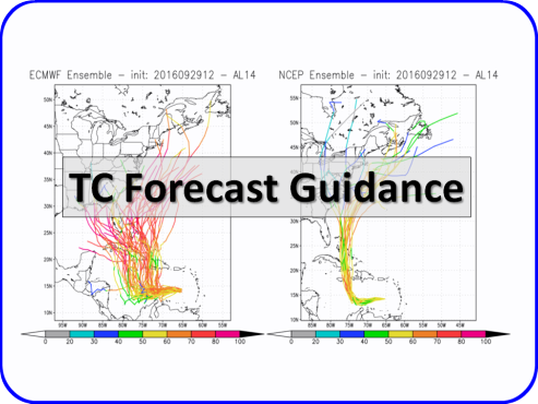
EPS Ensemble Tracks

- Wed, 07 Oct 2026 08:52:28 +0000: Atlantic Tropical Storm Isaias Advisory Number 3 - Atlantic Tropical Storm Isaias Advisory Number 3
000
WTNT34 KNHC 070852
TCPAT4
BULLETIN
Tropical Storm Isaias Advisory Number 3
NWS National Hurricane Center Miami FL AL092026
400 AM CDT Wed Oct 07 2026
...DEPRESSION BECOMES TROPICAL STORM ISAIAS...
...FORECAST TO RAPIDLY STRENGTHEN OVER THE NEXT COUPLE OF DAYS...
SUMMARY OF 400 AM CDT...0900 UTC...INFORMATION
----------------------------------------------
LOCATION...22.0N 94.1W
ABOUT 285 MI...460 KM W OF PROGRESO MEXICO
ABOUT 580 MI...935 KM SW OF THE MOUTH OF THE MISSISSIPPI RIVER
MAXIMUM SUSTAINED WINDS...40 MPH...65 KM/H
PRESENT MOVEMENT...ENE OR 75 DEGREES AT 8 MPH...13 KM/H
MINIMUM CENTRAL PRESSURE...1004 MB...29.65 INCHES
WATCHES AND WARNINGS
--------------------
There are no coastal watches or warnings in effect.
Interests in the Yucatan Peninsula of Mexico and the U.S. northern
Gulf Coast should closely monitor the progress of this system.
Hurricane Watches will likely be required for a portion of the U.S.
northern Gulf coast later today.
DISCUSSION AND OUTLOOK
----------------------
At 400 AM CDT (0900 UTC), the center of Tropical Storm Isaias was
located near latitude 22.0 North, longitude 94.1 West. Isaias is
moving toward the east-northeast near 8 mph (13 km/h). A continued
east-northeastward motion is expected today, followed by a turn
toward the northeast and north on Thursday and Friday. On the
forecast track, Isaias is expected to pass to the north of the
Yucatan Peninsula on Thursday and approach the U.S. northern Gulf
Coast on Friday.
Maximum sustained winds have increased to near 40 mph (65 km/h) with
higher gusts. Rapid strengthening is forecast over the next day or
two, and Isaias is expected to become a hurricane by Thursday.
Tropical-storm-force winds extend outward up to 45 miles (75 km)
from the center.
The estimated minimum central pressure is 1004 mb (29.65 inches).
HAZARDS AFFECTING LAND
----------------------
Key messages for Isaias can be found in the Tropical Cyclone
Discussion under AWIPS header MIATCDAT4 and WMO header WTNT44 KNHC.
RAINFALL: Isaias is expected to produce rainfall amounts of 2 to 4
inches through Thursday across coastal portions of the Bay of
Campeche with isolated higher amounts possible in the states of
Campeche and western Yucatan.
From Friday through the weekend, Isaias is expected to produce
rainfall amounts of 3 to 6 inches, with localized totals up to 10
inches, across the northern U.S. Gulf Coast extending from far
southeastern Louisiana to the Florida Panhandle. Rainfall amounts of
1 to 3 inches, with localized amounts up to 5 inches, are possible
across much of the Southeast as far north as the Tennessee Valley
and the Carolinas. Flash and urban flooding, along with isolated
river flooding, will be possible.
For a complete depiction of forecast rainfall associated with
Isaias, please see the National Weather Service Storm Total Rainfall
Graphic available at hurricanes.gov/graphics_at4.shtml?rainqpf and
the Flash Flood Risk graphic at
hurricanes.gov/graphics_at4.shtml?ero.
WIND: Gusty winds are possible in portions of the Yucatan Peninsula
on Thursday.
SURF: Swells are expected to affect the western and northern
portions of the Yucatan Peninsula beginning on Thursday and spread
northward toward the Gulf Coast late this week. These swells are
likely to cause life-threatening surf and rip current conditions.
Please consult products from your local weather office.
A depiction of rip current risk for the United States can be found
at: hurricanes.gov/graphics_at4.shtml?ripCurrents
NEXT ADVISORY
-------------
Next complete advisory at 1000 AM CDT.
$$
Forecaster Papin
- Wed, 07 Oct 2026 08:49:58 +0000: Atlantic Tropical Storm Isaias Forecast/Advisory N... - Atlantic Tropical Storm Isaias Forecast/Advisory Number 3
000
WTNT24 KNHC 070849
TCMAT4
TROPICAL STORM ISAIAS FORECAST/ADVISORY NUMBER 3
NWS NATIONAL HURRICANE CENTER MIAMI FL AL092026
0900 UTC WED OCT 07 2026
TROPICAL STORM CENTER LOCATED NEAR 22.0N 94.1W AT 07/0900Z
POSITION ACCURATE WITHIN 30 NM
PRESENT MOVEMENT TOWARD THE EAST-NORTHEAST OR 75 DEGREES AT 7 KT
ESTIMATED MINIMUM CENTRAL PRESSURE 1004 MB
MAX SUSTAINED WINDS 35 KT WITH GUSTS TO 45 KT.
34 KT....... 40NE 0SE 0SW 40NW.
WINDS AND SEAS VARY GREATLY IN EACH QUADRANT. RADII IN NAUTICAL
MILES ARE THE LARGEST RADII EXPECTED ANYWHERE IN THAT QUADRANT.
REPEAT...CENTER LOCATED NEAR 22.0N 94.1W AT 07/0900Z
AT 07/0600Z CENTER WAS LOCATED NEAR 21.8N 94.5W
FORECAST VALID 07/1800Z 22.2N 92.9W
MAX WIND 50 KT...GUSTS 60 KT.
50 KT... 0NE 15SE 20SW 20NW.
34 KT... 60NE 40SE 40SW 60NW.
FORECAST VALID 08/0600Z 22.7N 91.4W
MAX WIND 65 KT...GUSTS 80 KT.
64 KT... 0NE 10SE 10SW 0NW.
50 KT... 25NE 25SE 25SW 20NW.
34 KT... 80NE 70SE 50SW 70NW.
FORECAST VALID 08/1800Z 23.9N 89.7W
MAX WIND 80 KT...GUSTS 100 KT.
50 KT... 35NE 35SE 30SW 30NW.
34 KT...110NE 100SE 70SW 90NW.
FORECAST VALID 09/0600Z 25.5N 88.5W
MAX WIND 95 KT...GUSTS 115 KT.
64 KT... 25NE 30SE 25SW 25NW.
50 KT... 50NE 55SE 40SW 45NW.
34 KT...140NE 120SE 80SW 130NW.
FORECAST VALID 09/1800Z 27.7N 87.7W
MAX WIND 90 KT...GUSTS 110 KT.
64 KT... 35NE 35SE 30SW 30NW.
50 KT... 60NE 55SE 40SW 50NW.
34 KT...140NE 130SE 80SW 120NW.
FORECAST VALID 10/0600Z 30.8N 87.7W...INLAND
MAX WIND 75 KT...GUSTS 90 KT.
64 KT... 20NE 25SE 15SW 15NW.
50 KT... 50NE 45SE 35SW 45NW.
34 KT...120NE 110SE 60SW 90NW.
EXTENDED OUTLOOK. NOTE...ERRORS FOR TRACK HAVE AVERAGED NEAR 125 NM
ON DAY 4 AND 175 NM ON DAY 5...AND FOR INTENSITY NEAR 15 KT EACH DAY
OUTLOOK VALID 11/0600Z 38.2N 87.5W...POST-TROP/INLAND
MAX WIND 25 KT...GUSTS 35 KT.
OUTLOOK VALID 12/0600Z...DISSIPATED
REQUEST FOR 3 HOURLY SHIP REPORTS WITHIN 300 MILES OF 22.0N 94.1W
NEXT ADVISORY AT 07/1500Z
$$
FORECASTER PAPIN
- Wed, 07 Oct 2026 08:57:59 +0000: Atlantic Tropical Storm Isaias Discussion Number 3 - Atlantic Tropical Storm Isaias Discussion Number 3
000
WTNT44 KNHC 070857
TCDAT4
Tropical Storm Isaias Discussion Number 3
NWS National Hurricane Center Miami FL AL092026
400 AM CDT Wed Oct 07 2026
Satellite imagery depicts a bursting pattern with the tropical
cyclone this morning, with cloud top temperatures below -85 C in the
deep convection close to the estimated center. Earlier, an 0307 UTC
ASCAT-C pass suggested the low-level circulation was still rather
broad, with a peak wind retrieval of only 31 kt. However, the
bursting convection already appears to be tightening up the
circulation somewhat, with a nearby surface observation from a buoy
north of the center recently reporting a sustained 10 m adjusted
wind of 35 kt. This information is enough to upgrade the depression
to Tropical Storm Isaias for this advisory. This initial intensity
will be 35 kt, which also agrees with the 06 UTC Dvorak fix of
T2.5/35 kt. Both Air Force Reserve and NOAA Hurricane Hunter
reconnaissance missions are scheduled to sample the tropical storm
later today.
Isaias is estimated to be moving east-northeastward this morning at
075/7 kt. This general motion should continue today as the storm's
steering is influenced by a zonally oriented mid-level trough
currently draped along the northern Gulf coast. Over time, this
trough is expected to be reinforced by another short-wave that is
moving across the Rocky Mountains, with the trough ultimately
sharpening up northwest of Isaias over Texas. At the same time, a
subtropical ridge centered south of Bermuda is expected to shift
westward, helping to enhance the deep-layer southerly flow over the
eastern Gulf. Thus, Isaias is expected to turn northeastward and
then northward on Thursday and Friday, making its approach to the
northern Gulf coast in 60-72 h. As mentioned in the previous
discussion, there remains quite a bit of along and across-track
spread in the track guidance, with the AI-model guidance remaining
on the east side, and physics-based models on the west side of the
guidance envelope. The NHC track forecast continues to favor more of
the eastward solutions, but not quite as far east as the latest HFIP
Corrected Consensus Approach (HCCA) or Google DeepMind ensemble mean
(GDMI). This latest track is a eastward shift compared to the
previous forecast, but given large amount of across- and along-track
spread users should continue to monitor forecast updates given the
below-average track confidence.
The short-term environment near Isaias is rather favorable, with
very warm 30-31 C sea-surface temperatures, plenty of deep-layer
moisture, with light to moderate shear diagnosed between 10-15 kt by
SHIPS guidance. While it is difficult to get an exact gauge on the
tropical storm's core structure since there have not been any
recent microwave images, it is worth noting both the 00 UTC HAFS-A/B
runs appeared to initialize with a broad structure similar to what
was noted in the earlier ASCAT pass. Despite their initial broad
structure, these hurricane-regional models show Isaias developing an
inner-core rather quickly later today. There was a notable increase
in the intensity aid guidance this forecast cycle, and the NHC
intensity forecast is being raised accordingly, now showing Isaias
reaching a peak intensity of 95 kt in 48 h while it is over the
central Gulf. Vertical wind shear then increases quite dramatically
in the final 24 hours before the cyclone reaches the northern Gulf
coast, though it is looking more likely that Isaias will be a
significant hurricane when it reaches the coast. Near landfall,
Isaias will also be interacting with the short-wave trough, likely
leading to an expanding wind field. Additional convective and
motion asymmetries will likely cause rain and wind impacts to
extend far from the center on the eastern side of the storm.
Key Messages:
1. There is an increasing risk of dangerous wind and storm surge
impacts along portions of the northern Gulf Coast. Residents from
Louisiana to the Florida Panhandle should closely monitor the latest
forecast updates and ensure they have their hurricane plan in place.
Hurricane and Storm Surge Watches will likely be required for a
portion of the northern Gulf coast later today.
2. Tropical Storm Isaias will bring areas of heavy rainfall to the
central U.S. Gulf coast and much of the Southeast Friday into the
weekend. Flash and urban flooding, along with isolated river
flooding, will be possible.
3. Yucatan Peninsula of Mexico: Tropical Storm Isaias is expected to
strengthen and could bring gusty winds and areas of heavy rain to
the western portion of the Yucatan Peninsula over the next day or
two.
FORECAST POSITIONS AND MAX WINDS
INIT 07/0900Z 22.0N 94.1W 35 KT 40 MPH
12H 07/1800Z 22.2N 92.9W 50 KT 60 MPH
24H 08/0600Z 22.7N 91.4W 65 KT 75 MPH
36H 08/1800Z 23.9N 89.7W 80 KT 90 MPH
48H 09/0600Z 25.5N 88.5W 95 KT 110 MPH
60H 09/1800Z 27.7N 87.7W 90 KT 105 MPH
72H 10/0600Z 30.8N 87.7W 75 KT 85 MPH...INLAND
96H 11/0600Z 38.2N 87.5W 25 KT 30 MPH...POST-TROP/INLAND
120H 12/0600Z...DISSIPATED
$$
Forecaster Papin
2 Day Tropical Weather Outlook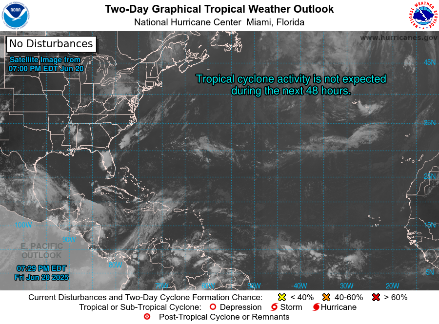
7 Day Tropical Weather Outlook