SUPPORT TRACK THE TROPICS
Over the last decade plus if you appreciate the information and tracking I provide during the season along with this website which donations help keep it running please consider a one time... recurring or yearly donation if you are able to help me out...
Venmo: @TrackTheTropicsLouisiana
Website: TrackTheTropics.com/DONATE
Venmo: @TrackTheTropicsLouisiana
Website: TrackTheTropics.com/DONATE
Track The Tropics is the #1 source to track the tropics 24/7! Since 2013 the main goal of the site is to bring all of the important links and graphics to ONE PLACE so you can keep up to date on any threats to land during the Atlantic Hurricane Season! Hurricane Season 2026 in the Atlantic starts on June 1st and ends on November 30th. Do you love Spaghetti Models? Well you've come to the right place!! Remember when you're preparing for a storm: Run from the water; hide from the wind!
Tropical Atlantic Weather Resources
- NOAA National Hurricane Center
- International Meteorology Database
- FSU Tropical Cyclone Track Probabilities
- Brian McNoldy Atlantic Headquarters
- Brian McNoldy Tropical Satellite Sectors
- Brian McNoldy Infrared Hovmoller
- Brian McNoldy Past TC Radar Loops
- Weather Nerds TC Guidance
- Twister Data Model Guidance
- NOAA Tropical Cyclone Tracks
- Albany GFS/ EURO Models/ Ensembles
- Albany Tropical Cyclone Guidance
- Albany Tropical Atlantic Model Maps
- Pivotal Weather Model Guidance
- Weather Online Model Guidance
- UKMet Model Guidance/ Analysis/ Sat
- ECMWF (EURO) Model Guidance
- FSU Tropical Model Outputs
- FSU Tropical Cyclone Genesis
- Penn State Tropical E-Wall
- NOAA HFIP Ruc Models
- Navy NRL TC Page
- College of DuPage Model Guidance
- WXCharts Model Guidance
- NOAA NHC Analysis Tools
- NOAA NHC ATCF Directory
- NOAA NCEP/EMC Cyclogenesis Tracking
- NOAA NCEP/EMC HWRF Model
- NOAA HFIP Model Products
- University of Miami Ocean Heat
- COLA Max Potential Hurricane Intensity
- Colorado State RAMMB TC Tracking
- Colorado State RAMMB Floaters
- Colorado State RAMMB GOES-16 Viewer
- NOAA NESDIS GOES Satellite
- ASCAT Ocean Surface Winds METOP-A
- ASCAT Ocean Surface Winds METOP-B
- Michael Ventrice Waves / MJO Maps
- TropicalAtlantic.com Analysis / Recon
- NCAR/RAL Tropical Cyclone Guidance
- CyclonicWX Tropical Resources
Historic Louisiana Storms By Month
January
June
July
August
September
October
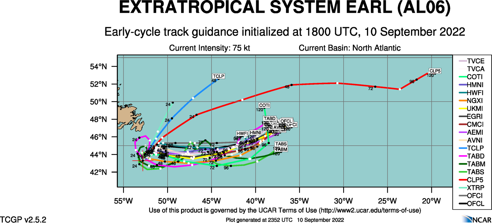
Hurricane Earl – 2022 Atlantic Hurricane Season
NHC Important Links: NHC Discussion / Public Advisory / Forecast Advisory / Wind Probs / NWS Local Products / US Watch/Warning / Graphics / Storm Archive
Storm Tracking Important Links:
Wind Analysis /
Coastal Inundation Info /
Tide Information /
Surge Map /
Surge Potential /
Coastal Risk Map /
Microwave Imagery /
Advanced Dvorak ADT /
GOES16 Satellite Storm Page /
FSU Track Probability /
NOAA Tracker /
Albany Tracker /
Navy NRL Page /
HFIP Products /
Tropical Atlantic Storm Page /
NCAR Guidance Page /
CyclonicWX Tracker /
CIMSS Tracker / Tropical Tidbits Storm Page /UWM Tracker / SFWMD Models
Other Floater Sites:
TropicalTidbits - NRL Floaters - CyclonicWx - RAMMB Sat -
RAMMB Model Data -
RAMMB Wind Products
- Fri, 10 Oct 2025 20:31:50 +0000: Atlantic Post-Tropical Cyclone Karen Advisory Number 4 - Atlantic Post-Tropical Cyclone Karen Advisory Number 4
000
WTNT31 KNHC 102031
TCPAT1
BULLETIN
Post-Tropical Cyclone Karen Advisory Number 4
NWS National Hurricane Center Miami FL AL112025
900 PM GMT Fri Oct 10 2025
...KAREN LOSES SUBTROPICAL CHARACTERISTICS OVER THE NORTH
ATLANTIC...
SUMMARY OF 900 PM GMT...2100 UTC...INFORMATION
----------------------------------------------
LOCATION...47.5N 30.2W
ABOUT 675 MI...1085 KM NNW OF THE AZORES
MAXIMUM SUSTAINED WINDS...45 MPH...75 KM/H
PRESENT MOVEMENT...NNE OR 20 DEGREES AT 16 MPH...26 KM/H
MINIMUM CENTRAL PRESSURE...1000 MB...29.53 INCHES
WATCHES AND WARNINGS
--------------------
There are no coastal watches or warnings in effect.
DISCUSSION AND OUTLOOK
----------------------
At 900 PM GMT (2100 UTC), the center of Post-Tropical Cyclone Karen
was located near latitude 47.5 North, longitude 30.2 West. The
post-tropical cyclone is moving toward the north-northeast near 16
mph (26 km/h). A faster north-northeastward motion is expected
until dissipation occurs late Saturday.
Maximum sustained winds are near 45 mph (75 km/h) with higher gusts.
Gradual weakening is forecast tonight and Saturday, and Karen should
degenerate into a trough of low pressure late Saturday.
Tropical-storm-force winds extend outward up to 45 miles (75 km)
from the center.
The estimated minimum central pressure is 1000 mb (29.53 inches).
HAZARDS AFFECTING LAND
----------------------
None.
NEXT ADVISORY
-------------
This is the last public advisory issued by the National Hurricane
Center on Karen. Additional information on this system can be found
in High Seas Forecasts issued by Meteo France under WMO header
FQNT50 LFPW and available on the web at
https://tgftp.nws.noaa.gov/data/raw/fq/fqnt50.lfpw..txt
$$
Forecaster Brown
- Fri, 10 Oct 2025 20:31:50 +0000: Atlantic Post-Tropical Cyclone Karen Forecast/Advi... - Atlantic Post-Tropical Cyclone Karen Forecast/Advisory Number 4
000
WTNT21 KNHC 102031
TCMAT1
POST-TROPICAL CYCLONE KAREN FORECAST/ADVISORY NUMBER 4
NWS NATIONAL HURRICANE CENTER MIAMI FL AL112025
2100 UTC FRI OCT 10 2025
POST-TROPICAL CYCLONE CENTER LOCATED NEAR 47.5N 30.2W AT 10/2100Z
POSITION ACCURATE WITHIN 25 NM
PRESENT MOVEMENT TOWARD THE NORTH-NORTHEAST OR 20 DEGREES AT 14 KT
ESTIMATED MINIMUM CENTRAL PRESSURE 1000 MB
MAX SUSTAINED WINDS 40 KT WITH GUSTS TO 50 KT.
34 KT....... 30NE 40SE 40SW 0NW.
4 M SEAS.... 45NE 60SE 0SW 0NW.
WINDS AND SEAS VARY GREATLY IN EACH QUADRANT. RADII IN NAUTICAL
MILES ARE THE LARGEST RADII EXPECTED ANYWHERE IN THAT QUADRANT.
REPEAT...CENTER LOCATED NEAR 47.5N 30.2W AT 10/2100Z
AT 10/1800Z CENTER WAS LOCATED NEAR 46.8N 30.6W
FORECAST VALID 11/0600Z 49.4N 29.0W...POST-TROPICAL
MAX WIND 35 KT...GUSTS 45 KT.
34 KT... 30NE 40SE 0SW 0NW.
FORECAST VALID 11/1800Z 53.5N 27.1W...POST-TROPICAL
MAX WIND 30 KT...GUSTS 40 KT.
FORECAST VALID 12/0600Z...DISSIPATED
REQUEST FOR 3 HOURLY SHIP REPORTS WITHIN 300 MILES OF 47.5N 30.2W
THIS IS THE LAST FORECAST/ADVISORY ISSUED BY THE NATIONAL HURRICANE
CENTER ON KAREN. ADDITIONAL INFORMATION ON THIS SYSTEM CAN BE FOUND
IN HIGH SEAS FORECASTS ISSUED BY METEO FRANCE...UNDER WMO HEADER
FQNT50 LFPW.
$$
FORECASTER BROWN
- Fri, 10 Oct 2025 20:32:51 +0000: Atlantic Post-Tropical Cyclone Karen Discussion Number 4 - Atlantic Post-Tropical Cyclone Karen Discussion Number 4
000
WTNT41 KNHC 102032
TCDAT1
Post-Tropical Cyclone Karen Discussion Number 4
NWS National Hurricane Center Miami FL AL112025
900 PM GMT Fri Oct 10 2025
Convection associated with Karen has dissipated this evening,
leaving the system a swirl of low- to mid-level clouds. The cyclone
will be moving over even colder waters of the North Atlantic during
the next 12 to 24 hours, and organized convection is not expected to
return. Therefore, Karen has lost its designation as a subtropical
cyclone, and this will be the last NHC advisory. The initial
intensity remains 40 kt, based on earlier ASCAT data. The low should
gradually weaken during the next 12 to 24 hours, and it is expected
to open up into a trough and be absorbed by an approaching frontal
system in 24 to 36 hours.
The low is moving north-northeastward or 025 degrees at 14 kt. The
system should continue to accelerate north-northeastward ahead of
an approaching deep-layer trough through Saturday. The updated NHC
track forecast is once again similar to the previous forecast and
near the center of the guidance envelope.
This is the last NHC advisory on Karen. Additional information on
this system can be found in High Seas Forecasts issued by Meteo
France under WMO header FQNT50 LFPW and available on the web at
https://tgftp.nws.noaa.gov/data/raw/fq/fqnt50.lfpw..txt
FORECAST POSITIONS AND MAX WINDS
INIT 10/2100Z 47.5N 30.2W 40 KT 45 MPH...POST-TROPICAL
12H 11/0600Z 49.4N 29.0W 35 KT 40 MPH...POST-TROPICAL
24H 11/1800Z 53.5N 27.1W 30 KT 35 MPH...POST-TROPICAL
36H 12/0600Z...DISSIPATED
$$
Forecaster Brown

 DONATE
