
446 Visitors Tracking The Tropics!

SHOW ME SOME LOVE AND SUPPORT
Website: TrackTheTropics.com/DONATE
Venmo: @TrackTheTropicsLouisiana
Cash App: Cash.App/$TrackTheTropics
Subscribe: FB.com/TrackTheTropics
 MAIN DONATION PAGE
Website: TrackTheTropics.com/DONATE
Venmo: @TrackTheTropicsLouisiana
Cash App: Cash.App/$TrackTheTropics
Subscribe: FB.com/TrackTheTropics
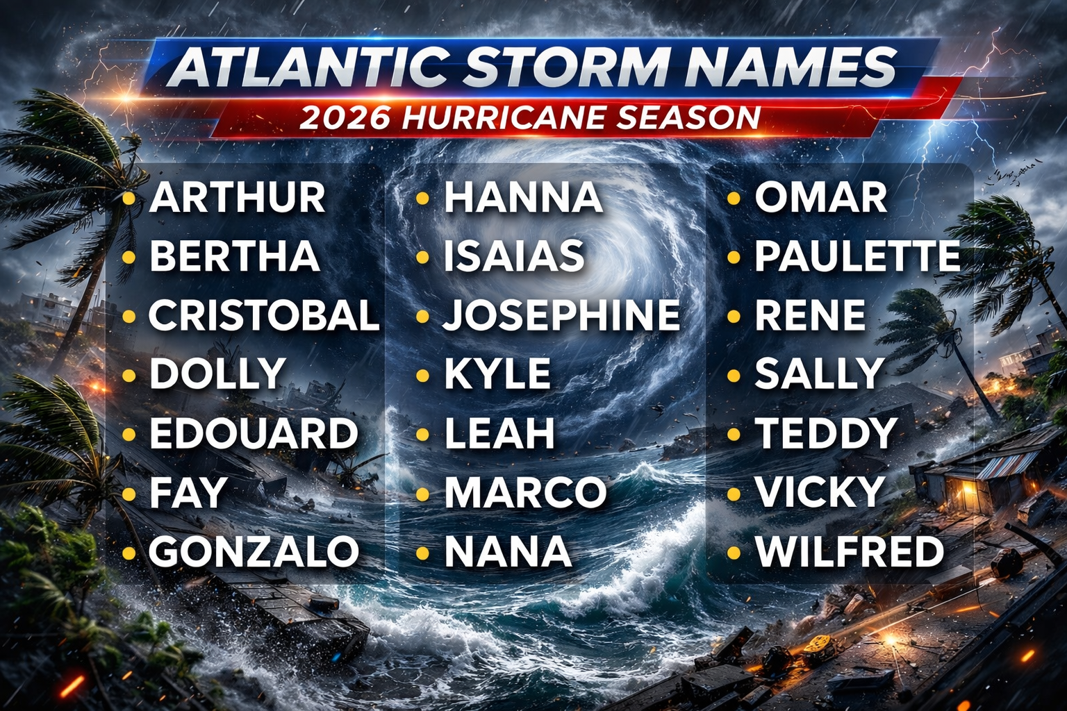

Track The Tropics is the #1 source to track the tropics 24/7! Since 2013 the main goal of the site is to bring all of the important links and graphics to ONE PLACE so you can keep up to date on any threats to land during the Atlantic Hurricane Season! Hurricane Season 2026 in the Atlantic starts on June 1st and ends on November 30th. Do you love Spaghetti Models? Well you've come to the right place!! Remember when you're preparing for a storm: Run from the water; hide from the wind!
Tropical Atlantic Weather Resources
- NOAA National Hurricane Center
- International Meteorology Database
- FSU Tropical Cyclone Track Probabilities
- Brian McNoldy Atlantic Headquarters
- Brian McNoldy Tropical Satellite Sectors
- Brian McNoldy Infrared Hovmoller
- Brian McNoldy Past TC Radar Loops
- Weather Nerds TC Guidance
- Twister Data Model Guidance
- NOAA Tropical Cyclone Tracks
- Albany GFS/ EURO Models/ Ensembles
- Albany Tropical Cyclone Guidance
- Albany Tropical Atlantic Model Maps
- Pivotal Weather Model Guidance
- Weather Online Model Guidance
- UKMet Model Guidance/ Analysis/ Sat
- ECMWF (EURO) Model Guidance
- FSU Tropical Model Outputs
- FSU Tropical Cyclone Genesis
- Penn State Tropical E-Wall
- NOAA HFIP Ruc Models
- Navy NRL TC Page
- College of DuPage Model Guidance
- WXCharts Model Guidance
- NOAA NHC Analysis Tools
- NOAA NHC ATCF Directory
- NOAA NCEP/EMC Cyclogenesis Tracking
- NOAA NCEP/EMC HWRF Model
- NOAA HFIP Model Products
- University of Miami Ocean Heat
- COLA Max Potential Hurricane Intensity
- Colorado State RAMMB TC Tracking
- Colorado State RAMMB Floaters
- Colorado State RAMMB GOES-16 Viewer
- NOAA NESDIS GOES Satellite
- ASCAT Ocean Surface Winds METOP-A
- ASCAT Ocean Surface Winds METOP-B
- Michael Ventrice Waves / MJO Maps
- TropicalAtlantic.com Analysis / Recon
- NCAR/RAL Tropical Cyclone Guidance
- CyclonicWX Tropical Resources
Earn CASH Back On Gas $$$$ 
Shop Store For Essentials
Historic Louisiana Storms By Month
January
June
July
August
September
October
2025 Graphical Tropical Weather Outlook
2 Day Graphical Tropical Weather Outlook

7 Day Graphical Tropical Weather Outlook

Atlantic Tropical Weather Outlook
- Sat, 17 Oct 2026 17:11:13 +0000: NHC Atlantic Tropical Weather Discussion - NHC Tropical Weather Discussion (Atlantic)
000
AXNT20 KNHC 171710
TWDAT
Tropical Weather Discussion
NWS National Hurricane Center Miami FL
1815 UTC Sat Oct 17 2026
Tropical Weather Discussion for North America, Central America
Gulf of America, Caribbean Sea, northern sections of South
America, and Atlantic Ocean to the African coast from the
Equator to 31N. The following information is based on satellite
imagery, weather observations, radar and meteorological analysis.
Based on 1200 UTC surface analysis and satellite imagery through
1700 UTC.
...SPECIAL FEATURES...
Gulf of America Storm and Gale Warnings: A cold front extends
from near Tampa, FL to the Bay of Campeche. A scatterometer pass
at 1506 UTC today confirmed NW winds of up to 50 kts offshore
Veracruz, along with a large swath of gale-force winds S of 26N
and W of 94W. Recent altimeter data over the western Gulf along
with buoy observations over the northwest Gulf confirm rough to
very rough seas up to 14 ft follow the front. Frequent gusts to
gale force are ongoing elsewhere north of the front. Very
dangerous marine conditions are likely along the coast of Veracruz
later today, as winds out of the NW will funnel along the coast
and increase to storm force, with seas building as high as 25 ft.
The storm and gale conditions and very rough seas will subside
through late Sun night off Veracruz, but strong winds and rough
seas may not subside until mid week.
Atlantic Gale Warning: A cold front is moving off the coast of
northeast Florida. The front will reach from 31N72W to the
Straits of Florida by early Sun morning, and from near 31N70W to
western Cuba by early Mon morning, then stall and dissipate
through mid week. Frequent gusts to gale force will follow the
front Sun over the waters north of 29N and west of 75W.
Please read the latest High Seas Forecast issued by the National
Hurricane Center under AWIPS/WMO headers FZNT02 KNHC/HSFAT2 or at
website https://www.nhc.noaa.gov/text/MIAHSFAT2.shtml for further
details.
...MONSOON TROUGH/ITCZ...
The monsoon trough extends from 12N16W to 08N23W. The ITCZ then
extends from 08N23W to 11N39W. Scattered moderate convection is
occurring from 04N to 11N and E of 24W. Scattered showers and
isolated thunderstorms are occurring from 06N to 13N between 29W
and 36W.
...GULF OF AMERICA...
See details above about the Storm and Gale Warnings in the Gulf of
America.
Showers and thunderstorms are active along the cold front,
reaching from near Tampa, Florida to the Bay of Campeche.
Additional showers and thunderstorms are active over the southeast
Gulf, ahead of an upper trough extending over the central Gulf.
Light to gentle NE winds and slight seas are noted south and east
of the front.
For the forecast, a cold front extends from Tampa Bay, Florida to
the Chivela Pass in Mexico. Strong gale force winds and very
rough seas follow the front over the west-central Gulf, with
increasing winds to minimal storm force in the SW Gulf near
Veracruz. Fresh to strong NE winds with frequent gusts to gale
force follow the front elsewhere behind the front including over
the northern Gulf. The front will reach from Naples, Florida to
Coatzacoalcos, Mexico by this evening. Storm force winds off
Veracruz will diminish to strong gale this evening, while strong
gale force winds persists in the west-central Gulf. Frequent gusts
to gale force elsewhere behind the front should diminish by this
evening. The front will then slow down as it reaches from the
Florida Straits to Merida, Mexico by early Sun, then drift to the
southeast of the Gulf through Tue as it weakens. Gales will
diminish in the west-central Gulf by early Sun, and persist over
the SW Gulf through Sun night. Strong NE winds and rough seas will
persist elsewhere north of the front. Looking ahead, strong high
pressure will build over the lower Mississippi Valley behind the
front, promoting fresh NE to E winds mainly over the eastern half
of the Gulf into mid week.
...CARIBBEAN SEA...
Abundant low level moisture is converging across the NW Caribbean
and interacting with the upper trough across the central Gulf to
produce numerous moderate to strong convection across the
northwest Caribbean north of 14N and west of 81W, as well as
between Jamaica, eastern Cuba, and Haiti. To the south, the East
Pacific monsoon trough enhances scattered strong convection across
the SW Caribbean S of 14N and W of 75W. At the surface, the
seasonal pressure gradient across the region is leading to
moderate to fresh trades across the central basin, with locally
strong trades offshore Colombia. Seas are 3-6 ft across much of
the Caribbean, with 6-8 ft seas in the south-central basin.
For the forecast, as a cold front moves across the Western
Atlantic and the Gulf of America, the pressure gradient is
relaxing across the basin. This pattern will support moderate to
fresh winds offshore Colombia and in the Gulf of Venezuela with
moderate to locally rough seas near the coast of Colombia today.
Moderate or weaker winds and slight to moderate seas are forecast
elsewhere. An area of showers and thunderstorms associated with a
surface trough will continue to affect the NW Caribbean into the
evening. Moisture associated with this feature will merge with the
cold front moving across the Gulf this weekend. The front will
likely reach western Cuba and the Yucatan Channel by Tue then
dissipate. Large seas associated with the front will impact the
Yucatan Channel with hazardous conditions possible there.
...ATLANTIC OCEAN...
See details above about the Gale Warning offshore NE Florida.
A pre-frontal trough is analyzed between the Florida Peninsula and
the Bahamas, with scattered moderate convection occurring along
and E of the trough to about 75W. A weak stationary front is
analyzed north of 28N between 47W and 65W, with a dissipating
frontal boundary to the south. Scattered moderate convection is
seen from 24N to 29N between 45W and 50W, and also from 24N to 26N
between 67W and 70W. Farther east, a trough is analyzed from
18N39W to 29N38W. Scattered showers and thunderstorms are near the
north end of the trough as well as E of the trough to 30W.
Another surface trough is analyzed from 07N44W to 15N38W, and is
inducing scattered moderate convection along and near the trough
axis. Surface ridging prevails across the remainder of the
Atlantic. Moderate to fresh trades and 5-8 ft seas prevail N of
20N and E of 40W, while gentle to moderate trades and 3-6 ft seas
prevail across the rest of the basin.
For the forecast west of 55W, a pair of weak frontal boundaries
east of 70W will merge then dissipate through today, ahead of a
strong cold front that moved off the coast of northeast Florida
this morning. The front will reach from 31N72W to the Straits of
Florida by early Sun morning, and from near 31N70W to western Cuba
by early Mon morning, then stall and dissipate into mid week.
Strong to near- gale force winds and rough to very rough seas will
follow the front affecting mainly the waters west of 65W through
Tue, although seas will linger through mid-week. Frequent gusts to
gale force are forecast behind the front north of 29N and west of
74W tonight through Sun.
$$
Adams
Tropical Weather Discussion
- Sat, 17 Oct 2026 17:11:13 +0000: NHC Atlantic Tropical Weather Discussion - NHC Tropical Weather Discussion (Atlantic)
000
AXNT20 KNHC 171710
TWDAT
Tropical Weather Discussion
NWS National Hurricane Center Miami FL
1815 UTC Sat Oct 17 2026
Tropical Weather Discussion for North America, Central America
Gulf of America, Caribbean Sea, northern sections of South
America, and Atlantic Ocean to the African coast from the
Equator to 31N. The following information is based on satellite
imagery, weather observations, radar and meteorological analysis.
Based on 1200 UTC surface analysis and satellite imagery through
1700 UTC.
...SPECIAL FEATURES...
Gulf of America Storm and Gale Warnings: A cold front extends
from near Tampa, FL to the Bay of Campeche. A scatterometer pass
at 1506 UTC today confirmed NW winds of up to 50 kts offshore
Veracruz, along with a large swath of gale-force winds S of 26N
and W of 94W. Recent altimeter data over the western Gulf along
with buoy observations over the northwest Gulf confirm rough to
very rough seas up to 14 ft follow the front. Frequent gusts to
gale force are ongoing elsewhere north of the front. Very
dangerous marine conditions are likely along the coast of Veracruz
later today, as winds out of the NW will funnel along the coast
and increase to storm force, with seas building as high as 25 ft.
The storm and gale conditions and very rough seas will subside
through late Sun night off Veracruz, but strong winds and rough
seas may not subside until mid week.
Atlantic Gale Warning: A cold front is moving off the coast of
northeast Florida. The front will reach from 31N72W to the
Straits of Florida by early Sun morning, and from near 31N70W to
western Cuba by early Mon morning, then stall and dissipate
through mid week. Frequent gusts to gale force will follow the
front Sun over the waters north of 29N and west of 75W.
Please read the latest High Seas Forecast issued by the National
Hurricane Center under AWIPS/WMO headers FZNT02 KNHC/HSFAT2 or at
website https://www.nhc.noaa.gov/text/MIAHSFAT2.shtml for further
details.
...MONSOON TROUGH/ITCZ...
The monsoon trough extends from 12N16W to 08N23W. The ITCZ then
extends from 08N23W to 11N39W. Scattered moderate convection is
occurring from 04N to 11N and E of 24W. Scattered showers and
isolated thunderstorms are occurring from 06N to 13N between 29W
and 36W.
...GULF OF AMERICA...
See details above about the Storm and Gale Warnings in the Gulf of
America.
Showers and thunderstorms are active along the cold front,
reaching from near Tampa, Florida to the Bay of Campeche.
Additional showers and thunderstorms are active over the southeast
Gulf, ahead of an upper trough extending over the central Gulf.
Light to gentle NE winds and slight seas are noted south and east
of the front.
For the forecast, a cold front extends from Tampa Bay, Florida to
the Chivela Pass in Mexico. Strong gale force winds and very
rough seas follow the front over the west-central Gulf, with
increasing winds to minimal storm force in the SW Gulf near
Veracruz. Fresh to strong NE winds with frequent gusts to gale
force follow the front elsewhere behind the front including over
the northern Gulf. The front will reach from Naples, Florida to
Coatzacoalcos, Mexico by this evening. Storm force winds off
Veracruz will diminish to strong gale this evening, while strong
gale force winds persists in the west-central Gulf. Frequent gusts
to gale force elsewhere behind the front should diminish by this
evening. The front will then slow down as it reaches from the
Florida Straits to Merida, Mexico by early Sun, then drift to the
southeast of the Gulf through Tue as it weakens. Gales will
diminish in the west-central Gulf by early Sun, and persist over
the SW Gulf through Sun night. Strong NE winds and rough seas will
persist elsewhere north of the front. Looking ahead, strong high
pressure will build over the lower Mississippi Valley behind the
front, promoting fresh NE to E winds mainly over the eastern half
of the Gulf into mid week.
...CARIBBEAN SEA...
Abundant low level moisture is converging across the NW Caribbean
and interacting with the upper trough across the central Gulf to
produce numerous moderate to strong convection across the
northwest Caribbean north of 14N and west of 81W, as well as
between Jamaica, eastern Cuba, and Haiti. To the south, the East
Pacific monsoon trough enhances scattered strong convection across
the SW Caribbean S of 14N and W of 75W. At the surface, the
seasonal pressure gradient across the region is leading to
moderate to fresh trades across the central basin, with locally
strong trades offshore Colombia. Seas are 3-6 ft across much of
the Caribbean, with 6-8 ft seas in the south-central basin.
For the forecast, as a cold front moves across the Western
Atlantic and the Gulf of America, the pressure gradient is
relaxing across the basin. This pattern will support moderate to
fresh winds offshore Colombia and in the Gulf of Venezuela with
moderate to locally rough seas near the coast of Colombia today.
Moderate or weaker winds and slight to moderate seas are forecast
elsewhere. An area of showers and thunderstorms associated with a
surface trough will continue to affect the NW Caribbean into the
evening. Moisture associated with this feature will merge with the
cold front moving across the Gulf this weekend. The front will
likely reach western Cuba and the Yucatan Channel by Tue then
dissipate. Large seas associated with the front will impact the
Yucatan Channel with hazardous conditions possible there.
...ATLANTIC OCEAN...
See details above about the Gale Warning offshore NE Florida.
A pre-frontal trough is analyzed between the Florida Peninsula and
the Bahamas, with scattered moderate convection occurring along
and E of the trough to about 75W. A weak stationary front is
analyzed north of 28N between 47W and 65W, with a dissipating
frontal boundary to the south. Scattered moderate convection is
seen from 24N to 29N between 45W and 50W, and also from 24N to 26N
between 67W and 70W. Farther east, a trough is analyzed from
18N39W to 29N38W. Scattered showers and thunderstorms are near the
north end of the trough as well as E of the trough to 30W.
Another surface trough is analyzed from 07N44W to 15N38W, and is
inducing scattered moderate convection along and near the trough
axis. Surface ridging prevails across the remainder of the
Atlantic. Moderate to fresh trades and 5-8 ft seas prevail N of
20N and E of 40W, while gentle to moderate trades and 3-6 ft seas
prevail across the rest of the basin.
For the forecast west of 55W, a pair of weak frontal boundaries
east of 70W will merge then dissipate through today, ahead of a
strong cold front that moved off the coast of northeast Florida
this morning. The front will reach from 31N72W to the Straits of
Florida by early Sun morning, and from near 31N70W to western Cuba
by early Mon morning, then stall and dissipate into mid week.
Strong to near- gale force winds and rough to very rough seas will
follow the front affecting mainly the waters west of 65W through
Tue, although seas will linger through mid-week. Frequent gusts to
gale force are forecast behind the front north of 29N and west of
74W tonight through Sun.
$$
Adams
Active Tropical Systems
- Sun, 18 Oct 2026 23:35:41 +0000: There are no tropical cyclones at this time. - NHC Atlantic
No tropical cyclones as of Sat, 17 Oct 2026 17:11:17 GMT - Sat, 17 Oct 2026 11:35:41 +0000: Atlantic Tropical Weather Outlook - NHC Atlantic
000
ABNT20 KNHC 171135
TWOAT
Tropical Weather Outlook
NWS National Hurricane Center Miami FL
800 AM EDT Sat Oct 17 2026
For the North Atlantic...Caribbean Sea and the Gulf of America:
Tropical cyclone formation is not expected during the next 7 days.
$$
Forecaster Beven
Scheduled Reconnaissance Flight Plans
- Sat, 17 Oct 2026 14:20:41 +0000: Weather Reconnaissance Flights Plan of the Day - Weather Reconnaissance Flights Plan of the Day
000
NOUS42 KNHC 171420
REPRPD
WEATHER RECONNAISSANCE FLIGHTS
CARCAH, NATIONAL HURRICANE CENTER, MIAMI, FL.
1020 AM EDT SAT 17 OCTOBER 2026
SUBJECT: TROPICAL CYCLONE PLAN OF THE DAY (TCPOD)
VALID 18/1100Z TO 19/1100Z OCTOBER 2026
TCPOD NUMBER.....26-139
I. ATLANTIC REQUIREMENTS
1. NEGATIVE RECONNAISSANCE REQUIREMENTS.
2. OUTLOOK FOR SUCCEEDING DAY.....NEGATIVE.
II. PACIFIC REQUIREMENTS
1. HURRICANE TRUDY
FLIGHT ONE - TEAL 73
A. 18/1730Z
B. AFXXX 0421E TRUDY
C. 18/1330Z
D. 19.6N 106.0W
E. 18/1700Z TO 18/2030Z
F. SFC TO 10,000 FT
G. FIX
H. NO WRA ACTIVATION
2. OUTLOOK FOR SUCCEEDING DAY.....NEGATIVE.
3. REMARK: THE TEAL 72 FIX MISSION TASKED ON TCPOD 26-138
WILL NOT FLY.
$$
WJM
NNNN
Marine Weather Discussion
- Mon, 17 May 2021 15:22:40 +0000: NHC Marine Weather Discussion - NHC Marine Weather Discussion
000
AGXX40 KNHC 171522
MIMATS
Marine Weather Discussion
NWS National Hurricane Center Miami FL
1122 AM EDT Mon May 17 2021
Marine Weather Discussion for the Gulf of Mexico, Caribbean Sea,
and Tropical North Atlantic from 07N to 19N between 55W and 64W
and the Southwest North Atlantic including the Bahamas
This is the last Marine Weather Discussion issued by the National
Hurricane Center. For marine information, please see the Tropical
Weather Discussion at: hurricanes.gov.
...GULF OF MEXICO...
High pressure along the middle Atlantic coasts extending SW to
the NE Gulf will remain generally stationary throughout the
week. This will support moderate to fresh E to SE winds over the
basin through Tue. Winds will increase to fresh to strong late
Tue through Fri as low pressure deepens across the Southern
Plains.
...CARIBBEAN SEA AND TROPICAL N ATLANTIC FROM 07N TO 19N BETWEEN
55W AND 64W...
A ridge NE of the Caribbean Sea will shift eastward and weaken,
diminishing winds and seas modestly through Wed. Trade winds
will increase basin wide Wed night through Fri night as high
pressure builds across the western Atlantic.
...SW N ATLANTIC INCLUDING THE BAHAMAS...
A weakening frontal boundary from 25N65W to the central Bahamas
will drift SE and dissipate through late Tue. Its remnants will
drift N along 23N-24N. The pressure gradient between high
pressure off of Hatteras and the frontal boundary will support
an area of fresh to strong easterly winds N of 23N and W of 68W
with seas to 11 ft E of the Bahamas late Tue through Fri.
$$
.WARNINGS...Any changes impacting coastal NWS offices will be
coordinated through AWIPS II Collaboration Chat, or by
telephone:
.GULF OF MEXICO...
None.
.CARIBBEAN SEA AND TROPICAL N ATLANTIC FROM 07N TO 19N BETWEEN
55W AND 64W...
None.
.SW N ATLANTIC INCLUDING THE BAHAMAS...
None.
$$
*For detailed zone descriptions, please visit:
http://www.nhc.noaa.gov/abouttafbprod.shtml#OWF
Note: gridded marine forecasts are available in the National
Digital Forecast Database (NDFD) at:
http://www.nhc.noaa.gov/marine/grids.php
For additional information, please visit:
http://www.nhc.noaa.gov/marine
$$
.Forecaster GR. National Hurricane Center.
Atlantic Tropical Monthly Summary
- Thu, 01 May 2025 13:04:51 +0000: Atlantic Monthly Tropical Weather Summary - Atlantic Monthly Tropical Weather Summary
000<br />ABNT30 KNHC 011304<br />TWSAT <br /><br />Monthly Tropical Weather Summary<br />NWS National Hurricane Center Miami FL<br />900 AM EDT Thu May 1 2025<br /><br />This is the last National Hurricane Center (NHC) Tropical Weather <br />Summary (TWS) text product that will be issued for the Atlantic <br />basin. The tropical cyclone statistics from the TWS will be found <br />on hurricanes.gov beginning with the 2025 hurricane season. This <br />change will allow for more frequent updates to the statistics and <br />the addition of graphics and links to supporting information that <br />this text only format cannot support. An account of tropical <br />cyclone names, classification (i.e., tropical depression, tropical <br />storm, or hurricane), and maximum sustained wind speed will be found <br />on hurricanes.gov at this url beginning around July 1: <br /><br />https://www.nhc.noaa.gov/data/tcr/index.php?basin=atl<br /><br />A sample webpage is provided here, with the "2023 Atlantic Summary <br />Table (PDF)" example linked below the Tropical Cyclone Reports <br />(TCRs):<br /><br />https://www.nhc.noaa.gov/data/tcr/index.php?season=2023&basin=atl <br /><br />This information will be updated no less frequently than monthly <br />during the hurricane season and will be updated after the season's <br />TCRs are completed to document the official record of the season's <br />tropical cyclone activity. Previously, the statistics and data in <br />the TWS were based on real-time operational assessments and were <br />not updated when the season's TCRs were complete. The new <br />web-based format allows the information to be updated once the <br />post-analysis for the season is complete. <br /><br />For more information, see Service Change Notice 25-22: Migration of <br />the Tropical Weather Summary Information from Text Product Format to <br />hurricanes.gov:<br /><br />https://www.weather.gov/media/notification/pdf_2025/scn25-<br />22_moving_info_from_tws_to_hurricanes.gov.pdf