
159 Visitors Tracking The Tropics!
SHOW ME SOME LOVE AND SUPPORT
Website: TrackTheTropics.com/DONATE
Venmo: @TrackTheTropicsLouisiana
Cash App: Cash.App/$TrackTheTropics
Subscribe: FB.com/TrackTheTropics
Website: TrackTheTropics.com/DONATE
Venmo: @TrackTheTropicsLouisiana
Cash App: Cash.App/$TrackTheTropics
Subscribe: FB.com/TrackTheTropics
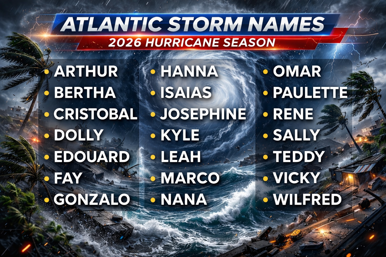
Track The Tropics is the #1 source to track the tropics 24/7! Since 2013 the main goal of the site is to bring all of the important links and graphics to ONE PLACE so you can keep up to date on any threats to land during the Atlantic Hurricane Season! Hurricane Season 2026 in the Atlantic starts on June 1st and ends on November 30th. Do you love Spaghetti Models? Well you've come to the right place!! Remember when you're preparing for a storm: Run from the water; hide from the wind!
Tropical Atlantic Weather Resources
- NOAA National Hurricane Center
- International Meteorology Database
- FSU Tropical Cyclone Track Probabilities
- Brian McNoldy Atlantic Headquarters
- Brian McNoldy Tropical Satellite Sectors
- Brian McNoldy Infrared Hovmoller
- Brian McNoldy Past TC Radar Loops
- Weather Nerds TC Guidance
- Twister Data Model Guidance
- NOAA Tropical Cyclone Tracks
- Albany GFS/ EURO Models/ Ensembles
- Albany Tropical Cyclone Guidance
- Albany Tropical Atlantic Model Maps
- Pivotal Weather Model Guidance
- Weather Online Model Guidance
- UKMet Model Guidance/ Analysis/ Sat
- ECMWF (EURO) Model Guidance
- FSU Tropical Model Outputs
- FSU Tropical Cyclone Genesis
- Penn State Tropical E-Wall
- NOAA HFIP Ruc Models
- Navy NRL TC Page
- College of DuPage Model Guidance
- WXCharts Model Guidance
- NOAA NHC Analysis Tools
- NOAA NHC ATCF Directory
- NOAA NCEP/EMC Cyclogenesis Tracking
- NOAA NCEP/EMC HWRF Model
- NOAA HFIP Model Products
- University of Miami Ocean Heat
- COLA Max Potential Hurricane Intensity
- Colorado State RAMMB TC Tracking
- Colorado State RAMMB Floaters
- Colorado State RAMMB GOES-16 Viewer
- NOAA NESDIS GOES Satellite
- ASCAT Ocean Surface Winds METOP-A
- ASCAT Ocean Surface Winds METOP-B
- Michael Ventrice Waves / MJO Maps
- TropicalAtlantic.com Analysis / Recon
- NCAR/RAL Tropical Cyclone Guidance
- CyclonicWX Tropical Resources
Historic Louisiana Storms By Month
January
June
July
August
September
October
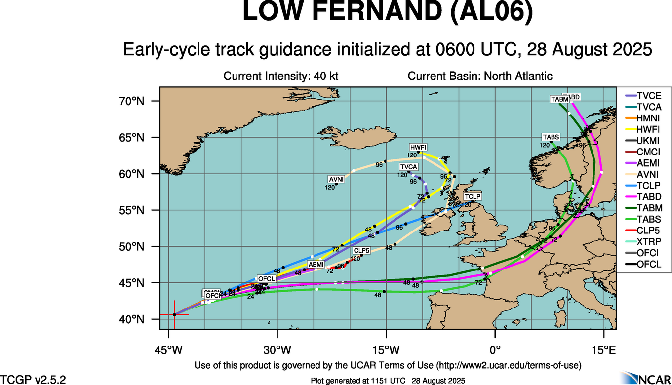
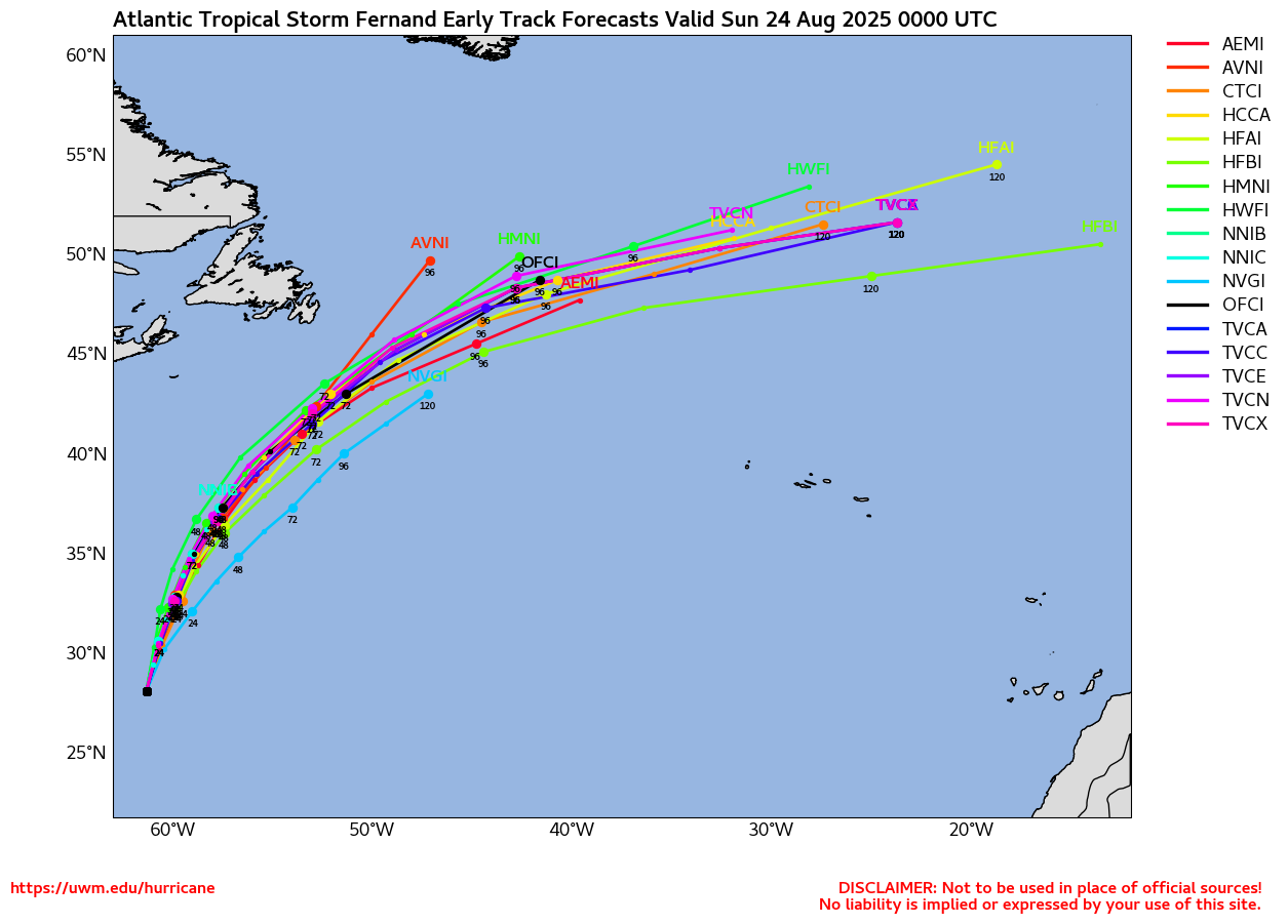
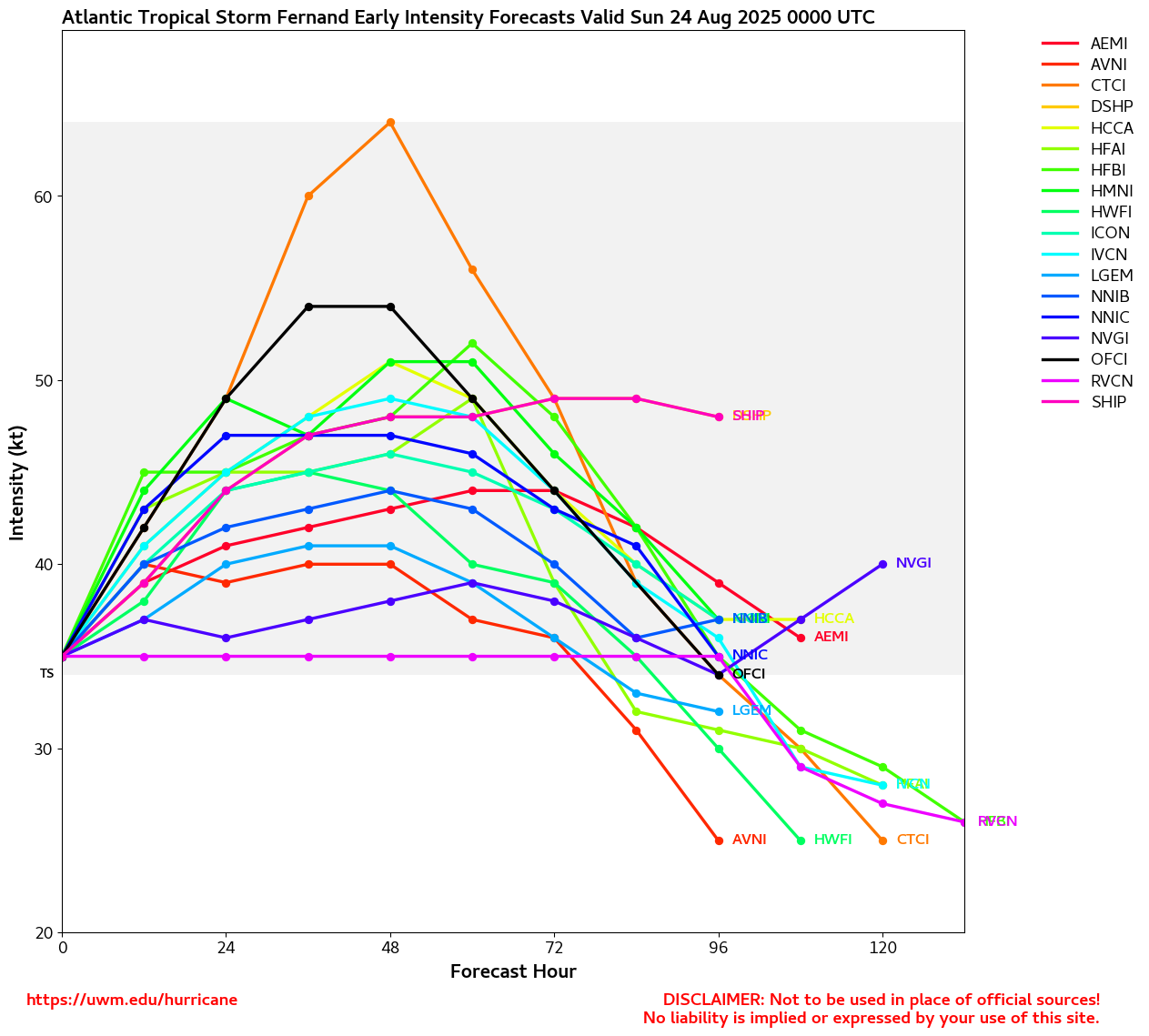
Tracking Fernand– 2025 Atlantic Hurricane Season
NHC Important Links: NHC Discussion / Public Advisory / Forecast Advisory / Wind Probs / NWS Local Products / US Watch/Warning / Graphics / Storm Archive
Storm Tracking Important Links:
Wind Analysis /
Coastal Inundation Info /
Tide Information /
Surge Map /
Surge Potential /
Coastal Risk Map /
Microwave Imagery /
Advanced Dvorak ADT /
GOES19 Satellite Storm Page /
FSU Track Probability /
Colorado State Tracker
/
Navy NRL Page
/
NHC Best Track
/
NOAA AOML Tracker
/
Tropical Atlantic
/
NCAR Guidance Page /
CyclonicWX
/
CIMSS Tracker
/ Tropical Tidbits
/ UWM Tracker
/ WeatherNerds
NOAA NESDIS Floaters
Other Floaters:WeatherNerds - NRL Floaters - CyclonicWx - RAMMB Sat -
RAMMB Model Data -
RAMMB Wind Products
Other Floaters:WeatherNerds - NRL Floaters - CyclonicWx - RAMMB Sat -
RAMMB Model Data -
RAMMB Wind Products
122 Visitors Tracking The Tropics in the past hour!
SUPPORT TRACK THE TROPICS
Over the last decade plus if you appreciate the information and tracking I provide during the season along with this website which donations help keep it running please consider a one time... recurring or yearly donation if you are able to help me out...
NHC Public Advisory
- Tue, 22 Sep 2026 02:33:14 +0000: Atlantic Tropical Storm Fay Advisory Number 11 - Atlantic Tropical Storm Fay Advisory Number 11
000
WTNT31 KNHC 220233
TCPAT1
BULLETIN
Tropical Storm Fay Advisory Number 11
NWS National Hurricane Center Miami FL AL062026
300 AM GMT Tue Sep 22 2026
...FAY CONTINUES TO WEAKEN...
SUMMARY OF 300 AM GMT...0300 UTC...INFORMATION
----------------------------------------------
LOCATION...32.3N 33.1W
ABOUT 525 MI...840 KM SW OF THE AZORES
MAXIMUM SUSTAINED WINDS...40 MPH...65 KM/H
PRESENT MOVEMENT...SW OR 215 DEGREES AT 8 MPH...13 KM/H
MINIMUM CENTRAL PRESSURE...1008 MB...29.77 INCHES
WATCHES AND WARNINGS
--------------------
There are no coastal watches or warnings in effect.
DISCUSSION AND OUTLOOK
----------------------
At 300 AM GMT (0300 UTC), the center of Tropical Storm Fay was
located near latitude 32.3 North, longitude 33.1 West. Fay is moving
toward the southwest near 8 mph (13 km/h). A gradual turn toward the
west-southwest then west is expected through midweek.
Maximum sustained winds have decreased to near 40 mph (65 km/h) with
higher gusts. Continued weakening is forecast, and Fay is likely to
degenerate into a post-tropical remnant low by late Tuesday.
Tropical-storm-force winds extend outward up to 70 miles (110 km)
from the center.
The estimated minimum central pressure is 1008 mb (29.77 inches).
HAZARDS AFFECTING LAND
----------------------
None.
NEXT ADVISORY
-------------
Next complete advisory at 900 AM GMT.
$$
Forecaster Adams
NHC Forecast Advisory
- Tue, 22 Sep 2026 02:33:14 +0000: Atlantic Tropical Storm Fay Forecast/Advisory Numb... - Atlantic Tropical Storm Fay Forecast/Advisory Number 11
000
WTNT21 KNHC 220233
TCMAT1
TROPICAL STORM FAY FORECAST/ADVISORY NUMBER 11
NWS NATIONAL HURRICANE CENTER MIAMI FL AL062026
0300 UTC TUE SEP 22 2026
TROPICAL STORM CENTER LOCATED NEAR 32.3N 33.1W AT 22/0300Z
POSITION ACCURATE WITHIN 20 NM
PRESENT MOVEMENT TOWARD THE SOUTHWEST OR 215 DEGREES AT 7 KT
ESTIMATED MINIMUM CENTRAL PRESSURE 1008 MB
MAX SUSTAINED WINDS 35 KT WITH GUSTS TO 45 KT.
34 KT....... 60NE 50SE 40SW 60NW.
4 M SEAS.... 60NE 0SE 30SW 90NW.
WINDS AND SEAS VARY GREATLY IN EACH QUADRANT. RADII IN NAUTICAL
MILES ARE THE LARGEST RADII EXPECTED ANYWHERE IN THAT QUADRANT.
REPEAT...CENTER LOCATED NEAR 32.3N 33.1W AT 22/0300Z
AT 22/0000Z CENTER WAS LOCATED NEAR 32.6N 32.7W
FORECAST VALID 22/1200Z 31.6N 34.1W
MAX WIND 30 KT...GUSTS 40 KT.
FORECAST VALID 23/0000Z 30.7N 36.0W...POST-TROP/REMNT LOW
MAX WIND 30 KT...GUSTS 40 KT.
FORECAST VALID 23/1200Z 30.1N 37.8W...POST-TROP/REMNT LOW
MAX WIND 25 KT...GUSTS 35 KT.
FORECAST VALID 24/0000Z 29.7N 39.6W...POST-TROP/REMNT LOW
MAX WIND 25 KT...GUSTS 35 KT.
FORECAST VALID 24/1200Z 29.5N 41.2W...POST-TROP/REMNT LOW
MAX WIND 25 KT...GUSTS 35 KT.
FORECAST VALID 25/0000Z 29.5N 42.5W...POST-TROP/REMNT LOW
MAX WIND 25 KT...GUSTS 35 KT.
EXTENDED OUTLOOK. NOTE...ERRORS FOR TRACK HAVE AVERAGED NEAR 125 NM
ON DAY 4 AND 175 NM ON DAY 5...AND FOR INTENSITY NEAR 15 KT EACH DAY
OUTLOOK VALID 26/0000Z 29.5N 44.3W...POST-TROP/REMNT LOW
MAX WIND 25 KT...GUSTS 35 KT.
OUTLOOK VALID 27/0000Z...DISSIPATED
REQUEST FOR 3 HOURLY SHIP REPORTS WITHIN 300 MILES OF 32.3N 33.1W
NEXT ADVISORY AT 22/0900Z
$$
FORECASTER ADAMS
NHC Discussion
- Tue, 22 Sep 2026 02:33:44 +0000: Atlantic Tropical Storm Fay Discussion Number 11 - Atlantic Tropical Storm Fay Discussion Number 11
000
WTNT41 KNHC 220233
TCDAT1
Tropical Storm Fay Discussion Number 11
NWS National Hurricane Center Miami FL AL062026
300 AM GMT Tue Sep 22 2026
Fay is feeling the effects of strong west-northwesterly wind shear
tonight. Nearly all of the convection is displaced well to the east
of the fully exposed low-level center, and low-level water vapor
imagery shows dry air enveloping much of the system. Recent
objective and subjective Dvorak intensity estimates have decreased
over the past several hours and range from 25-38 kt. Based on the
degraded satellite presentation and the downward trend in intensity
estimates, the initial intensity is set at 35 kt for this advisory.
The tropical storm is moving southwestward, or 215/07 kt, along the
southeastern periphery of a weak mid-level ridge centered west of
the system. A gradual turn toward the west-southwest and then west
is expected over the next few days as the ridge strengthens and
expands eastward across the central Atlantic. The official NHC track
forecast is very similar to the previous advisory and remains close
to the HCCA solution.
Continued weakening is expected on Tuesday as dry mid-level air
wraps around the periphery of Fay. In fact, simulated satellite
imagery from the ECMWF and GFS suggests that Fay may struggle to
maintain organized convection as early as Tuesday, and the system
could become post-tropical by that time. However, the strong
upper-level trough currently producing significant wind shear over
the region is forecast to lift away from Fay over the next day or
so, while the cyclone may move over slightly warmer waters in the
coming days. These changes could briefly allow for some shallow
convection to redevelop around midweek, although any such resurgence
is expected to be short-lived. Given the overall unfavorable
environment and anticipated weakening, the latest NHC forecast shows
Fay becoming a post-tropical remnant low by Tuesday night.
FORECAST POSITIONS AND MAX WINDS
INIT 22/0300Z 32.3N 33.1W 35 KT 40 MPH
12H 22/1200Z 31.6N 34.1W 30 KT 35 MPH
24H 23/0000Z 30.7N 36.0W 30 KT 35 MPH...POST-TROP/REMNT LOW
36H 23/1200Z 30.1N 37.8W 25 KT 30 MPH...POST-TROP/REMNT LOW
48H 24/0000Z 29.7N 39.6W 25 KT 30 MPH...POST-TROP/REMNT LOW
60H 24/1200Z 29.5N 41.2W 25 KT 30 MPH...POST-TROP/REMNT LOW
72H 25/0000Z 29.5N 42.5W 25 KT 30 MPH...POST-TROP/REMNT LOW
96H 26/0000Z 29.5N 44.3W 25 KT 30 MPH...POST-TROP/REMNT LOW
120H 27/0000Z...DISSIPATED
$$
Forecaster Adams