374 Visitors Tracking The Tropics!
PLEASE SUPPORT TRACK THE TROPICS
Track The Tropics is the #1 source to track the tropics 24/7! Since 2013 the main goal of the site is to bring all of the important links and graphics to ONE PLACE so you can keep up to date on any threats to land during the Atlantic Hurricane Season! Hurricane Season 2026 in the Atlantic starts on June 1st and ends on November 30th. Do you love Spaghetti Models? Well you've come to the right place!! Remember when you're preparing for a storm: Run from the water; hide from the wind!
Tropical Atlantic Weather Resources
- NOAA National Hurricane Center
- International Meteorology Database
- FSU Tropical Cyclone Track Probabilities
- Brian McNoldy Atlantic Headquarters
- Brian McNoldy Tropical Satellite Sectors
- Brian McNoldy Infrared Hovmoller
- Brian McNoldy Past TC Radar Loops
- Weather Nerds TC Guidance
- Twister Data Model Guidance
- NOAA Tropical Cyclone Tracks
- Albany GFS/ EURO Models/ Ensembles
- Albany Tropical Cyclone Guidance
- Albany Tropical Atlantic Model Maps
- Pivotal Weather Model Guidance
- Weather Online Model Guidance
- UKMet Model Guidance/ Analysis/ Sat
- ECMWF (EURO) Model Guidance
- FSU Tropical Model Outputs
- FSU Tropical Cyclone Genesis
- Penn State Tropical E-Wall
- NOAA HFIP Ruc Models
- Navy NRL TC Page
- College of DuPage Model Guidance
- WXCharts Model Guidance
- NOAA NHC Analysis Tools
- NOAA NHC ATCF Directory
- NOAA NCEP/EMC Cyclogenesis Tracking
- NOAA NCEP/EMC HWRF Model
- NOAA HFIP Model Products
- University of Miami Ocean Heat
- COLA Max Potential Hurricane Intensity
- Colorado State RAMMB TC Tracking
- Colorado State RAMMB Floaters
- Colorado State RAMMB GOES-16 Viewer
- NOAA NESDIS GOES Satellite
- ASCAT Ocean Surface Winds METOP-A
- ASCAT Ocean Surface Winds METOP-B
- Michael Ventrice Waves / MJO Maps
- TropicalAtlantic.com Analysis / Recon
- NCAR/RAL Tropical Cyclone Guidance
- CyclonicWX Tropical Resources
Historic Louisiana Storms By Month
January
June
July
August
September
October
Tropical Cyclone Safety – Windows and Doors
Tropical Cyclone Safety Improvements: Windows and Doors
Windows
 One of the best ways to protect a home from damage in wind storms is to install impact-resistant shuttersover all large windows and glass doors. Not only do they protect doors and windows from wind-borne objects, but they can reduce damage caused by sudden pressure changes when a window or door is broken. Laminated window systems (plastic bonded to glass) are another option, and are a particularly good choice for either building a new home or adding to an old one.
Manufactured Shutters
If your residence has permanent shutters, evaluate their effectiveness. Manufacturers are responsible for testing their shutters up to the standards necessary to resist wind forces and wind-borne debris. Some shutters are very flexible, especially those that roll up. If struck by a rigid piece of debris, shutters may break the window. To determine whether your shutter can resist this impact, gently lean against it and see if it yields. You can also inspect your shutters to see if they are properly attached to the house and will not fly off during a storm by inspecting the shutter connectors for obvious excessive wear or missing connectors. Ask your shutter manufacturer for proper installation criteria.Doors
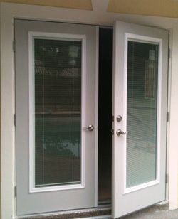 Your home has either double or single entry doors. If they are solid wood or hollow metal they probably can resist wind pressures and hurricane debris. However, if you are not sure whether they are strong enough, take these precautions:
- Install head and foot bolts on the inactive door of double-entry doors. (Shown here) Make sure your doors have at least three hinges and a dead bolt security lock which has a minimum one inch bolt throw length.
- Since double entry doors fail when their surface bolts break at the header trim or threshold, check the connections at both places. Be sure the surface bolt extends into the door header and through the threshold into the subfloor.
Tropical Cyclone Safety Improvements: Roofs and Walls
Gabled Roofs
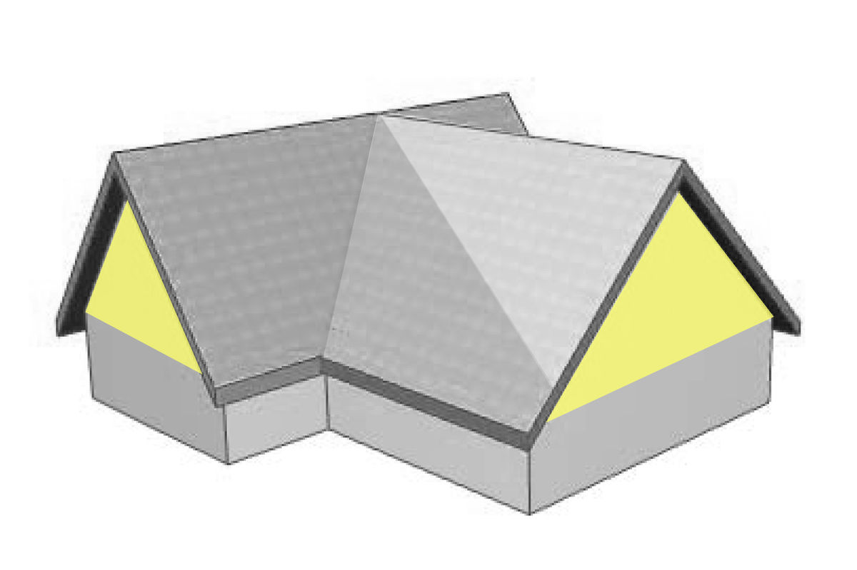 Does your home have a gabled roof? If so, the end wall of your home takes a tremendous beating during a hurricane. If not properly braced, it can collapse, causing significant damage. However, gable end walls are easy to strengthen and deserve to be a high priority on your retrofit list. Although truss bracing is not endorsed by IBHS, the Red Cross and others recommend it as a retrofit for gabled roofs. To do this yourself, install 2x4s the length of your roof, overlapping the ends of the 2x4s across two trusses.
Typically, gable end trusses are directly attached to the top of gable end walls. The bottom of the truss must be securely nailed to the top of the wall and braced to adjacent trusses. This prevents wind from pushing or pulling the gable end at its critical point, where the gable truss is connected along the gable wall. Without adequate bracing, the end wall may be destroyed during hurricane winds.
To secure your gable end wall, fasten eight-foot long braces to the bottom chord of the gable truss and the adjacent trusses with sixteen-penny (16d) nails. The braces should be perpendicular to the truss, spaced at a maximum of four feet on center. In addition, be sure to tie back the gable truss with at least one eight-foot long brace, along the ridge of the roof, to several of the interior trusses.
Shingles
Shingles are usually not designed to resist hurricane force winds. They come with integral locking tabs or factory-applied adhesives that on occasion do not adhere properly to the underlying shingle because of cold weather installation, uneven surfaces or any number of other reasons. For increased wind resistance, have a qualified person inspect several shingle tabs to see if the adhesive has engaged. If not, use a quick-setting asphalt cement to bond them together. To cement the shingle tabs to the underlying shingles, place two spots of quick-setting asphalt cement about the size of a quarter under each tab with a putty knife or caulking gun. Press the tab into the adhesive. Be sure to cement all the tabs throughout the roof, being careful not to bend them farther than necessary when applying the adhesive. Replace any damaged shingles immediately.Attach Roof Sheathing with Adhesive
You can also improve the uplift resistance of the roof deck from the attic without removing the roof covering. This is how...- Using a caulking gun, apply a ¼" bead of wood adhesive along the intersection of the roof deck and the roof support element (rafter or truss chord) on both sides.
- At places where you have limited access, such as where the roof meets exterior walls, use quarter round pieces of wood approximately two to three feet long and apply the adhesive along the two adjacent sides of the block. The length of the quarter round pieces can be longer or shorter to suit your installation needs.
- Press the wood pieces in the intersection making sure the adhesive has made solid contact with the sheathing and roof support elements.
Roof to Top of Wall Connection
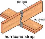 Metal hurricane straps or clips provide the proper measure of strength and safety for the roof-to-wall connection. The common practice of toenailing the trusses or rafters often is not sufficient to hold a roof in place in high winds. These clips or straps are usually very difficult to see from the attic because of insulation.
Areas where the roof framing meets the top of stud walls are normally covered by dry wall on the inside and by wall cladding and soffit board on the outside. To install hurricane straps and clips, remove the roof sheathing around the perimeter of the roof to reveal the top of the wall. You may also need to remove the soffit and exterior cladding to reveal the top 12" to 18" of the wall. In addition, if the exterior cladding is brick veneer, you may need to remove small sections of brick as needed.
If your roof has trusses, make sure you tie them to the wall by either anchoring to the top plate and then the top plate to the wall stud, or strapping the truss directly to the wall stud.
Tropical Cyclone Safety: Protecting Garage Doors
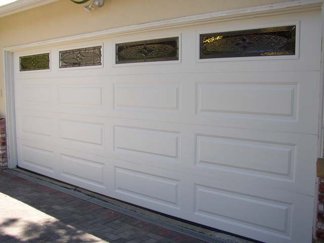 Because of their width, double-wide garage doors are more susceptible to wind damage than single doors. Unless you have a tested hurricane-resistant door, the wind may force it out of the roller track -- especially if the track is light weight or some of the anchor bolts are not in place. This occurs because the door deflects too much under excessive wind pressure and fails.
To secure your garage door:
- Check with your local government building official to see if there are code requirements for garage doors in your area.
- Check with your local building supplier or garage door retailer to see if a retrofit kit is available for your garage door.
- You should probably reinforce your double-wide garage door at its weakest points. This involves installing horizontal and/or vertical bracing onto each panel, using wood or light gauge metal girds bolted to the door mullions. You may also need heavier hinges and stronger end and vertical supports for your door.

 DONATE