356 Visitors Tracking The Tropics!

SHOW ME SOME LOVE AND SUPPORT
Website: TrackTheTropics.com/DONATE
Venmo: @TrackTheTropicsLouisiana
Cash App: Cash.App/$TrackTheTropics
Subscribe: FB.com/TrackTheTropics
Website: TrackTheTropics.com/DONATE
Venmo: @TrackTheTropicsLouisiana
Cash App: Cash.App/$TrackTheTropics
Subscribe: FB.com/TrackTheTropics

Track The Tropics is the #1 source to track the tropics 24/7! Since 2013 the main goal of the site is to bring all of the important links and graphics to ONE PLACE so you can keep up to date on any threats to land during the Atlantic Hurricane Season! Hurricane Season 2026 in the Atlantic starts on June 1st and ends on November 30th. Do you love Spaghetti Models? Well you've come to the right place!! Remember when you're preparing for a storm: Run from the water; hide from the wind!
Tropical Atlantic Weather Resources
- NOAA National Hurricane Center
- International Meteorology Database
- FSU Tropical Cyclone Track Probabilities
- Brian McNoldy Atlantic Headquarters
- Brian McNoldy Tropical Satellite Sectors
- Brian McNoldy Infrared Hovmoller
- Brian McNoldy Past TC Radar Loops
- Weather Nerds TC Guidance
- Twister Data Model Guidance
- NOAA Tropical Cyclone Tracks
- Albany GFS/ EURO Models/ Ensembles
- Albany Tropical Cyclone Guidance
- Albany Tropical Atlantic Model Maps
- Pivotal Weather Model Guidance
- Weather Online Model Guidance
- UKMet Model Guidance/ Analysis/ Sat
- ECMWF (EURO) Model Guidance
- FSU Tropical Model Outputs
- FSU Tropical Cyclone Genesis
- Penn State Tropical E-Wall
- NOAA HFIP Ruc Models
- Navy NRL TC Page
- College of DuPage Model Guidance
- WXCharts Model Guidance
- NOAA NHC Analysis Tools
- NOAA NHC ATCF Directory
- NOAA NCEP/EMC Cyclogenesis Tracking
- NOAA NCEP/EMC HWRF Model
- NOAA HFIP Model Products
- University of Miami Ocean Heat
- COLA Max Potential Hurricane Intensity
- Colorado State RAMMB TC Tracking
- Colorado State RAMMB Floaters
- Colorado State RAMMB GOES-16 Viewer
- NOAA NESDIS GOES Satellite
- ASCAT Ocean Surface Winds METOP-A
- ASCAT Ocean Surface Winds METOP-B
- Michael Ventrice Waves / MJO Maps
- TropicalAtlantic.com Analysis / Recon
- NCAR/RAL Tropical Cyclone Guidance
- CyclonicWX Tropical Resources
Earn CASH Back On Gas $$$$ 
Shop Store For Essentials
Historic Louisiana Storms By Month
January
June
July
August
September
October
2018 Atlantic Hurricane Season Officially Ends
The 2018 Atlantic hurricane season is OVER! Despite almost all major forecasting groups calling for a BELOW average season this year was actually an ABOVE average season and was the third consecutive above-average damaging season. These groups were banking on cooler than normal sea surface temperatures in the tropical Atlantic and the anticipated development of an El Niño… well the El Niño failed to develop in time to suppress activity. That is one reason I always say you can’t really predict these variables and seasons very far out. The 2018 season featured 15 named storms, 8 hurricanes and 2 major hurricanes and a totaled $33.3 billion (2018 USD) in damages. Check out the 2018 Tracking Map Of All Storms below...
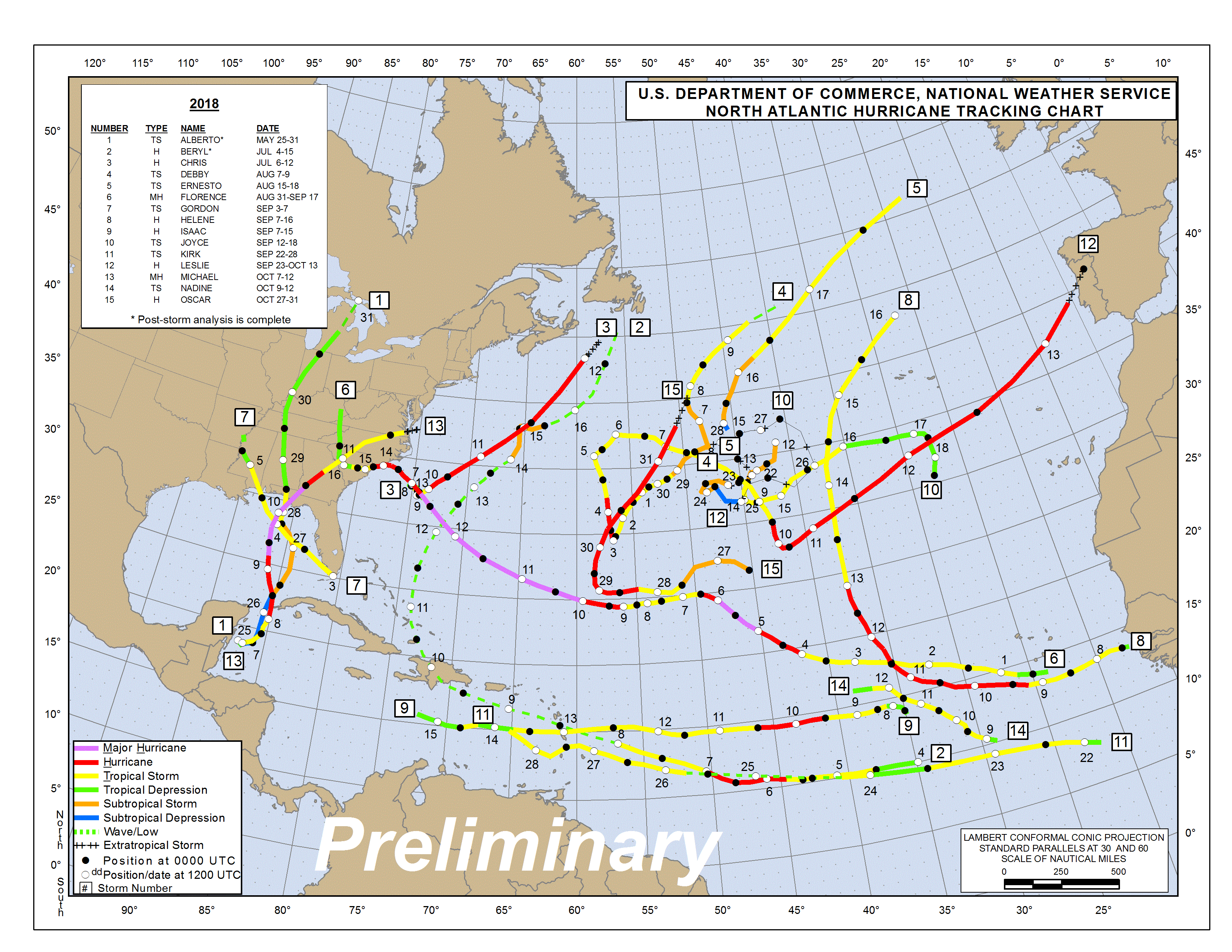
While most of the storms stayed out to sea in the deep Atlantic 4 of them made landfall in the U.S. (Alberto, Gordon, Florence and Michael). The season will be mostly be remembered for 2 major Hurricanes making landfall in the United States and other countries causing extensive damage and loss of life… Florence and Michael.
Hurricane Florence formed on August 31, 2018 and dissipated on September 19th, 2018. Florence reached its peak intensity on September 10th with 140 mph sustained winds and a central pressure of 939 mbar. Early on September 14, Florence made landfall in the United States just south of Wrightsville Beach, North Carolina. The storm caused 30 direct and 23 indirect fatalities and totaled $17.9 billion (2018 USD) in damages in the U.S. and other countries.
Hurricane Michael formed on October 7, 2018 and dissipated on October 16, 2018. Michael reached its peak intensity of 155 mph sustained winds and a central pressure of 919 mbar on October 10th as a high-end Category 4 hurricane and made landfall that same day near Mexico Beach, Florida. The storm caused 60 fatalities and totaled $15 billion (2018 USD) in damages in the U.S. and other countries.
Other tidbits from the season:
On September 12, Joyce formed, making 2018 the first season since 2008 to feature four named storms active simultaneously (Florence, Helene, Isaac, and Joyce).
The formation of Tropical Storm Alberto on May 25, marked the fourth consecutive year in which a storm developed before the official start of the season.
The next storm, Beryl, became the first hurricane to form in the eastern Atlantic during the month of July since Bertha in 2008.
Chris, upgraded to a hurricane on July 10, became the earliest second hurricane in a season since 2005.
No hurricanes formed in the Atlantic during the month of August, marking the first season since 2013, and the eighth season on record, to do so.
On September 5, Florence became the first major hurricane of the season.
On October 9, Michael became the second major hurricane of the season, and a day later, it became the third-most intense hurricane to make landfall on the United States in terms of pressure, behind the 1935 Labor Day hurricane and Hurricane Camille of 1969.
With the formation of Oscar on October 27, the season is the first on record to see seven storms that were subtropical at some point in their lifetimes (Alberto, Beryl, Debby, Ernesto, Joyce, Leslie, and Oscar).
***Always stay alert, prepared and informed every season… the 2019 Hurricane Season is up next and is only 182 DAYS AWAY!!! be sure to bookmark my website and visiting it daily during every season!!!***
Tagged 2018, Damage, Florence, forecast, History, Hurricane, Hurricanes, Impact, Michael, Season, Statistics, storms, Tropical, United States