
![[Map of 1950-2017 CONUS Hurricane Strikes]](http://www.nhc.noaa.gov/climo/images/conus_strikes.jpg)


ATTENTION: The NHC has issued it's last advisory on Gamma as of 10-6-2020. All Graphics and Information on this page will eventually cease to update.
NHC Important Links:
NHC Discussion / NHC Public Advisory / NHC Forecast / Wind Probs / Storm Archive
Storm Tracking Important Links:
FSU Track Probability - NOAA Tracker - Albany Tracker - Navy NRL Page - HFIP Products - TropicalAtlantic Tracker - NCAR Guidance Page - CyclonicWX Tracker Products - CIMSS Tracker - TropicalTidbits Tracker - UWM Tracker - SFWMD Models
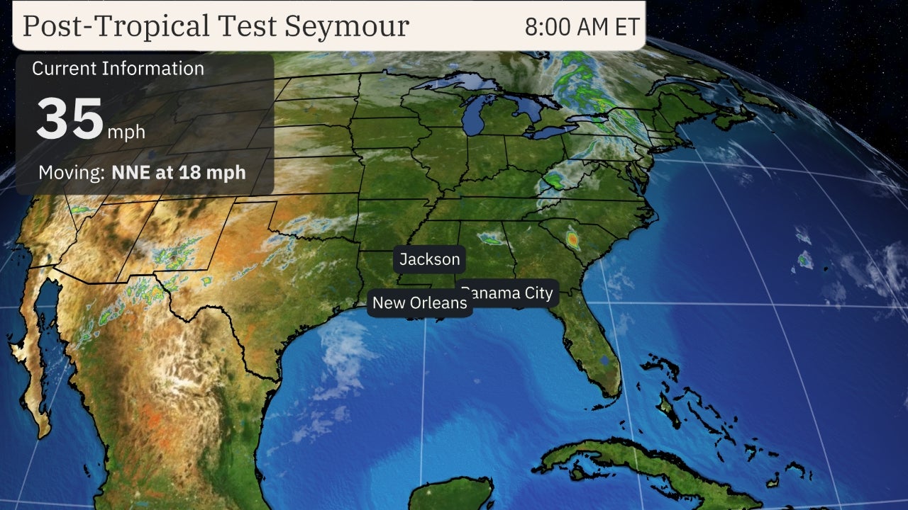
Projected Path with Watches and Warnings

Zoomed In Watches and Warnings
 Additional Projected Path Swath

Zoomed In Watches and Warnings
Additional Projected Path Swath
Most Likely Arrival Time of Tropical Storm Force Winds
 Most Reasonable Arrival Time of Tropical Storm Force Winds
 Hurricane Force Wind Probabilities
 Tropical Storm Force Wind Probabilities

Most Reasonable Arrival Time of Tropical Storm Force Winds
Hurricane Force Wind Probabilities
Tropical Storm Force Wind Probabilities
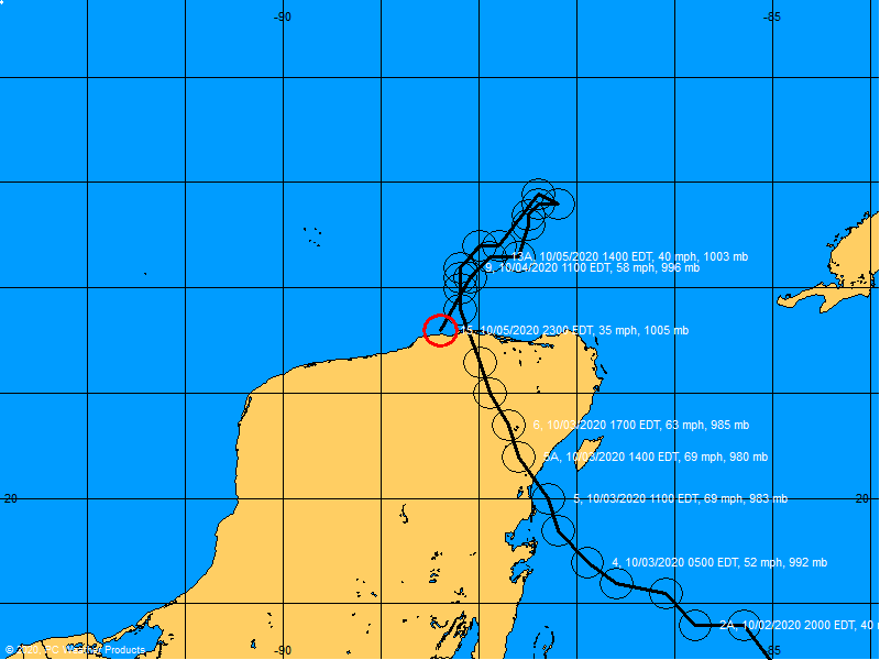
Past Track History

NRL Floater

Additional RAMMB Sat - Model Data - Wind Products
NOAA NESDIS Floaters


Other Floaters:
TropicalTidbits - WeatherNerds - GOES16
Additional RAMMB Sat - Model Data - Wind Products
NOAA NESDIS Floaters
Other Floaters:
TropicalTidbits - WeatherNerds - GOES16


Surface Wind Field
 Cumulative Wind History
 Top Analog Tracks

Cumulative Wind History
Top Analog Tracks
Windfield
Microwave Imagery
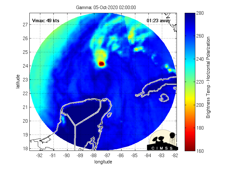
Microwave Imagery
Gamma Key Messages

5Radar Loops Near TD25


Intensity Forecasts
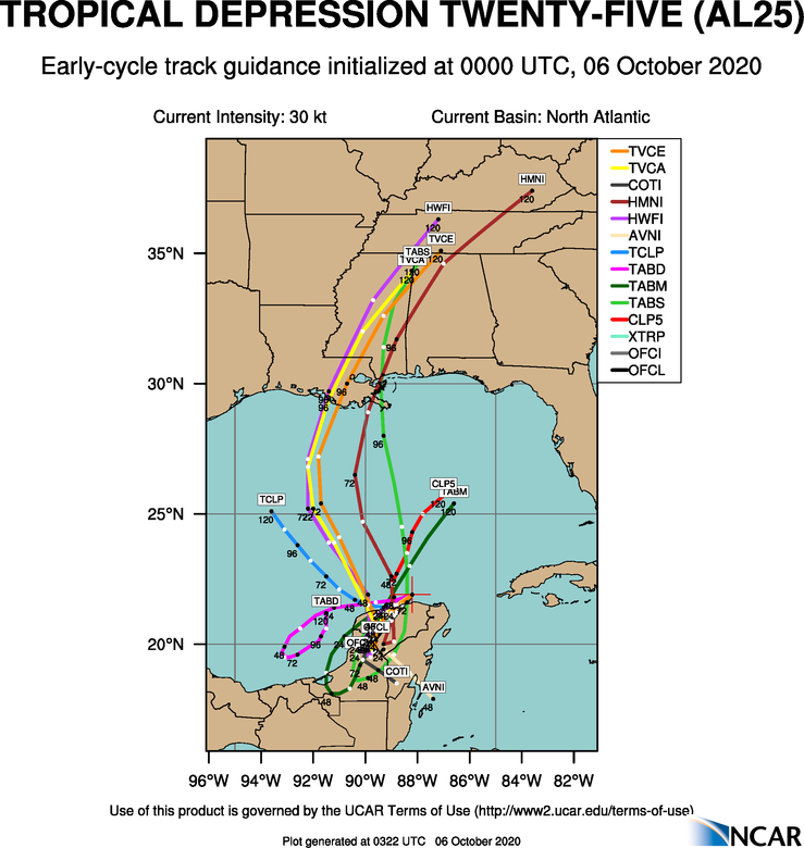
 Model Tracks


 GFS / Canadian Ensemble Tracks

EURO Ensemble Tracks
EPS Ensemble Tracks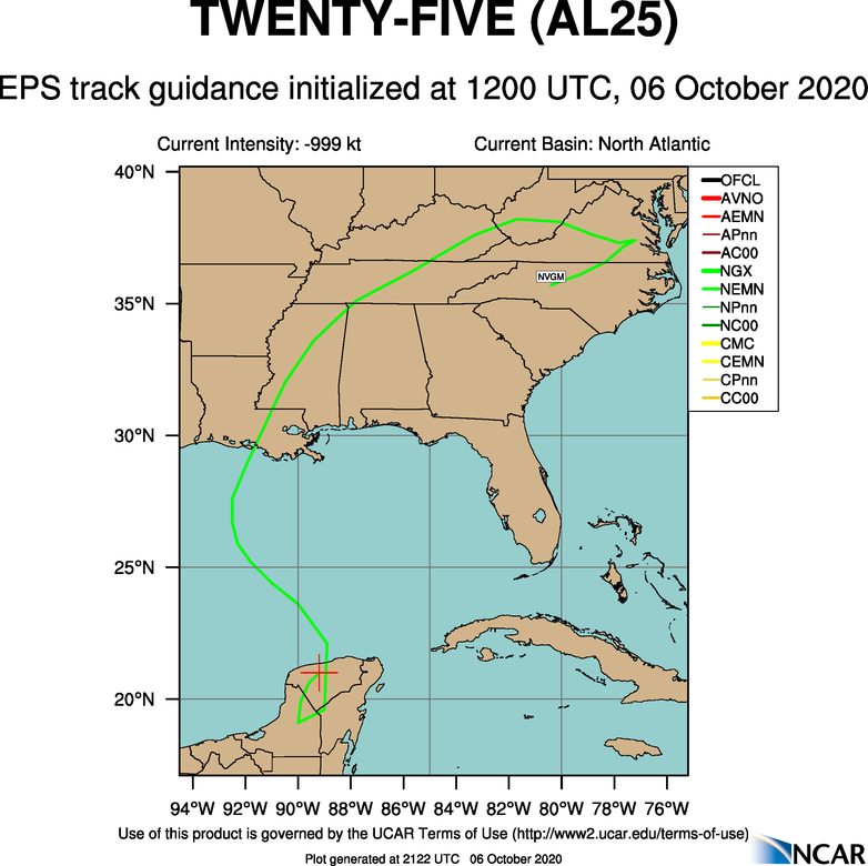
Model Tracks
GFS / Canadian Ensemble Tracks
EURO Ensemble Tracks
EPS Ensemble Tracks
- Sun, 29 Oct 2023 08:35:50 +0000: Atlantic Post-Tropical Cyclone Tammy Advisory Number 40 - Atlantic Post-Tropical Cyclone Tammy Advisory Number 40
000
WTNT35 KNHC 290835
TCPAT5
BULLETIN
Post-Tropical Cyclone Tammy Advisory Number 40
NWS National Hurricane Center Miami FL AL202023
500 AM AST Sun Oct 29 2023
...TAMMY NOW A POST-TROPICAL CYCLONE...
...THIS IS THE LAST NHC ADVISORY...
SUMMARY OF 500 AM AST...0900 UTC...INFORMATION
----------------------------------------------
LOCATION...32.4N 53.3W
ABOUT 670 MI...1080 KM E OF BERMUDA
MAXIMUM SUSTAINED WINDS...40 MPH...65 KM/H
PRESENT MOVEMENT...E OR 100 DEGREES AT 18 MPH...30 KM/H
MINIMUM CENTRAL PRESSURE...1002 MB...29.59 INCHES
WATCHES AND WARNINGS
--------------------
There are no coastal watches or warnings in effect.
DISCUSSION AND OUTLOOK
----------------------
At 500 AM AST (0900 UTC), the center of Post-Tropical Cyclone Tammy
was located near latitude 32.4 North, longitude 53.3 West. The
post-tropical cyclone is moving toward the east near 18 mph (30
km/h). A turn to the south is expected tonight, followed by a
motion to the southwest on Monday and Tuesday.
Maximum sustained winds are near 40 mph (65 km/h) with higher gusts.
Gradual weakening is expected during the next couple of days.
Tropical-storm-force winds extend outward up to 90 miles (150 km)
south of the center.
The estimated minimum central pressure is 1002 mb (29.59 inches).
HAZARDS AFFECTING LAND
----------------------
None.
NEXT ADVISORY
-------------
This is the last public advisory issued by the National Hurricane
Center on Tammy. Additional information on this system can be found
in High Seas Forecasts issued by the National Weather Service,
under AWIPS header NFDHSFAT1, WMO header FZNT01 KWBC, and online at
ocean.weather.gov/shtml/NFDHSFAT1.php
$$
Forecaster Cangialosi
- Sun, 29 Oct 2023 08:35:22 +0000: Atlantic Post-Tropical Cyclone TAMMY Forecast/Advi... - Atlantic Post-Tropical Cyclone TAMMY Forecast/Advisory Number 40 NWS NATIONAL Hurricane CENTER MIAMI FL AL202023 0900 UTC SUN OCT 29 2023 NOTICE... LAND-BASED TROPICAL Cyclone WATCHES AND WARNINGS ARE NO LONGER INCLUDED IN THE TROPICAL CYCLONE FORECAST/Advisory...(TCM). CURRENT LAND-BASED COASTAL WATCHES AND WARNINGS CAN BE FOUND IN THE MOST RECENTLY ISSUED TROPICAL CYCLONE PUBLIC ADVISORY...(TCP). POST-TROPICAL CYCLONE CENTER LOCATED NEAR 32.4N 53.3W AT 29/0900Z POSITION ACCURATE WITHIN 30 NM PRESENT MOVEMENT TOWARD THE EAST OR 100 DEGREES AT 16 KT ESTIMATED MINIMUM CENTRAL PRESSURE 1002 MB MAX SUSTAINED WINDS 35 KT WITH GUSTS TO 45 KT. 34 KT....... 0NE 60SE 80SW 0NW. 12 FT SEAS.. 90NE 90SE 150SW 60NW. WINDS AND SEAS VARY GREATLY IN EACH QUADRANT. RADII IN NAUTICAL MILES ARE THE LARGEST RADII EXPECTED ANYWHERE IN THAT QUADRANT. REPEAT...CENTER LOCATED NEAR 32.4N 53.3W AT 29/0900Z AT 29/0600Z CENTER WAS LOCATED NEAR 32.6N 54.3W FORECAST VALID 29/1800Z 31.6N 50.4W...POST-TROP/REMNT LOW MAX WIND 30 KT...GUSTS 40 KT. FORECAST VALID 30/0600Z 30.1N 47.6W...POST-TROP/REMNT LOW MAX WIND 30 KT...GUSTS 40 KT. FORECAST VALID 30/1800Z 28.5N 46.7W...POST-TROP/REMNT LOW MAX WIND 25 KT...GUSTS 35 KT. FORECAST VALID 31/0600Z 27.2N 46.6W...POST-TROP/REMNT LOW MAX WIND 20 KT...GUSTS 30 KT. FORECAST VALID 31/1800Z 26.1N 48.0W...POST-TROP/REMNT LOW MAX WIND 20 KT...GUSTS 30 KT. FORECAST VALID 01/0600Z...DISSIPATED REQUEST FOR 3 HOURLY SHIP REPORTS WITHIN 300 MILES OF 32.4N 53.3W THIS IS THE LAST FORECAST/ADVISORY ISSUED BY THE NATIONAL HURRICANE CENTER ON THIS SYSTEM. ADDITIONAL INFORMATION ON THIS SYSTEM CAN BE FOUND IN HIGH SEAS FORECASTS ISSUED BY THE NATIONAL WEATHER SERVICE...UNDER AWIPS HEADER NFDHSFAT1 AND WMO HEADER FZNT01 KWBC. $$ FORECASTER CANGIALOSI
000
WTNT25 KNHC 290835
TCMAT5
POST-TROPICAL CYCLONE TAMMY FORECAST/ADVISORY NUMBER 40
NWS NATIONAL HURRICANE CENTER MIAMI FL AL202023
0900 UTC SUN OCT 29 2023
NOTICE... LAND-BASED TROPICAL CYCLONE WATCHES AND WARNINGS ARE NO
LONGER INCLUDED IN THE TROPICAL CYCLONE FORECAST/ADVISORY...(TCM).
CURRENT LAND-BASED COASTAL WATCHES AND WARNINGS CAN BE FOUND IN THE
MOST RECENTLY ISSUED TROPICAL CYCLONE PUBLIC ADVISORY...(TCP).
POST-TROPICAL CYCLONE CENTER LOCATED NEAR 32.4N 53.3W AT 29/0900Z
POSITION ACCURATE WITHIN 30 NM
PRESENT MOVEMENT TOWARD THE EAST OR 100 DEGREES AT 16 KT
ESTIMATED MINIMUM CENTRAL PRESSURE 1002 MB
MAX SUSTAINED WINDS 35 KT WITH GUSTS TO 45 KT.
34 KT....... 0NE 60SE 80SW 0NW.
12 FT SEAS.. 90NE 90SE 150SW 60NW.
WINDS AND SEAS VARY GREATLY IN EACH QUADRANT. RADII IN NAUTICAL
MILES ARE THE LARGEST RADII EXPECTED ANYWHERE IN THAT QUADRANT.
REPEAT...CENTER LOCATED NEAR 32.4N 53.3W AT 29/0900Z
AT 29/0600Z CENTER WAS LOCATED NEAR 32.6N 54.3W
FORECAST VALID 29/1800Z 31.6N 50.4W...POST-TROP/REMNT LOW
MAX WIND 30 KT...GUSTS 40 KT.
FORECAST VALID 30/0600Z 30.1N 47.6W...POST-TROP/REMNT LOW
MAX WIND 30 KT...GUSTS 40 KT.
FORECAST VALID 30/1800Z 28.5N 46.7W...POST-TROP/REMNT LOW
MAX WIND 25 KT...GUSTS 35 KT.
FORECAST VALID 31/0600Z 27.2N 46.6W...POST-TROP/REMNT LOW
MAX WIND 20 KT...GUSTS 30 KT.
FORECAST VALID 31/1800Z 26.1N 48.0W...POST-TROP/REMNT LOW
MAX WIND 20 KT...GUSTS 30 KT.
FORECAST VALID 01/0600Z...DISSIPATED
REQUEST FOR 3 HOURLY SHIP REPORTS WITHIN 300 MILES OF 32.4N 53.3W
THIS IS THE LAST FORECAST/ADVISORY ISSUED BY THE NATIONAL HURRICANE
CENTER ON THIS SYSTEM. ADDITIONAL INFORMATION ON THIS SYSTEM CAN BE
FOUND IN HIGH SEAS FORECASTS ISSUED BY THE NATIONAL WEATHER
SERVICE...UNDER AWIPS HEADER NFDHSFAT1 AND WMO HEADER FZNT01 KWBC.
$$
FORECASTER CANGIALOSI
- Sun, 29 Oct 2023 08:36:20 +0000: Atlantic Post-Tropical Cyclone Tammy Discussion Number 40 - Atlantic Post-Tropical Cyclone Tammy Discussion Number 40
000
WTNT45 KNHC 290836
TCDAT5
Post-Tropical Cyclone Tammy Discussion Number 40
NWS National Hurricane Center Miami FL AL202023
500 AM AST Sun Oct 29 2023
During the past 18 to 24 hours, Tammy has only been maintaining a
small and disorganized patch of deep convection well to the
northeast of the fully exposed center. Accordingly, the Dvorak
classifications have been decreasing, and the latest estimate from
TAFB is a T1.0/2.0. Satellite images also show that the low-level
center has become elongated and is losing definition. Based on
these characteristics, Tammy no longer qualifies as a tropical
cyclone, and this is the last advisory on this system. The
initial intensity is held at 35 kt.
Tammy is moving eastward at 16 kt in the mid-latitude westerlies. A
fairly sharp turn to the south is expected to occur tonight followed
by a motion to the southwest on Monday and Tuesday as the
post-tropical cyclone moves around the east side of a building
subtropical ridge. Tammy is expected to slowly weaken due to
continued strong vertical wind shear and dry air entrainment, and it
will likely dissipate in a few days.
Additional and future information on this system can be found in
High Seas Forecasts issued by the National Weather Service, under
AWIPS header NFDHSFAT1, WMO header FZNT01 KWBC, and online at
ocean.weather.gov/shtml/NFDHSFAT1.php
FORECAST POSITIONS AND MAX WINDS
INIT 29/0900Z 32.4N 53.3W 35 KT 40 MPH...POST-TROPICAL
12H 29/1800Z 31.6N 50.4W 30 KT 35 MPH...POST-TROP/REMNT LOW
24H 30/0600Z 30.1N 47.6W 30 KT 35 MPH...POST-TROP/REMNT LOW
36H 30/1800Z 28.5N 46.7W 25 KT 30 MPH...POST-TROP/REMNT LOW
48H 31/0600Z 27.2N 46.6W 20 KT 25 MPH...POST-TROP/REMNT LOW
60H 31/1800Z 26.1N 48.0W 20 KT 25 MPH...POST-TROP/REMNT LOW
72H 01/0600Z...DISSIPATED
$$
Forecaster Cangialosi
2 Day Tropical Weather Outlook
5 Day Tropical Weather Outlook
Facebook Comments